The most beautiful places in Iceland
The best of Iceland

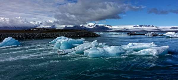
Iceland is a landscape that is a miniature example of all possible stages of development of the planet Earth. Here you will find beautiful mountains, active volcanoes, geothermal areas, geysers, interesting rock formations, canyons, wild rivers, countless waterfalls and also picturesque towns and settlements.
Jökulsárlón lagoon
Ice beauty
Jökulsárlón is the largest lagoon of its kind in Iceland. It was created by the melting of the Breiðamerkurjökull glacier. The lagoon is only 76 years old. It is filled by ice floes that have loosened from the front of the glacier. The kilometer-long river Jökulsár, the shortest river in Iceland, flows out of it. continue reading


Dettifoss waterfall
Europe's mightiest waterfall
Waterfall Dettifoss (100 m wide, 44 m high) in river Jökulsá is most massive European waterfall. Only a few hundred meters further down the basalt columns falls the smaller Selfoss and t Dettifoss Waterfall (100 meters wide, 44 meters high) on the river Jökulsá at the deserted north of Iceland is Europe's most massive waterfall. Only a few hundred meters further down is the smaller Selfoss waterfall and two kilometers further south to look out of the Hefragilsfoss waterfall. continue reading

Godafoss Waterfall
God's waterfall
Near the small settlement of Fossholl, the icy blue river Skálfandárfljöt, rising from the south of Vatnajökull glacier, flows quickly in basalt horse-horseshoe canyons through a pair of cataracts. The larger one is Goðafoss, where Ϸorgeir (the interpreter of the laws of historic Alsace, in year 1000 decided that Christianity is to be Icelandic official religion) destroyed pagan sculptures and tossed them into the waters of the waterfall. continue reading


Gullfoss Waterfall
The golden waterfall
Gullfoss is located on the Hvita River. It falls in a double cataract into a two-kilometer long canyon set between the basalt-like organs. The first cataract is revealed completely, rolling 10 meters forward, then the river bends sharp at 90 degrees and falls another 20 meters into the shadow of the gorge. The waterfall is the nicest in the late afternoon, when the rays of the sun set on the water streams. continue reading

Brennisteinsalda
The most colorful peak of the Rainbow Mountains
Brennisteinsalda, „Burning Mountain“, is not high, its peak is located only at an altitude of 881 m above sea level. The slopes of the mountain play with a variety of color shades. Lush green, just above the Grænagil gorge, with a black stream of obsidian lava and red, ocher, yellow and white below the summit. continue reading

Lake Frostastadavatn
Lake near the Rainbow Mountains
The beautiful Lake Frostastaðavatn lies on the edge of the Námshraun lava field, near the rift interface in the outskirts of Landmannalaugár. Fjallabak runs past it, an unpaved inland road that ends in a campsite at the „Rainbow Mountains“. Locals like to go trout fishing here. continue reading

Skogafoss waterfall
Iceland Waterfall curtain
Skogafoss belongs to most photographed Icelandic waterfall, where water falls from former offshore cliffs. Today it is five kilometer far from the sea. From here leads trail over the pass to the valley Fimmvörðuháls Porsmork (about 23 kilometers altitude 1000 meters). You can see here amazing scenery and dozens of other waterfalls. continue reading

Glymur Waterfall
The highest Icelandic waterfall
Glymur is the highest Icelandic waterfall. Its water falls from a height of almost 200 meters from the swampy basin on the western side of Lake Hvalvatn. Demanding waterfall trail leads up the Botnsdalur valley at the end of Hvalfjörður. continue reading

Fjadrárgljúfur Gorge
The most famous Icelandic gorge
Fjaðrárgljúfur gorge with difficult pronounceable name, located in the south of Iceland near the Kirkjubæjarklaustur area. It is 100 meters deep and about 2 km long, the river Fjaðrá flows through it. The canyon was created for centuries by the gradual erosion caused by the glacial river flowing through the Palagonite rocks. continue reading

Raudhólar Volcano
Red volcano
Rauðhólar volcano (209 m above sea level) is located in the northeastern part of Iceland, in the Jökulsárgljúfur National Park. From its top (to which the ascent is limited due to nature protection) there is a wonderful view of the middle course of the river Jökulsá á Fjöllum. The volcano is considered one of the most colorful on the island, its slopes play with different shades of red, ocher, yellow and gray-black. continue reading

Herdubreið
Queen of the Icelandic mountains.
Herðubreið with a height of 1682 m above sea level is the most significant Icelandic volcano. It is located in the interior of Iceland. Nearby is a small green oasis Herðubreiðarlindir, which is a nature reserve. At the foot of the mountain there is a shelter where the famous Icelandic bandit Fjalla-Eyvindur lived, who survived the harsh winter of 1774–1775. Icelanders consider this volcano to be their national mountain. The ascent to the volcano is less difficult, but it requires more special equipment – a helmet and in the period from October to 1/2 June also cats and ice ax. continue reading

Kirkjufell
The most photographed mountain of Iceland
Between the towns of Grundarfjörður and Ólafsvík, on the Snæefell Peninsula, lies the 463-meter high Kirkjufell Mountain. The mountain together with the nearby Kirkjufellfoss Waterfall creates a beautiful scenery and is one of the most frequently photographed places in Iceland. continue reading

Kristínartindar
Scenic peak in Skaftafell National Park.
Kristínartindar (1126 m above sea level) is a mountain rising between the slides of the glaciers Vatnajökull, Skaftafellsjökull and Morsárjökull. From the Sjónarnípa lookout point, a beautiful view of Iceland's highest mountain – Hvannadalshnjúkur – opens up. Elevation gain about 1100 m. Starting point – camp Skaftafell. continue reading

Dynjandi waterfall
Roaring waterfall
Not far from Arnafjörður is the most impressive waterfall of the West Fjords. Dynjandi falls from a 100-meter-high rock cliff into the fjord waters of the Dynjandisvogur bay, forming a triple cascade of 30 meters wide at the top, 60 meters wide at its lower end. Under the main cascade you can see five smaller cascades diverting the Dynjandis River into the sea. continue reading

Gatklettur Rock Gate
Basalt gate at Arnarstapi
Anyone who parks a car in Arnarstapi by a huge stone troll has no idea what a fantastic rocky shore awaits him. At the foot of the volcano, Snæefell revealed a surf of volcanic chimneys in the form of pillars, caves and gates, whose lava solidified in the shape of hexagons. These rock formations provide ideal living conditions for colonies of various seabirds. continue reading

Icelandic Western Fjords
The rugged and deserted northwest of Iceland
The peninsula of the northwestern Iceland is wild, rugged and full of beautiful nature. Dozens of fjords surrounded by majestic rocks and hills flow into the tip of the promontory, on which is the country's fifth largest glacier, Drangajökull. Thanks to the mountainous landscape, these areas are very rarely inhabited, and the best seafood can be tasted in local villages and settlements. continue reading

Selfoss Waterfall
Lesser known brother of Dettifoss waterfall
Close to the famous Dettifoss Waterfall, a mile uphill downstream, there is another interesting waterfall – Selfoss, with long, but only 10 m high cascades, which create an interesting funnel. The waterfall is also interesting by the fact that the visitor can easily reach the immediate vicinity of the falling water. continue reading

Kerid Crater
Colored Crater
Kerið was probably formed three thousand years ago during a sudden explosion of underground gas, leaving a neat conical hill whose crater is 70 meters deep and 70 meters wide. The crater floor is flooded and used for fish farming. Along its red gravel edge with views of the neighboring Seyðishólar crater, an unpretentious 15-minute trail leads. continue reading

Icelandic Eastern Fjords
The easternmost part of Iceland
The eastern fjords, the easternmost part of Iceland, are far from being the most visited. Nevertheless, they have their unmistakable charm. To the east of Iceland, these are long beautiful fjords and pleasant green plains, to the south a glacial landscape and to the northwest a volcanic landscape. One of the most beautiful places in the area is the deserted fjord Mjóifjördur, with many waterfalls, rock formations and lighthouses. continue reading

Seljalandfoss waterfall
Waterfall sold land
At the western edge of Eyjafjöll, road 249 deviates north from the motorway and continues on to Ϸórsmörk. A few meters away is Seljalandsfoss, translated Waterfall of the Sold Land, a narrow but powerful waterfall falling directly down the slope into a shallow lake. Directly behind the water curtain of the waterfall are the paths where the sound of falling water is most impressive. continue reading

Cliffs of Látrabjark
The westernmost tip of Europe
Látrabjark, the bird cliffs with the Bjargtangar lighthouse, are the westernmost point of Europe (excluding the Azores) and certainly the westernmost point and building of Iceland. They stretch in a 14 km long belt, so they are also the longest bird cliffs in Europe. The path leads along the top of the cliff and offers incredible views of thousands of seabirds. Alkanes, alcoves, cormorants, roaches, gulls and puffins nest here. continue reading

Mountain Skeidárarsandur
Icelandic Mordor
The Skeiðarársandur plateau, an area plagued by frequent sandstorms, lies below the Skeiðarárjökull glacier. In 1996, the eruption of the Grímsvotn volcano destroyed the whole area. The eruption melted much of the glacier and sent down three trillion liters of water rolling in a five meter high wave that swept away 7 km of road and demolished several bridges. From the plain there is a view of the highest peak in Iceland, Hvannadalshnjúkur. continue reading

Lake Myvatn
“Mosquito“ lake.
The area around the lake, located about an hour from the town of Akureyri, is rich in thermal springs and volcanic formations, and there is also a geothermal spa. The weather here is much drier and sunnier than in other parts of Iceland and for almost two summer months it hardly gets dark here. On the other hand, in the winter months there is a harsh and dark winter, accompanied by heavy snowfall. The waters of the lake itself are relatively shallow. Its area is 38 km2 and the maximum depth is 4.5 m (average only 2.5 m). It lies at an altitude of 277m. It fills an old glacial basin blocked by a lava stream. The water has a beautiful blue tint and is clear. The river Laxá flows north from the lake to the Greenland Sea (length 58 km). About 50 volcanic islands and islets, separated by craters, protrude above the lake surface. They are 20 to 30 m high. There are a lot of fumaroles on the east coast. The lake has been the object of various slanderers since the Middle Ages, when it was considered a lake of the devil's urine, even with its smoking surroundings. Mývan in translation means mosquito lake. You won't find many mosquitoes here, but flocks of small black flies will attack your eyes and noses, which are very unpleasant, but usually do not bite, and their larvae provide an abundance of food for fish and thousands of birds that breed their young near Mývno. All duck species found in Iceland nest here or near the sharp salmon of the Laxá River, which flows out of the lake. Flocks of trout and alpine grayling swim in the waters. continue reading

Heimskautsgerðið (Artic Henge)
Icelandic modern Stonehenge
Heimskautsgerðið (Artic Henge) is a stone building near Raufarhöfn, the northernmost settlement in Iceland. Building on Icelandic and Norwegian mythology, the construction began in 1996. It is a kind of newly built monument for the pagan worshipers of Asatru and will serve as a huge sundial and solar calendar upon completion. The bases are basalt columns, forming four large gates, corresponding to four seasons and the fifth gate in the middle. continue reading

Pass Fimmvördusháls
View of Eyjafjalla volcano
The over 20 km long route from Skógar through the Fimmvörðuháls pass, between the Eyjafjallajökull and Mýrdalsjökull glaciers, and then down the other side to Ϸórsmörk, is a really pleasant and beautiful route thanks to the surrounding landscape and relative accessibility. The highest point on the route is the Fimmvörðuháls pass (1043m) with the Fimmvörðuskáli mountain hut. continue reading

Hraunfossar Waterfall
Lava waterfall
Hraunfossar and its smaller neighbor Barnafoss are two waterfalls belonging to the most famous natural wonders of Iceland. Both are formed on the river Hvítá. Hraunfossar (Lava Waterfall) offers a little better experience. It is not a roaring influx of foamy white water, but gentle cascades of clear turquoise water, coming from beneath a layer of moss overgrown with moss and falling down rows of stone cascades into the river. continue reading

Cliffs of Dyrhólaey
The southernmost part of Iceland
The series of jagged cliffs lining the strip of black sand is an amazing place for sea observation and is also an important reserve of seabirds. Every nook and cranny in the cliffs is inhabited by seabirds from April to winter, whose presence is unmistakably revealed by guano splatters. Not far from here lies the town of Vík-í-Mýrdal, Iceland's southernmost settlement and the Reynisdrangar – Trolí skály rock needles. continue reading

Svartifoss Waterfall
Black Waterfall
Svartifoss, the Black Waterfall, is located in the Skaftafell National Park. It is one of the most interesting waterfalls in Iceland. Named after the dark hexagonal columns over which water flows, it was the inspiration for the architectural project of the National Harpa Theater in Reykjavik. continue reading

Skaftafellsjökull Glacier
Glacier below the highest mountain in Iceland
Skaftafellsjökull is a 10 km long and almost 2.5 km wide glacier slide in the southeast of Iceland. It is located in Skaftafell National Park, between Skaftafellsheiði in the west and Hafrafell in the east. The Hvannadalshnúkur peak rises above the glacier, which is the highest point of Iceland at 2,119 meters. continue reading

Gunnuhver thermal baths
Interesting geothermal field
In the southwestern part of the Reykjanes peninsula lies the geothermal area Gunnuhver, with a number of mud volcanoes – mofet and fumarole. The uniqueness of the space is multiplied by the noise of boiling water, the force of escaping steam and the pungent smell of sulfur. The uniqueness of this area also lies in the fact that the groundwater here is 100% seawater, which is nowhere else on the island. The steam temperature here can reach up to 300 ° C. continue reading

Svínafellsjökull Glacier
The most active glacier slide
Svínafellsjökull is the most active glacier slide of the Vatnajökull glacier. It is easily accessible by a short hike along the trail from Skaftafell National Park. continue reading

Strokkur
Geysir's little brother
Srokkur Geyser (Máselnice) spouts a 30m high stream every few minutes. Just before the explosion, the surface of Strokkur Lake turns into a dome for a fraction of a second, which is ruptured in an instant by an exploding water column. After decades of inactivity, the earthquake in 2008 set in motion the neighboring more well-known Geyser, but the eruptions are very irregular (Geyser spews a column of water to a height of 70 m). continue reading

Vatnajökull Glacier
The largest Icelandic glacier
Vatnajokull is a glacier located in the southeast of Iceland. It is the largest glacier of the country and the second largest in Europe (just after Austfonn glacier in Spitsbergen). With an area of 8100 km², it covers roughly 8–10% of the island's surface. From its edges, about 20 glacier splashes are triggered. The name Vatnajökull is composed of the name Vötn – lake and jökull – glacier (Icelandic). continue reading

Krafla
Active volcano over Lake Mývaln
An active central volcano with an altitude of 818 meters with numerous craters dominates the whole area. The caldera, about 10 kilometers wide, was formed 100,000 years ago, as evidenced by numerous formations of rhyolite tuffs. In the recent past, it was active from 1724 to 1729, most recently from 1975–1984. The caldera is crossed by a north-south fault system, which is the cause of all volcanic activity in the region. continue reading

Grábók Vulcan
Neighbor of Grábrókarfell
Right next to the small town of Bifröst you will find two small volcanoes Grábók and Grábrókarfell. It's easier to ascent Grábok in twenty minutes. Views from the top of the neighboring Grábrókarfell are definitely worth it continue reading

Rjúkandifoss waterfall
Waterfall just off the road
In the northeast of Iceland, just off the main ring road number 1, you will find the picturesque Rjúkandifoss waterfall. You will reach it simply on the footpath continue reading

Fjallsárlón Lagoon
Lagoon in the shade of the more famous Jökulsárlón
At the southern end of the giant Vatnajökull glacier, there is the Fjallsárlón lagoon. Thanks to the fact that the well-known Jökulsárlon lagoon is not so far from here there are only few tourist here. It is also very beautiful continue reading

Námafjall
Pastel volcanic landscape
Námafjall is a very interesting volcanic area. Pastel volcanic ridge is surrounded by bubbling fumarolas and small black lakes. The place itself is well accessible – it is right next to the main ring road. continue reading

Lón Valley
Wide valley of a glacial river
The Lón Valley is the valley of the glacial river Jökulsá á Lóni, whose 30 km wide estuary is framed by Vestrahorn and Eystrahorn, two distinctive granite massifs rising in the west and east. Central Jökulsá á Lóni is a typical glacial stream and its wide bed is intersected by intertwining springs, shallow and crystal clear in winter, dark in summer, massive and fast flowing, nourished by melting snow. continue reading

Lake Singvallavatn
The largest lake in Iceland
Nine thousand years ago, when rolling lava blocked the outflow of springs, a 14 km long lake was created, the largest in Iceland. It has a single outflow, the Sog River with three hydroelectric power plants. There are three small islands of volcanic origin. Abundant flocks of trout regulate insect populations. The adjacent flooded gorge Silfra was evaluated as one of the best places for deep diving in the world. continue reading

Dragon stones in Höfði
Interesting rock formations
Höfði, a small grove on the southern shore of Lake Mývan, is one of the most beautiful parts of the whole area. Stack-like formations (dragon stones) and small islands jutting out of the crystal clear water attract birds and the coast is lined with meadows full of flowers and birches. Ice divers, small divers and Icelandic woodpeckers nest here. continue reading

Skápadalur beach
Shipyard
Skápadalur is one of the many beaches along the Patreksfjörður Fjord, which is the southernmost of the Western Fjords. The local attractions are numerous shipwrecks trapped on the beach or sunk in a fjord. The most famous is the shipwreck Garðar BA-64. The whole area was named after St. Patrick, who was the spiritual guide of Örlygur Hrappson, the original settler in the area. continue reading

Homestead Thjódveldisbaerinn
Viking settlement
Not far from the Hekla volcano, in the valley of Thjórsárdalur, lies the small homestead Torfhof Thjódveldisbaerinn. The homestead is an example of how the Vikings once lived. Beautiful beautiful surroundings and the homestead itself are an ideal place for bivouacs. continue reading

Lóndrangar Rocks
Rock pillars
The Lóndrangar rock pillars, located on the Snæfellnes peninsula in western Iceland, rise from the sea just behind the Malarrif lighthouse. The more powerful of the two pillars reaches a height of 75 m and is called the Christian pillar, its smaller neighbor is called a pagan pillar. Both are remnants of a basalt cone that once stood here. continue reading