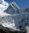
Hike across Kongma la pass
Across The most beautiful pass in Khumbu


Surprisingly not frequently walked shortcut from Lobuche to Chhukhung over Kongma la pass (5 528m asl.) with stunning views of the throne of the gods Makalu.
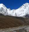
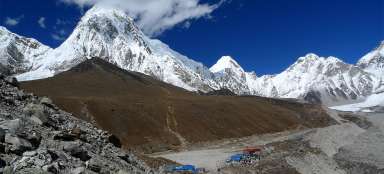
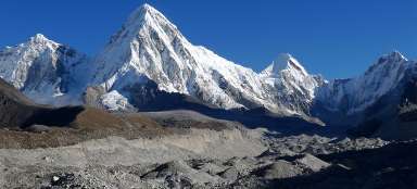
Lobuche from the moraine
Frequent morning fog over Lobuche usually fortunately dissolves with the first rays of the sun, which is ideal for the start of tours to Chhukhung. At the beginning you rise as if diagonally in the southeast direction towards Khumbu glacier moraine, which also serves as a nice outlook to Lobuche.

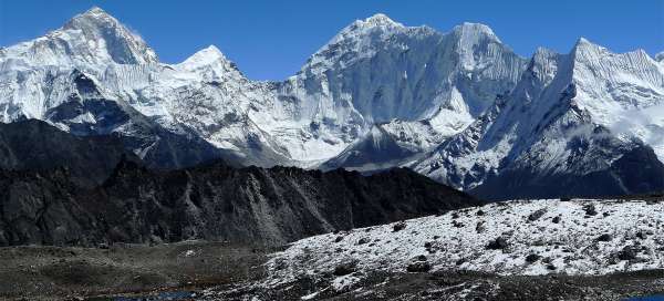
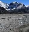
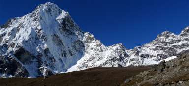
Khumbu Glacier
After the ascent to the moraine you have no other choice but to go over more than six hundred meters wide Khumbu glacier. It is fortunately no problem to hold to the path, but in some parts it would have been really awkward in the fog. However, a few people have been lost here in bad weather already. The last beautiful views of Pumori and the whole couloir of surrounding mountains open from the glacier highway. Kala Patthar really looks insignificant from here.

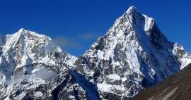
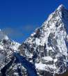
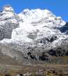
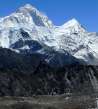
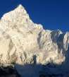
Cholatse and Taboche
On the other side protrudes gorgeous spike of Cholatse a Taboche.

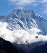
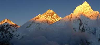
A look back at Cho Oyu
Most of the tourists curse on the edge of the moraine how many needless meters they have to descent again. The following way to the path depends strongly on the physical condition. Fearfully slope hill, but without technical pitfalls. Along the way gurgle the rivulet from the remnants of mountain Pokalde glaciers, so there is no problem to refill water on the way. During the rest breaks you can enjoy the more and more panoramic views of the village Lobuche and the jagged Lobuche mountain with several peaks beyond. This is typical example that nepalese ranking to „trekking peaks“ does not suggest anything about the difficulty of the ascent. It is in fact typical climbing ascent. Then a „mezzanine“ follows, which is ideal for a snack. From here appears the further continuation of the path significantly worse.

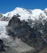
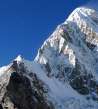
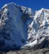
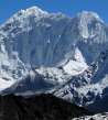
Pokalde (5 806m asl)
The side with our pass looks like quite a perpendicular barrier and there is a steep debris slope in front of us. Fortunately, it's actually not so hot – there are quite nice twists leading over debris slope. Pokalde with its double tops (5806 m asl) and (5741 m asl) tower in the right.

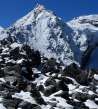
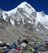
Just under the pass
Even for well-acclimatized tourists is the sharp ascent at 5,500 meters with a backpack quite demanding. The last few dozen meters are the worst – rising through the stone field, already covered with icy snow. So up here, just close to the peak, you should be slightly careful where you tread. Fluttering flags and promised incredible views, on the other hand, motivate a lot to finish this ascent.

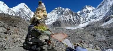
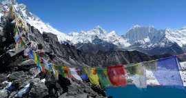
Kongma la (5 528m asl)
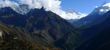
Beautiful view from the pass almost knocks the tourist to his knees… Unbelievable mountain panorama shows off from north to south: Lhotse (8516 m asl), Lhotse Shar (8,383 m asl), Makalu (8463 m asl), Baruntse (7,220 m asl), Ama Dablam (6814 m asl) and many others.

Wonderful views from the pass
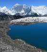
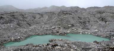
This beautiful scenery complements the vast blue lake only a few tens of altitude meters under the pass. You can ask the question here, why almost nobody goes that way, when the outlooks are almost comparable to those from Kala Patthar.

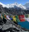
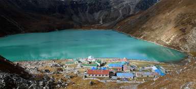
Three lakes
Right from the pass rises sharp small ridge to the main peak Pokalde (5806 m asl), which also belongs to the Nepalese official list of „trekking peaks“. But people who are going there mostly do not arrange the permission, because there is no one to check it anyway. But easier way to the top does not lead from here, but from the lake. Further ascent path leads also from it around the rest of Kongma glacier to the top of Kongma Tse hill (5820 m asl).

View to the valley Niyang Khola
A long descent to Chhukhung starts with ninety vertical meters descent through the steep slope to the beautiful nameless lake (5434 m asl), which belongs among the lakes in the highest location the world. The amazing power of nature here represents a lone flower blooming between stones. Behind the lake there is a field break. From here it is possible to see how the path twists into severe distances and depths directly against pronounced mountain handsome Ama Dablam.

Nuptse and black couloir
You descent through wide valley that was shaped by the gigantic glacier. Descent is really quite endless. Landscape becomes slightly friendlier over time. Behind a combination of black, by the glacier smoothed rocks and something like almost meadows rises a gigantic side of Nuptse, which seems slightly drab compared to other mountains in the area. It is ideal to take a pleasant rest by the small waterfall.

Ama Dablan
You still descent through the valley directly opposite king of the mountains Ama Dablam, around whose top clouds are flying in a large. It is very beautiful performance. Only the way to Bibre (4570 m asl) is drawn in the map, which would be about additional 160 vertical meters of descent and then again ascent to Chhukhung. Fortunately, you can turn to the traverse path, which crosses three arms of the former Nuptse glacier flowing from the Nuptse mountain, and reach your destination more comfortably. The way takes together with admiring in the pass and rest breaks around 7.5 hours. And it is only about 11 km, 700 up, 900 down. From the orientation point of view it is definitely better to go from Lobuche than vice versa. Even in the season there are days when you do not meet here a living soul even for the whole day.

Articles nearby


Article: Three passes BC Everest Trek
Trek over three passes (Renjo la, Cho la and Kongma la) leads you through more challenging, but very beautiful and far less… continue reading
Giga List: The highest tourist ascents
Many enthusiastic tourists are attracted by hikes that lead to high mountains or mountain passes, but do not have climbing… continue reading
Giga List: The most beautiful stages of the trek to Everest
The highest mountain in the world, Mount Everest, is located in Sagarmatha National Park, located in the Khumbu mountain region.… continue reading