The most beautiful ascents in the Ötztal Alps
The best of mountain hiking in the Ötztal Alps

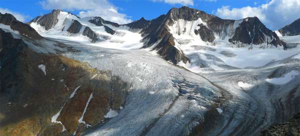
The Ötztal Alps offer hundreds of 3,000 peaks accessible from three main valleys: Ötztal, Pitztal and Kaunertal. It is literally a paradise for climbers and alpine tourists. Be inspired by the most beautiful mountain tours in the area
Ascent to the Wildspitze and descent through the Taschachtal
Two-day skiing in the Pitztal
Winter ascent to Austria's second highest mountain Wildspitze (3,772 m.) Crossing the Taschachferner Glacier from east to west and then descending Taschachtal all the way down to the car park. First step. A ten-kilometer drive from a glacier lying at an altitude of 3,200 m. To a valley at an altitude of 1,700 m. continue reading


Ascent to Similaun
Trek to mythical mountain
Similaun (3 606 m asl) is one of the most popular and highest mountains in Austria. Moreover, it is not very difficult, so a number of tourists ascend here every year. And there is no wonder – there is not only fabulous view from the top, but also the way itself from the valley is very nice. In its vicinity are also a number of other peaks, so you will not be bored in his area even for a few days. This trip describes the ascent on snow in the early spring. continue reading

Ascent to Kreuzspitze
Awesome outlook around Ötztal
Kreuzspitze (3455 m asl) belongs among the highest easily accessible austrian hiking peaks (you do not need any climbing equipment for the ascent). There are really incredible views across the whole Ötztal in good weather from its top. You can manage the ascent in one day from Vent, but far more enjoyable and tactical is to sleep at the hut of Martin Busch Hütte and combine it with another ascent in the neighborhood. continue reading

Ascent to Hohe Geige
To the highest mountain Geigenkammu
Hohe Geige (3,395 m above sea level) is one of the most accessible hiking mountains in the Ötztal Alps, thanks to which it is one of the most visited peaks, although it does not reach such fame as the Kreuzspitze near Vent. For a challenging climb on it, especially if you make it in one day, you will be rewarded with amazing views of all corners of the world. The most classic ascent is from the Pitztal valley through the Chemnitzer Hütte. The march from the Chemnitzer cottage to the top of the mountain describes this photo report. continue reading

Ascent to Karleskopf and Polleskogel
March opposite the glacier arena
The hike from the Braunschwaiger Hütte mountain hut to the Karleskopf and Polleskogel hills is a short yet amazing view. However, if you have this as a day trip from Mittelberg „at the bottom“ of the Pitztal valley and back, it will definitely take you. A short detour leads to Karleskopf (2,902 m above sea level) from a relatively pleasant mountain path leading to the Pitztaler Jöchle saddle (2,996 m above sea level) – the starting point for a short ascent along cracked stones to the top of Polleskogel (3,032 m above sea level). continue reading

Ascent to Sulzkogel
The outlook over Finstertaler Stausee
From Kühtai Pass ( 2017 m asl ), which lies on the mountain road that connects the Ötztal valley with Sellraintal, starts a wonderful tourist trail to the great dam Finstertaler and then on to the top of Sulzkogel ( 3016 m asl) or alternatively via Finstertaler Scharte ( 2777 m asl ) to the valley Horlachtal. continue reading

Ascent to Hohe Geige via Westgrat
Plangeross - Gahwinden - Westgrat - Hohe Geige
The ascent from Plangeross to Hohe Geige in one day is quite challenging, but in good weather it can be managed. However, it is advisable to leave early in the morning. If you do not want to chase too much, but want to enjoy the views and take pictures along the way, it is necessary to take into account that the hike will take about twelve hours. In addition, if you want to stop at the Rüsselsheimer Hütte, the hike may take even longer. continue reading

Ascent to the Pitztaler Jöchl and Polleskogel
Amazing view to the ice arena
The best of this moto trip around Ötztaler Gletscherstraße is a short ascent to the pass Pitztaler Jöchl (2990 m asl), from where is an amazing view of the ice arena closing smaller, but more dramatic valley of Pitztal. In the distance towers above all this the highest mountain in Tyrol – Wildspitze. Just above the pass is a small peak with rock fractured by the glacier – Polleskogel (3032 m asl). Pitztaler Jöchl is also a tourist connection of Ötztal and Pitztal valleys – so the place where tourists undertake multi-day treks in the Ötztaler Alps. continue reading

Ascent to Marzellkamm
Half-forgotten outlook to Similaun
Nice half-day walk begins at the mountain hut Martin Busch Hütte and leads to two kilometers long ridge Marzellkamm dividing two impressive glaciers flowing down from the local most favorite mountain of Similaun. The way is not too crowded, because there are far higher mountain targets around. And the outlooks on the way are really impressive. In addition, photographers can stay here without any problems until sunset, because the journey back to the moutain hut is not difficult and long continue reading

Ascent to Saykogel from the east
Connection between two valleys
You can ascent Saykogel by two ways – either from the Niedertal or Rofental valley. Most of the tourists take this advantage and plan the circuit not to have to return back through the same valley. So the mountain does not serve just like a beautiful outlook, but also as an interesting connection of hiking paths. Extreme tourists can do this circuit in a single day from Vent. Most tourists, however, go with more comfortable pace and spend one or two nights in this area. This photoreport describes the way from Martin Busch Hütte to the top of the mountain. continue reading

Hike across the pass Finailjoch
Journey on the glacier Hochjochferner
Crossing of the pass Finailjoch (3 280 m asl) below the mountain Finailspitze (3 514 m asl) is no longer a classic trekking trip, since you can expect long descent on the glacier Hochjochferner. At the end of winter is relatively walkable by snowshoeing or only in hiking boots, but you must still take into account that the risk of falling into ice crack is present also at this time. Anyway, it's a very nice way to Rofental valley with views of Similaun and far into the Italian Alps. continue reading

Ascent to Saykogel from the west
Above the glacier arena
Ascent to Saykogel is possible in two ways – either from the valley of Niedertal or Rofental. Most of the tourists do not make use of this not so common option in the high mountains and plan the circular trip not to have to return back through the same valley. So the mountain does not work just as a beautiful outlook point, but also as an interesting conjunction of hiking trails. Extreme tourists can do this circuit in a single day from Vent. However, most tourists walk in much more relaxing pace and spend in this area one to two nights. This photoreport describes the way from Hochjochhospiz to the pass where the path leading from the east to the top of the mountain joins. continue reading

Ascent to Parstleswand
Plangeross - Parstleswand - Kaunergrathütte and back
Parstleswand (sometimes also called Portleswand) may not be as attractive at first glance as some other and even higher peaks in the area. But climbing it is definitely worth it. Apart from a few more demanding sections, it is not too difficult. If you go to the Kaunergrathütte hut and back to Plangeross, the hike will take about 11 hours at a leisurely pace. continue reading


Ascent to Mittagskogel
Mittelberg - Mittagskogel and back
The Mittagskogel can be reached from Mittelberg relatively easily using the Gletscherexpress tunnel, which takes you to a height of 2,840 m above sea level. From here, it is just over 300 meters above sea level to the top of the Mittagskogel. However, a more valuable performance is to complete the entire ascent on foot. The hike is not very technically demanding, but due to the relatively large elevation gain, expect a total time of about eleven hours. continue reading