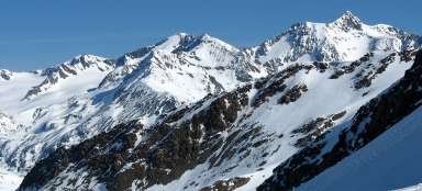
Ascent to Saykogel from the west
Above the glacier arena


Ascent to Saykogel is possible in two ways – either from the valley of Niedertal or Rofental. Most of the tourists do not make use of this not so common option in the high mountains and plan the circular trip not to have to return back through the same valley. So the mountain does not work just as a beautiful outlook point, but also as an interesting conjunction of hiking trails. Extreme tourists can do this circuit in a single day from Vent. However, most tourists walk in much more relaxing pace and spend in this area one to two nights. This photoreport describes the way from Hochjochhospiz to the pass where the path leading from the east to the top of the mountain joins.
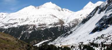
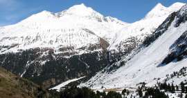
View of the valley Rofental
The first part of the walk is pretty obvious from this point of view: From the chalet Hochjochhospiz (2412 m asl) you must descent more than 100 altitude meters to the bridge over the fierce creek of Hinteriesbach. And then ascend the same vertical meters to this outlook. Therefore the vast majority of tourists who crossed the mountain from the east and are not going to sleep in Hochjochhospiz, do not ascend to it and descend along a little-trodden path through valley Rofental directly along the creek.
Hut Hochjochhospiz is also the starting point for many other hiking trails such as the top of Mittlere Guslarspitze (3128 m asl), hut Vernagthütte (2755 m asl), hut Schöne Aussicht Hütte (2842 asl) and many others.

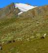
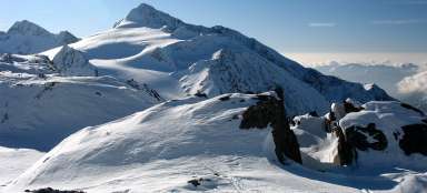
The outlook of Mutspitze
Warm lawn at the outlook invites you to relax. You can see from here not only the hut Hochjochspitz, but also smaller peak of Mutspitze, behind which the most icy part of the entire Ötztal Alps begins.

“Crossroads” Saykogel - Schöne Aussicht
At 2470 meters above sea level there is “crossroads” of paths. Those who ascend to Saykogel cross here the stream of Hochjochbach and begin to ascend up the valley. The others have still about 5 km left to the hut Schöne Aussicht lying already in Italy. The starting point of this tour – Hochjochhospiz is still visible on the horizon.

Creek Hochjochbach
Creek Hochjochbach is quite fierce – especially in the afternoon on sunny days, when a lot of water flows from melting glaciers.

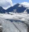
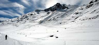
The gradual ascent
The ascent is initially only slow without any twists up to the big stone cairn, which is a good point of reference, especially during bad weather. From here the winding path begins to rise up through the endless rocky slopes – remnants of glaciers. The landscape is barren and almost depressive.

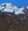
View of Wildspitze
The number of views extend after two hours walk from Hochjochhospitz and increasing height – you can nicely see the highest mountain in Tyrol – Wildspitze.

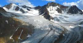
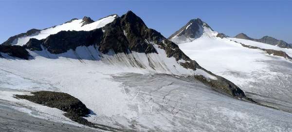
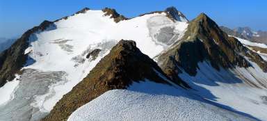
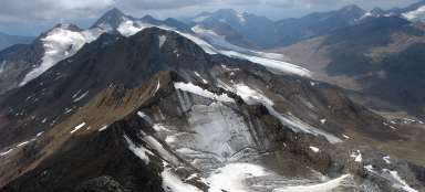
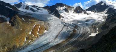
Finailspitze (3514 m asl)
Finally, there is the intersection at the ascent ridge – about 3,000 meters above sea level. Climbing path leads to the glacier and is heading to the pass of Finailjoch (3280 m asl). Other tourists continue with the ascent to Saykogel. There are beautiful views from the ascent ridge, especially in the south direction to „ice world“, from which rises a large black pyramid of Finailspitze.

Awesome views
The outlooks are really worth the effort.

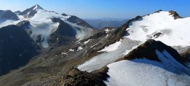
Finailspitze and Hauslabkogel
Because the final ascent has a ridge character, there are still beautiful views to both sides. On the other hand, this trip is not suitable for people with dizziness and without a certain step.

View to the northwest
Also on the other side of the ridge there is an ice field called Kreuzferner, but it is much smaller.

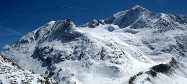
Ascent ridge
Ascent ridge in all its glory and lined with glaciers on both sides. High vertical slopes on each side – the most demanding passage of the whole crossing of this mountain.

The top pass
After about 3.5 hours of ascent we are in the pass only a few meters under the own mountain top. Finally, we see also the beautiful Mount Similaun on the other side.
Now there are two options – go back to the hut Hochjochhospiz and descend back through the valley Rofental or „cross the mountain“ and walk down to the hut Martin Busch and through Niedertal valley to Vent.

Articles nearby


Article: Hiking in the valley Rofental
Rofental valley in Ötztal Alps is popular mainly due to a variety of ascents you can undertake from it. In addition, the canyon… continue reading
Giga List: The most beautiful ascents in the Ötztal Alps
The Ötztal Alps offer hundreds of 3,000 peaks accessible from three main valleys: Ötztal, Pitztal and Kaunertal. It is literally… continue reading