Article Ascent to Marzellkamm
Half-forgotten outlook to Similaun


Nice half-day walk begins at the mountain hut Martin Busch Hütte and leads to two kilometers long ridge Marzellkamm dividing two impressive glaciers flowing down from the local most favorite mountain of Similaun. The way is not too crowded, because there are far higher mountain targets around. And the outlooks on the way are really impressive. In addition, photographers can stay here without any problems until sunset, because the journey back to the moutain hut is not difficult and long
Bridge over creek Niederjochbach
From the hut Martin Busch Hütte you need to go through the lower path to the bridge (2527 m asl) over a stream Niederjochbach (about 300 m walk), which significantly simplifies its overcoming towards the ridge Marzellkam. In the background towers Vorderer Diemkogel (3368 m asl), to which does not lead any hiking trail.

Valley of the stream Niederjochbach
View up the valley Niederjochbach, through which leads a very popular way to the hut Similaun Hütte on the main Alpine ridge dividing Austria from Italy.

Meadows under Marzellkamm
Meadows nearby the hut are far more romantic for a snack than crowded terrace. In addition, there is a greater chance to meet a sheep than a tourist.

The outlook to Martin Busch Hütte
Immediately at the beginning of the hike it is possible to see that the hut stands at the crossroads of footpaths. There is mountain entertainment at least for three days.

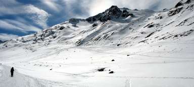
Niedertal valley
During the ascent you pass the labeled turning (2612 m asl) for climbers heading to mountain Hintere Schwärze (3624 m asl). After about an hour of steeper ascent through winding paths there are views as from the bird’s eye view. Directly to the north stretches a long valley of Niedertal, so at one glance you can see 90% of the access path from Vent to Martin Busch Hütte.

At Marzellkamm
Some passages of the ridge (approx. 2800 m asl) are pleasantly wide, covered with grass – ideal for relaxation after the first stage of the ascent or while waiting for the sunset relatively close to the hut. The view in this direction is to the icy Hauslabkogel (3402 m asl), a small pyramid of Saykogel (3355 m asl), through which leads a very interesting crossing to the valley Rofental and Sennkogel (3400 m asl).

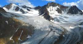
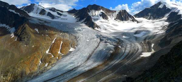
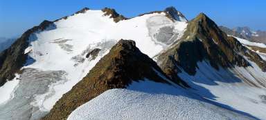
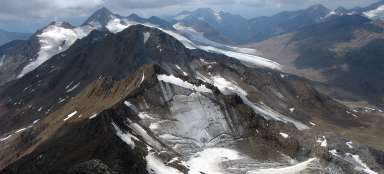
Mountains above Marzellferner
The most beautiful views from the hike are to the glacier Marzellferner and the surrounding high mountains.

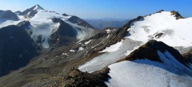
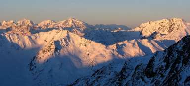
Similaun (3606 m asl)
Above all towers massive Similaun.

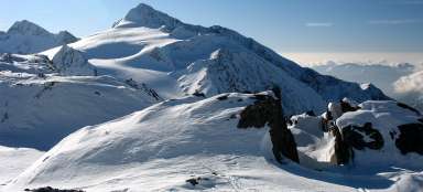
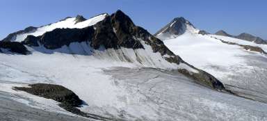
Patra Marzellkammu
The ascent along the ridge continues as if on the floors on which sheep occasionally graze. On the far right is a slightly glaciated Shalfkogel (3,537 m above sea level).

Romantic view of Similaun
Some places, especially in the late afternoon, are really worth stopping and admiring their beautiful scenery.

Final traverse
Just close to the top begins the toughest part of the ascent, where you traverse the debris slope. It is basically the only challenging place on the hike /view back on the whole traverse of the fractured part of the ridge/.

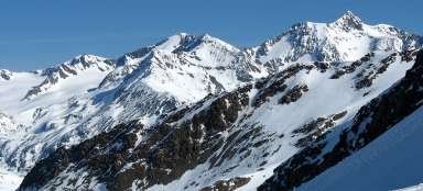
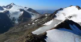
Marzellkamm (3147 m asl)
After more than 600 vertical meters from the hut Martin Busch Hütte and 2–3 hours you are finally on the top of the ridge with a shaky cross and a fancy view of the surroundings. On the left there is Marzellspitze (3522 m asl) and on the right a little higher Similaun.

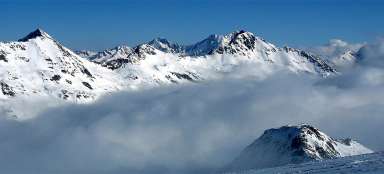
Similaun Hut
From the top of Marzellkamm there is a nice view of the Similaun Hütte (3010 m asl) strategically located on the border ridge just above the glacier. You go back along the same path, about 2 hours. For those who did not start from the hut, but already from Vent or return back there, it's a nice whole day trip.

Articles nearby


Article: Hiking in the valley Niedertal
Niedertal valley is one of the most beautiful valleys in Ötztal Alps. It is dominated by beautiful Similaun (3 606 m asl) and… continue reading
Giga List: The most beautiful ascents in the Ötztal Alps
The Ötztal Alps offer hundreds of 3,000 peaks accessible from three main valleys: Ötztal, Pitztal and Kaunertal. It is literally… continue reading