Article Ascent to Parstleswand
Plangeross - Parstleswand - Kaunergrathütte and back


Parstleswand (sometimes also called Portleswand) may not be as attractive at first glance as some other and even higher peaks in the area. But climbing it is definitely worth it. Apart from a few more demanding sections, it is not too difficult. If you go to the Kaunergrathütte hut and back to Plangeross, the hike will take about 11 hours at a leisurely pace.
Lussbach Falls
A suitable starting point can be Plangeross, or a small car park between Plangeross and Weisswald, as well as for climbing the opposite Hohe Geige: [https://www.gigaplaces.com/…es-westgrat/] . In both cases, you must first cross one of the footbridges to the other side of the Pitze river and join the marked path leading around the Lussbach stream towards the Kaunergrathütte (Parstleswand itself will only appear on the signs at the last crossroads below the summit). The road leads at the beginning with a steep slope between the trees. After climbing about 150 meters, the first (and largest) waterfall will appear. Gradually the trees dwindle, the road is no longer so steep. At the next waterfall, it crosses to the other side of the stream. Just above the footbridge is a small cottage, probably used mainly by cowherds. However, it is possible to buy something to drink here with a little luck (in the morning there was a sign in front of the cottage offering drinks and on the roof of the cottage stood a local shepherd and with binoculars supervising cows in the area, when returning in the late afternoon the sign was cleaned ).

Rest area
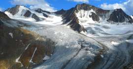
Above the cottage, a beautiful valley gradually opens up in front of us. It is bordered on the left by the peaks of Hoher Kogel and Seekarlesschneid, on the right by the slopes of Parstleskogel and far ahead rises the double peak Watzespitze (also known as Waze), with an altitude of 3,532 m is the highest peak of the Kaunergrat. The trail is now comfortable, with only a small climb to the crossroads at an altitude of about 2,180 m above sea level. Here we will continue straight on, still towards the Kaunergrathütte.

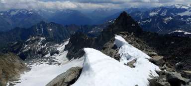
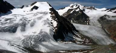
View of the Geigenkamm
We have to climb another three hundred meters of altitude to the next crossroads. At the crossroads, the trail splits in two, both leading to the Kaunergrathütte. We will continue along the path turning right, which can be reached, among other things, to Lake Mittelberglesee. Just above the crossroads is a smaller plain with a cottage (probably also a shepherd's), from which there is a nice view of the opposite ridge Geigenkamm, headed by the highest Hohe Geige.

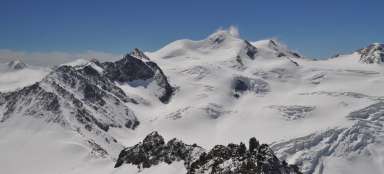
The first saddle
The road continues to the saddle at an altitude of about 2,700 m above sea level, from where there is a wonderful view in all directions – towards the Mittelberglesee, the Geigenkamm and especially the Parstleswand and Watzespitze. The route to Mittelberglesee is also separated here. We will continue to the Kaunergrathütte hut, from which, according to the indicator, we are still 2 hours apart (but without counting the turnoff to Parstleswand).

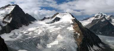
Mainzer See
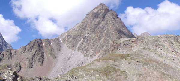
From the saddle we descend again by less than 100 meters to the small lake Mainzer See directly at the foot of Parstleswand. It may not seem so completely in the photo, but in reality the peak looks quite menacing from here, until one begins to doubt a little whether it is not a destination for climbers rather than for ordinary tourists.

Steinbockjoch saddle
A little behind the lake follows the first slightly more difficult section, secured in the most difficult place by a chain. However, the steep climb through the wall is relatively short and after overcoming it, the comfortable path continues again with beautiful views to the Steinbockjoch saddle at 2,960 m above sea level, where there is another crossroads, finally with a sign to Parstleswand, which is the last 30 minutes. The pointer shows, but surprisingly, the path to the top is not marked. At the beginning there is a clear footpath, but it soon ends and there is only a „pile of stones“ in front of us. Sometimes a stone little man can be seen somewhere, indicating a suitable direction, later even the little men don't help anymore. Fortunately, the direction to the top is clear and soon a wooden cross at the top can be seen.

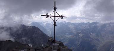
Peak - 3,091 m above sea level
The last part of the ascent (and then the descent) is the second slightly more demanding section. It is necessary to be careful where to step, sometimes to help yourself with your hands, but in good weather and with a little caution there is no greater danger. There is not much space at the top, but the views are beautiful and it is worth staying for a while and enjoying them. The same way – we return to the Steinbockjoch saddle. With good visibility, this is not a problem, the saddle is still visible below us, but in heavy fog it could be quite an adventure due to the absence of markings.

Cottage Kaunergrathütte
After returning to the saddle, we continue to the Kaunergrathütte hut. The road descends a steep slope and runs quickly. In the last part, ropes are secured in several places. During the summer season, it is possible to eat or stay here. In the low season, a small cottage next door should be freely accessible (no guarantee).

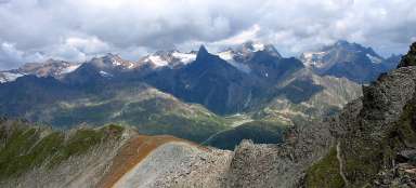
Return to Plangeross
From the cottage it is possible to climb to the Plangerosskopf viewpoint, or to the Madatschjoch saddle, however, as part of a one-day tour, it would probably be difficult to catch up. So we continue down, towards Plangeross and after about 1.5 km we get back to the crossroads near the small cottage, where we turned right at the exit. Returning to the parking lot or to Plangeross is from there on the same road around Lussbach as we climbed up.
Articles nearby
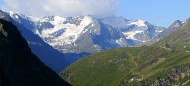


Giga List: The most beautiful ascents in the Ötztal Alps
The Ötztal Alps offer hundreds of 3,000 peaks accessible from three main valleys: Ötztal, Pitztal and Kaunertal. It is literally… continue reading