Ascent to Hohe Geige via Westgrat
Plangeross - Gahwinden - Westgrat - Hohe Geige


The ascent from Plangeross to Hohe Geige in one day is quite challenging, but in good weather it can be managed. However, it is advisable to leave early in the morning. If you do not want to chase too much, but want to enjoy the views and take pictures along the way, it is necessary to take into account that the hike will take about twelve hours. In addition, if you want to stop at the Rüsselsheimer Hütte, the hike may take even longer.
From Plangeross to Rüsselsheimer Hütte
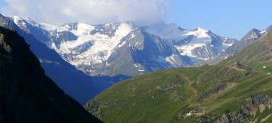
The most convenient place to start a day trip to the Hohe Geige is the town of Plangeross. If you are not staying directly in Plangeross, it is possible to leave your car in the small car park between Plangeross and Weisswald, from where your own journey to the Hohe Geige begins. The first section to the Rüsselsheimer Hütte (formerly Chemnitzer Hütte) should take about 2 hours, according to the indicator, and it is quite believable. The cottage is located at an altitude of 2,323 m above sea level and the elevation of the road from the parking lot is a little over 700 m. From the cottage is a beautiful view of the opposite ridge.

From Rüsselsheimer Hütte to Gahwinden
It is possible to ascend the Hohe Geige in two ways – along the so-called Normalweg or via the Gahwinden viewpoint and further along the Westgrat road. On the sign by the cottage, both roads are marked in black (difficult). The journey along the Normalweg should take 3.5 hours, the journey along Westgrat 4 hours – in my experience a very optimistic figure, more able tourists may be able to do it in that time, but they will probably not have time to enjoy the trip. The crossroads are up to about 800 m behind the cottage. The Normalweg has reportedly not been recommended lately due to falling rocks, so at the crossroads I turn left to the Gahwinden viewpoint. The road is pleasant here, without a steeper climb. On the lookout, at an altitude of 2,647 m above sea level, there is a wooden cross and, perhaps a little surprisingly, a wooden bench. An ideal place to relax in front of the most demanding part of the route.

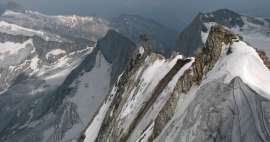
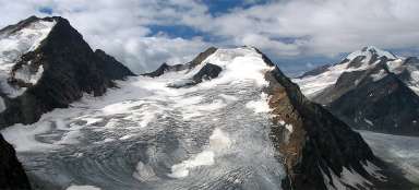
Westgrat
For the first few tens of meters, the path is still relatively easy, but soon stones, rubble, rock blocks begin to appear and the paved footpath disappears irretrievably. Hiking poles are starting to get in the way rather than to help, and it is better to fasten them to a backpack and free your hands, which will be more and more needed when climbing. The photo (looking back down) shows the ridge along which the road leads.

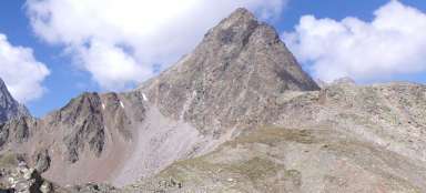
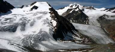
Top in sight
The very top of the Hohe Geige is not visible for a substantial part of the way, until after ascending to higher positions it finally appears (a more distant peak with a strip of snow).

Continuation after Westgrat
However, the most challenging section of the road is still ahead of us. The Westgrat road continues along the ridge, which is relatively narrow in places. There are steel ropes in several more exposed places to increase safety. I would not recommend this path very much for people suffering from dizziness.

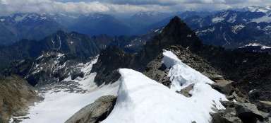
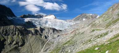
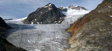
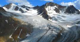
Glacial lake
Below the top of the Hohe Geige is a small glacial lake. However, at the end of August 2019, there were no monuments on the lake. Not much was left of the „iceberg“ either. The water flowed between the stones straight into the interior of the rocks. At this point, the Westgrat and Normalweg roads connect again. The absence of a pond facilitated the last part of the ascent. Instead of bypassing the remains of the „glacier“ on the right side, where the standard road leads, it was possible to go straight along the shortest path.

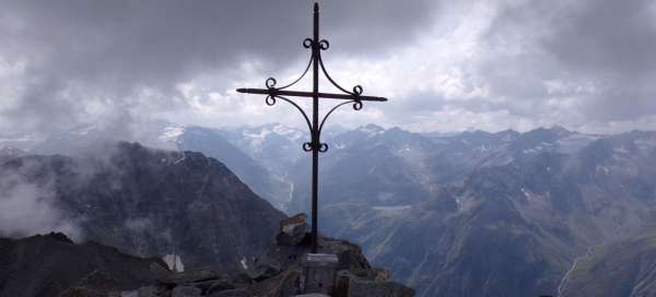
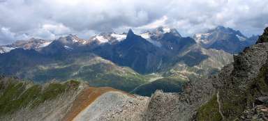
View from the top
The journey from Plangeross to the top of Hohe Geige took about 7 hours. The weather worsened a bit, but there were still beautiful views from the top. At the top cross is a box with a book, according to which there were 3 other people in front of me that day (plus maybe a few others who did not sign up).

Descent on Normalweg
Due to time constraints, I chose Normalweg for the way down, despite the alleged danger of falling rocks. I saw several people on it from a distance, so I risked it too. I can't tell if the danger is real, no stone has fallen during my descent, but several small stone avalanches have fallen from the opposite slope of the Puitkogel during the day. The descent along the Normalweg is quite challenging, very steep and seems endless. But still a little easier than descending Westgrat.

Return to Plangeross
Once the steepest part of the Normalweg is behind us, the journey to the Rüsselsheimer Hütte is no longer difficult. Then descent to the parking lot. From here it is only a short walk to Plangeross.
Articles nearby


Giga List: The most beautiful ascents in the Ötztal Alps
The Ötztal Alps offer hundreds of 3,000 peaks accessible from three main valleys: Ötztal, Pitztal and Kaunertal. It is literally… continue reading
Giga List: The most beautiful mountain ascents in Austria
Austria offers countless amazing mountain ascents, you will also find thousands and thousands of mountains here. Let's take a… continue reading