Hike Plangeross - Chemnitzer Hut
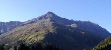
Warm-up stage in front of Hohe Geige

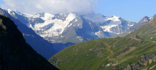

Plangeross (1,615 m above sea level) lies just a few kilometers before the end of the Pitztal valley. This town is an excellent starting point for many tours. One of them is the ascent to the mighty Hohe Geige (3,393 m above sea level), to which the ascent leads through the mountain cottage Chemnitzer Hütte (2,314 m above sea level). This march to the cottage is also nice, but of course it is more like a warm-up round before the very ascent to the main destination of this trip – Hohe Geige.
View of Plangeross
The tour itself begins in the car park between Plangeross (500 meters from the town) and Weisswald. In case of emergency (if you come here very late) you can also sleep here in the car. From the parking lot you can see the dominant peak above Mittelberg – Mittagskogel (3,159 m above sea level), which is possibly a possible and easier destination for the next few days.

View of the Lussbach valley
The actual ascent to the Chemnitzer Hütte hut leading above the Kitzlesbach stream valley is quite tiring and monotonous – the trail zigzags here and there over the steeply rising valley. However, the views of the mountains on the opposite side are worth it. From the beginning, only lower peaks such as Steinkogel (2,632 m above sea level), Brandkogel (2,676 m above sea level) and many others are visible.

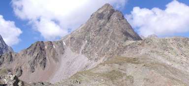
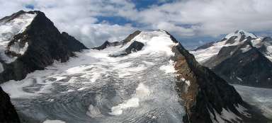
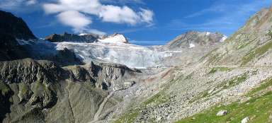
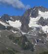
Panoramic views of the Watzespitzi
Practically the entire ascent to the Chemnitzer Hütte has a view only to the opposite valley around the river Lussbach (there is also a very nice hiking trail with a possible transition to the Kaunertal). Over time, however, this view is constantly improving and it is increasingly dominated by the highest mountain of the ridge Kaunergrat – Watzespitze (3,533 m). The ascent very early in the morning is also worth the reason that you are walking up a steep hill in the shade and you have a view of the gradually illuminated landscape.

View towards Rifflsee
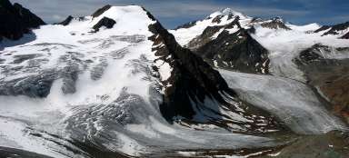
Over time, the view begins to open towards the former glacial moraine, behind which is hidden the beautiful lake Rifflesee.

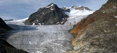
Under the cottage Chemnitzer Hütte
After a two-hour faster walk, the Chemnitzer Hütte mountain hut will finally appear above you, a place with a great view of the opposite Watzespitzi.

Crossroads at Chamnitzer hütte
If you have Hohe Geige as a one-day destination, you will not spend much time at the cottage due to the time-consuming nature of this tour. However, most tourists do not go to the cottage until late in the afternoon, they sleep here and the ascent to the top is easy. However, Hohe Geige is not the only way to hike from this cottage. An interesting option is the ascent to the Weißmaurachjoch saddle (2,953 m above sea level), from where you descend further into the Pollestal valley, which is one of the large side valleys of the Ötztal. This is one of the routes used by tourists who make multi-day crossings of the Ötztal Alps. In addition, a very interesting, partially secured ridge route leads from this pass just over several peaks to the Rettenbach / Tiefenbach ski area at the end of the famous Ötztaler Gletscherstrasse. Another route leads north, the so-called St. Leonharder Höhenweg.

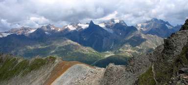
Great view from Chamnitzer Hütte
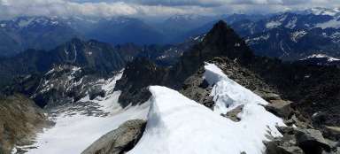
Enjoy the beautiful views of the dominant mountains of the Kaunergrat before you gain strength to continue the ascent to the Hohe Geige, which is still more than a kilometer above you.