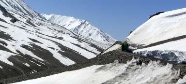
Drive across the Lachalung la and Nakeela
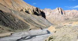
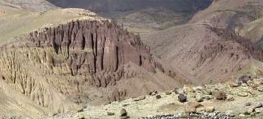
Through the area full of canyons and cli


Leh – Manali road II.part: Road from Pang to Sarchu leads right through two high passes – Lachalung la (5 066 m asl) and Nakeela (4 920 m asl). The way leads thorugh beautiful canyons and there are fairy weathered rocks around. Near rather the promontory than pass Nakeela la is a great outlook into the depths of the canyon and the best known switchbacks on this road „Gata loops“. The remaining part of the journey from the tent camp Sarchu leads already in wide valley of river Tsarap, which is one of the main sources of second largest river of Ladakh – Zanskar.
Beautiful canyon
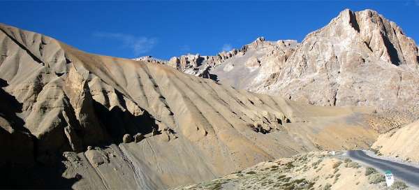
The road from Pang (4 500 m asl) rises in very nice side valley surrounded by weathered rocks. Many people consider this ascent up to the pass Lachalung la for one of the most beautiful parts of the road from Leh to Manali.

The path through the ravine
Originally relatively broad valley quickly turns into a narrow gorge, through which you will ascend into the pass.

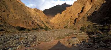
Ravine at Pang
The road had to really be shot into the ravine, how narrow it is in some places. Around you will be plenty of dramatic rock formations.

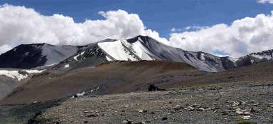
Flat valley
The ravine ends as it began. The area suddenly opens and the river that was wild a moment ago suddenly flows relatively sluggishly between flat eroded hillsides full of small rocks.

Lachalung la
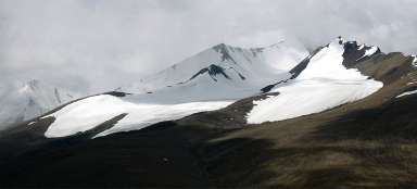
You will finally arrive to relatively insignificant Lachalung la pass (5,066 m asl). There is necessary bollard with height shown in feet, prayer flags and views of the distinctive jagged mountain.

“Jagged” mountain
The most typical view from the pass is of the „Jagged“ mountain at about 5,600 meters asl, from which could theoretically be a very nice view. But the ascent would not probably be a typical hike.

Path to Nakeela
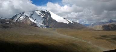
From Lachalunga you will descend in five long switchbacks to the bottom of the valley (only about 300 vertical meters) and you will then drive more or less in traverse of the hillsides of „Jagged“ mountain, which looks from close like a fortress. Most vehicles you meet here are panting trucks. The road is improved every year and it is thus quicker. Years ago, there was mostly gravel road, now there are a lot of asphalt sections.

Nakeela
The highest point in the slope of “Jagged”mountain is called Nakeela Pass (4 920 m asl), although it is pretty far from the classical pass.

Looking back to pass Lachalung la
There are dozens of rock cairns around the half pass Nakeela. Looking back you can see the road twists and completely on the horizon also the pass Lachalung la. This way between these two passes is one of the less interesting passages on the journey from Leh to Manali.

View into the canyon
Behind the pass Nakeela open in a while the views of the deep canyon, on the opposite hill of which you will see the old trail winding upward in endless bends.

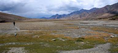
Valley of river Tsarap
From Nakeela await you the descent of more than eight hundred meters of height to a large valley of river Tsarap – one of the major sources of river Zanskar. It is possible to walk to Zanksar along Tsarap on long and by tourists practically not walked trekking route. Before you will be famous switchbacks Gata loops.

Gata loops
Gata loops with its 21 switchbacks are among the most popular places for bikers on the entire road.

Shortcuts of twists
A lot of drivers jeeps do not want to drive through the long twists of Gata loop with low slope projected mainly for trucks and so they made small shortcuts along the gravel paths. So you may enjoy a bit of adrenaline during the descent.

Final way to Sarchu
After running down the twists you get within reach of river Tsarap (approx. 4 180 m asl), which is the lowest place after many hours of driving. From here you will ascend again, so this journey can be recommended really only for well acclimated individuals. Otherwise, you may experience it with a headache or even worse symptoms of mountain sickness.
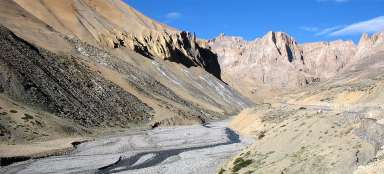
You will drive along the river a few kilometers before you see the tent camp of Sarchu on the horizon. Here leave Jammu and Kashmir and drive into Himachal Pradesche, although boundary marker was surprisingly already in Pang.
But before you come to Sarchu (4 300 m asl), you will have to make nearly seven-kilometer long detour into the canyon Tsarap before you finally come across a bridge over the river and get to the other side.

Sarchu
Sarchu works not only as a tent town, where you can sleep and eat, but also as a checkpost where you will spend some time before they enter you name in a huge book.
From there await you only the crossing of the pass Baralacha la and thus the main ridge of the Himalayas.

Articles nearby


Article: Along the road from Leh to Manali
Long road between Leh and Manali overcomes five very high passes. The highest of them – Taglang la (5 328 m asl) is also one of… continue reading