Treks through the volcanic landscape through the misty forest
Tenerife is famous for its beautiful nature. Outside the volcanic center with the mighty Pico de Teide, you will find huge cliffs and gorges in the Teno Mountains and a beautiful wild coast and misty forest in the Anaga Mountains. Many of these wonderful places are also accessible by hiking trails, so you can take a visit to Tenerife very actively.
Ascent to Pico del Teide
Ascent to the highest mountain in Spain
Pico del Teide, currently an inactive stratovolcano 7,500 meters high (from the bottom of the Atlantic; the tenth highest in the world) is the highest mountain on the island of Tenerife and at the same time the highest peak in Spain with an altitude of 3,718 m above sea level. 1) a two-day ascent with an overnight stay in the cottage (Refugio Altavista) 2) comfortable with a cable car. continue reading
Hike in Barranca Masca
In the grip of volcanic rocks to the oce
Masca Gorge begins in the village bearing the same name. Most ordinary tourists overcome the 600 meter descent to the ocean, from where they will be taken by pre-arranged boat to one of the nearest tourist centers. But Masca is not only about going down and back. In the narrow ravine of the gorge, which is hemmed by several hundred meters high rocks, there is a microclimate even without any breeze and water supply is a must. You will be rewarded by fantastic views of the rock formations, beautiful bay and good feelings from the hike, which is shown in guides as one of the most difficult in Tenerife. continue reading
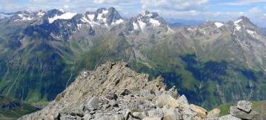
Crossing over the Pico Viejo
The best in the volcanic landscape
This hike is very tempting, because it takes you almost to the top of Pico de Teide (possibly up to it), guides you through the chaotic terrain of lava flows and makes you acquainted with the incredible landscape of monumental crater of volcano Pico Viejo drowsing on the foot of higher stratovolcanic Teide. There is a cableway leading to this highest peak of Tenerife and the whole Spain and it ends at a height of 3 555 meters asl. Another possible way to get there (except for the alternative ascent to Pico de Teide, for which is necessary a permit) continues with the descent. But its length and terrain is quite challenging. The descent ends at the parking lot at Parador Nacional de las Canadas hotel at an altitude of approximately 2 100 meters asl. continue reading
Hike to Monte Taborno
Matterhorn of Tenerife
This peak, reminiscent by its shape uniqueness of a little iconic Swiss mountain, is not high – it has only 706 meters asl, But it lies close to the ocean and therefore gives very monumental impression. It is located in the northern part of the island in the mountains of Anaga. Also the access to it along the ridge separating deep valleys is very attractive. Another route that bypasses gradually the peak offer magnificent views of mountains, valleys and cliffs in the north of Tenerife. continue reading
Hike through the Barranco del Río gorge
Wonderful acquaintance with the Anaga mountains
The Anaga Mountains in the NE part of Tenerife are full of deep gorges, steep cliffs and diverse vegetation. Although the Barranco del Río area is one of the most popular with tourists, it is usually not overcrowded, as in the whole of Anaza. At least for now. continue reading
Hike to Tafada Mountain
In the very north of Anaga
The area around the northernmost village of Chamorga is a real paradise for trekkers. There are a number of interesting trails that will take you into the dense vegetation of the foggy forest and great viewing places, from which you can see the wild coast of the Anaga Mountains. continue reading
Ascent to Cruz de Gala and Pico Verde
Beautiful hike in the Teno mountains
There are many interesting places in the Teno Mountains. However, the ascent to the peaks of Cruz de Gala and Pico Verde is one of the hikes that bring beautiful circular views and, moreover, there are not as many tourists as, for example, in the more famous locality – the Masca gorge. continue reading
Ascent to Guajara
An inconspicuous peak
The ascent to this 2,718-meter-high peak begins at the Cañada Blanca information center, while the descent continues to the village of Vilaflor. In total, it will climb less than 600 meters during it, but then it is necessary to descend by 1,400 meters. The route, with a total length of approximately 16 kilometers, passes through several vegetation zones and is also interesting from a geological point of view. continue reading
Tour Chamonga - Benijo
Coastal trek closed trail
A closed but even more beautiful trail on the island of Tenerife passes along the northwest coast from two small villages from Chamonga to Benijo, the whole route is about 10 kilometers long and can be managed in about 3 hours, why so long? Because, as I mentioned, the road is closed, it leads along the coast and there are several sections where you need to be very careful. continue reading
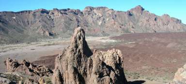
Hike around Roques de Garcia
Hiking near God's finger
For most visitors, Roques de Garcia is just a view of the Pico de Teide over the Rock of God's Finger. However, you can also take a very pleasant walk around this entire volcanic ridge with rock towers. continue reading
Ascent to Refugio de Altavista
Ascent below the highest mountain in Spain
The ascent to the highest mountain in Spain – Pico de Teide (3,718 m above sea level) is undoubtedly one of the most classic hikes you can take in Tenerife. Surprisingly, this hike is not overcrowded, as most visitors to the mountain use a cable car, which will take them to a height of 3,550 m above sea level. However, you do not have to worry that at the top it will be like a market place. Most of these visitors who take the cable car do not know that the final ascent to the summit needs to be registered in advance and will only remain on the sightseeing circuit below the summit. The hike itself will take you through a bizarre volcanic landscape with amazing views across the island. This first stage of the ascent leads from the car park to the Refugio de Altavista cottage. continue reading
El Pijaral
A walk through the misty forest of the Anaga mountains
The northern part of the island of Tenerife, specifically part of the Anaga Mountains, has been a UNESCO biosphere reserve since July 2015. It is good for nature protection, but when entering some areas, it is necessary to take into account the need to issue a permit. This also applies to the northernmost ridge of Anaga. The daily number of permits is considerably limited, it is good to use internet applications at least a month before the planned trip. continue reading
On the way from Santiago del Teide to the sea
Along the border of Teno Park between agricultural fields
Santiago del Teide is the most important place of pilgrimage on the island of Tenerife. From here we head southwest. The road will take us to the port of Puerto Santiago and along the coast we will reach the massive rock formations of Los Gigantes. continue reading
Ascent on Montana Reventada
To the foot of stratovolcano through vol
Ascent to Montana Reventada is an ideal acclimatization hike, during which you ascend to a height of 2,231 meters asl. At the same time it may also be the first and very attractive introduction to the volcanic landscape of the island Tenerife. Ideal access path is a road leading to the central caldera from the west from town Guia de Isora. After a relatively quick ascend though the curves appear the view of stratovolcano Pico de Teide and soon also a parking place, which serves as an outlook point. Here is very often overcome the wall of trade wind clouds, which is at altitude around 900 to 1200 m asl. Above them is an amazing world of Parque Nacional del Teide. continue reading
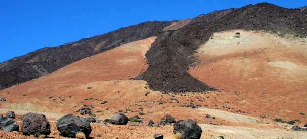
Hike to Las Narices del Teide
Teide´s nostrils
The ascent to the holes, through which used to „breathe“ the stratovolcano Pico de Teide, can be a trial acclimatization hike before walks at higher altitudes. A day spent in sometimes chaotic terrain of this landscape will also offer magnificent views of the western part of central caldera, southwest of the island Tenerife with Teno mountains and neighboring island La Gomera. The level of three kilometers (3 022 m asl) will be overcome during this ascent. The trail then continues up to the crater of Pico Viejo (3 134 m asl), which is an alternative option for a day hike (longer by at least 2 hours). continue reading