Article Langtang Trek
The nearest alpine trek from Kathmandu

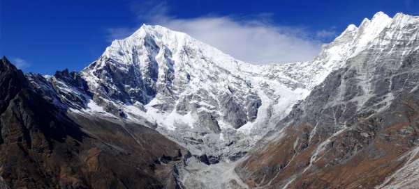

Langtang Trek is one of the most popular treks in Nepal. Thanks to its relative accessibility (by bus from KTM) and length (only about 7 trekking days), even those who have only about two weeks of time to Nepal can go there. The trek leads through the Langtang Khola river valley and from the lush vegetation it takes you to the alpine landscape of ice peaks and weathered hills. There are plenty of loggias along the way, so you don't have to lug camping equipment with you
Day 1 - Trip from Kathmandu and start of the trek
On the first day, a tiring several-hour bus ride along the dangerous road from Kathmandu to Syabros Besi awaits you. If you want to stretch your murdered body, the ideal option is to connect a little more, for example to the Domain, where you will arrive in an hour and a half of comfortable walking.
By bus from Kathmandu to Syabru Besi
Driving along the famous Nepalese road of death
If you want to go on a beautiful Langtang trek, a tiring bus ride awaits you to the starting point in Syabru Besi. The ride takes between 6–9 hours and especially the last part, when driving on an unpaved dirt road high above the valley of the river Trishuli is worth it. continue reading


Trek Syabru Bensi - Domen
The beginning of the Langtang Trek
Langtang Trek Part 1: The beginning of the Langtang trek is in the dusty town of Syabru Bensi, where you get off broken after a many hours drive from Kathmandu. Someone sleeps here before the trek, someone sets out to stretch the body for at least a few kilometers. In the second variant, a good goal is the isolated Domen loggia located less than 5 kilometers from Syabr. The path leads through a green valley with several nice waterfalls. continue reading

Day 2 - From Domain to Gumnachok (Woodland)
The next day you ascend from the jungle to the rhododendron forest and see the glaciated peaks for the first time. You have plenty of options to end the trek, because the loggias are really every 1–2 hours of walking. We recommend going to Gumnachok (Woodland) if you plan to go to Kyanjin Gompa the next day
Trek Domen - Bamboo
Trek through the Nepalese mountain jungle
Langtang Trek 2 part: From Domen to Bamboo (2,010m above sea level) it is only three kilometers, but almost 400 altitude meters. Tourists who go Langtang trek slowly, end here their first day of trek (if it comes from Syabru Bensi). However, if you start in the Domain, it is just a warm-up stage for the day. The path leads through a narrow valley filled with lush vegetation with lots of waterfalls. Along the way, a trek across Lake Gosain Kund joins continue reading

Trek Bamboo - Rimche
Climb the jungle
Langtang Trek 3 part: The ascent from Bamboo to Rimche (2,470 m above sea level) is the first real ascent on the trek. Strenuous, especially when it gets hot in the midday heat. You will climb more than 500 meters on less than three kilometers. During the ascent, the vegetation around you will also change. The Rimche itself is basically two loggias a short distance from each other at a crossroads continue reading

Trek Rimche - Gumnachok
The first views of the ice peaks
Langtang Trek 4 part: From Rimche to Gumnachok (Woodland) (2,800m above sea level) it is about 4.5 kilometers and 370 meters above sea level. The path in this passage still leads through a beautiful forest along the river, but finally with the first views of the glacier giants after the river turns north. Just outside Rimche is the Lama Hotel, where there are a lot of tourists, because there are sleeping travelers both on the way up and on the way back. That's why we haven't slept here once continue reading

Day 3. - From Gumnachok to Kyanjin Gompa
The third day awaits you from the lush forest to the open alpine landscape. You will walk through the worst affected place in the whole Langtang – the town of the same name, which was razed to the ground by the infamous earthquake in 2015. Along the way you will almost always have beautiful views. Already today you can walk to Kyanjin Gompa (3,860 m above sea level). Those who want to add altitude gradually, however, prefer to settle a little lower, either in Langtang (3,450 m above sea level) or in Mund (3,540 m above sea level)
Trek Gumnachok - Ghoda Tabela - Thangsyap
Beautiful views of Langtang Lirung
Langtang Trek 5 part: At this stage from Gumnachok to Thangsyap (3,170 m above sea level) you will finally reach over three thousand meters above sea level. The valley opens beautifully and you will have beautiful views of the monumental Langtang Lirung. In addition, several waterfalls await you. Thangsyap itself lies high above the river continue reading

Trek Thangsyap - Lantang
Journey through the site of the worst disaster
Langtang Trek Part 6: At this stage you will find about four kilometers and 370 altitude meters. The road leads high above the river Langtang Khola and the newly built town of Langtang (3,450 m above sea level) will almost always be visible on the horizon. You will also be waiting for the crossing of a monumental landslide, which buried the entire original village during the earthquake in 2015 and killed 243 people only (41 tourists) continue reading

Trek Langtang - Kyanjin Gompa
Hike to the highest village in Langtang
Langtang Trek Part 7: From Langtang to Kyanjin Gompa it is still 6.5 kilometers and 400 meters of elevation gain. But the climb is quite gradual and there are really beautiful views. If you do not manage to reach Kyanjin Gompa, it is also possible to stay in Mund (3,540 m above sea level) just a kilometer and a half behind Langtang. continue reading

Day 4.-6. - Tours and ascents from Kyanjin Gompa
Kyanjin Gompa is not just the destination of the Langtang trek, but rather a starting point for a number of beautiful tours and ascents of various difficulties. You will also find two difficult mountain passes Ganja la and Tilman pass, thanks to which you can go back another way or a two-day climb to Yala Peak. In any case, whatever plans you have here, count on at least three days for the surrounding peaks. We did the following: – 1 / Ascent to Kiangin Ri with return via Glacier View Point – 2 / Tangbu Pass with a short walk towards Ganja la – 3 / Ascent to Tserko ri with return via Yala Kharku
Ascent to Kyangin Ri
Rock view directly on Kyanjin Gompou
Langtang Trek Part 8: The ascent to Kyangin Ri (4,604 m above sea level) is an excellent acclimatization classic before the ascent to the more famous Tserko Ri (4,985 m above sea level). The ascent route starts directly in the village of Kyanjin Gompa and leads in serpentines directly up first to the rock pulpit Lower Kyangin Ri (4,300 m above sea level) and then even higher to the main peak. The views from both peaks are absolutely amazing and worth the effort continue reading

Descent from Kyangin Ri to Glacier Valley
Alternative descent from Kyangin Ri
Langtang Trek Part 9: Kyangin Ri is a popular acclimatization tour from Kyanjin Gompa. However, most tourists return the same way or just a short distance away. A more interesting and adventurous alternative is to come down to the so-called Glacier Valley and return to the Kyanjin gompa by a little detour. Basically, you will make climbing from Kyangin Ri a relaxing trip for the whole day continue reading

Ascent to Tangbu Pass
Viewpoint on the way to Ganja la
Langtang Trek Part 10: If you want to enjoy a one-day hike in Kyanjin gompa, where you will hardly meet a person and at the same time see the Langtang Khola valley from the other side, be sure to take a trip to Tangbu Pass (4,315 m above sea level). This small pass, however, is not marked in every map (it is not even on mapy.cz). However, it lies on the road that leads to the demanding 5,000-strong Ganja la saddle and it is a really great view. Orientation is especially challenging from the edge of the hike, when you have to hit the right path through the rhododendron forest continue reading


Ascent to Tserko Ri
The highest tourist peak in the Langtang Valley
Langtang Trek Part 11: Tserko Ri (4,985m) is the most popular tourist destination in the Langtang Valley. Although he is 15 meters short of the magical limit of 5,000 meters above sea level, it is still a wonderful view in all directions. Expect 4–5 hours to ascend from the tourist village of Kyanjin Gompy (3,860 m above sea level). You can go back the same way or longer via Yala Kharka continue reading

Descent from Tserko Ri to Yala Kharca
Beautiful return trip to Kyanjin Gompa
Langtang Trek Part 12: Most tourists who climb the almost 5,000-meter Tserko Ri Hill return to Kyanjin Gompa on the same (shortest route). A far more interesting alternative is to go back along the mountain plains of Yala Kharka and then traverse high above the valley of the Langtang Khola river and make a nice sightseeing trip. continue reading

Day 7. - Descent to Rimche
Langtang Trek Part 13: This day you will take a route you have already taken. It is about 19 kilometers to Rimche and about 1500 altitude meters down. Rimche is convenient by turning directly onto the beautiful upper road through Sherpagaon and Khangjim
Day 8. - Upper road through Sherpagaon and Khangjim
On the eighth day of the trek, be sure to take the „upper“ path through the villages of Sherpagaon and Khangjim. wonderful views await you and you will also see the highest mountain of the Ganesh massif – Yangru. In the end, you will only have a long descent back to Syabru Besi
Trek Rimche - Sherpagaon
Hiking on the observation balcony
Langtang Trek Part 14: On the last day of the trek, we recommend not returning with the same path down the valley through Bamboo, but up the top path through Sherpagaon. You will go through beautiful views and you will meet only a fraction of tourists opposite the lower road. The first part of the trekking day is a march to the picturesque Sherpagaon (2,550 m above sea level) continue reading

Trek Sherpagaon - Khangjim - Syabru Besi
View of the Ganesh mountains
Langtang Trek Part 15: The road from Sherpagaon to Khangjim still follows the so-called Nepalese contour, or ascends to a height of 2,730 meters. From the promontory just before the descent to Khangjim (2,275 m above sea level) there is an amazing view of both the Ganesh Mountains and the depths in which Syabru Besi lies, the final destination of this beautiful trek. From Khangjim, you will descend the last 900 meters to Syabru Besi. continue reading

Day 9 - Return to Kathmandu
In the morning, you will be taken by bus back to Kathmandu along the already known road with the vision of eight tiring hours. At least the only advantage is that you will see the sections you saw in the afternoon now in the morning and vice versa
Articles nearby





Giga List: The most beautiful Nepalese treks
Thanks to the highest mountains in the world – the Himalayas – Nepal offers some of the best trekking opportunities in the world.… continue reading