Ascent to Kyangin Ri
Rock view directly on Kyanjin Gompou


Langtang Trek Part 8: The ascent to Kyangin Ri (4,604 m above sea level) is an excellent acclimatization classic before the ascent to the more famous Tserko Ri (4,985 m above sea level). The ascent route starts directly in the village of Kyanjin Gompa and leads in serpentines directly up first to the rock pulpit Lower Kyangin Ri (4,300 m above sea level) and then even higher to the main peak. The views from both peaks are absolutely amazing and worth the effort
Start in Kyanjin Gompa
The ascent begins right in Kyanjin Gompa. There is even a signpost, but you really can't get lost, just by clicking straight up

Exit path to Kyangin Ri
The road itself leads through mountain meadows and is not absolutely technically demanding – the only problem for some may be altitude. The first goal of this ascent – Lower Kyangin Ri is a black rock visible from many places both from Kyanjin Gompa and from this ascent

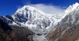
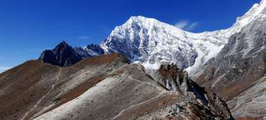
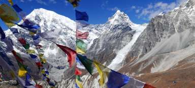
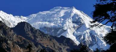
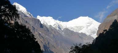
View of Langtang Lirung (7,227m above sea level)
Langtang Lirung is simply a mountain not only of this ascent, but of the entire Langtang trek – you will simply see it a thousand times from different angles and distances. But it's a monumental shield, so it just doesn't look away

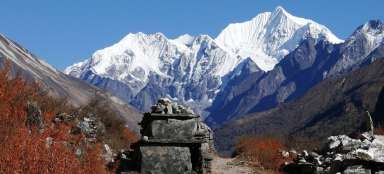
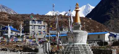
View down to Kyanjin Gompu
From this point of view, it is beautiful to see deep down Kyanjin Gompa and dozens of zigzags on the exit road

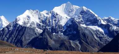
View of Tserko Ri
Behind the two valleys rises the „volcano“ Tserko Ri (4,985 m above sea level), the main tourist destination in the area. The beautiful ice mountain on the horizon is then Ganchenpo (6,300 m above sea level)

Lower Kyangin Ri
After an hour and a half of ascent, we are finally within reach of the stone pulpit – the summit of Lower Kyangin Ri (4,300 m above sea level). You can sit here and enjoy the whistle of prayer flags

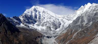
View of Ganchenpo (6,300m above sea level)
Ganchenpo is the second mountain in the Langtang Valley that you will see a thousand times, but its ice wall is really worth it

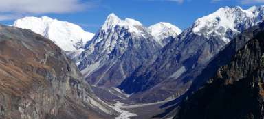
View of a glacial lake
It also opens for the first time a view of a glacial lake at the end of the rest of the Lirung Glacier

Road to the main peak of Kyangin Ri
In front of us is the last 300 altitude meters and a ridge in the Low Tatras – cool :-)

Retrospect
Lower Kyangin Ri is really just such a small rock pulpit. We met only about 10 other tourists here, so definitely no massacre

Ice tip
With increasing height, the views of the previously hidden peaks open up

The road along the edge
At times, the road leads right along the edge from where the weathered slopes fall 500 meters below. This is perhaps the only place in the whole ascent where the tourist should follow the path more so that he does not slip down

Final output
The final ascent looks visually quite interesting, as to the very top of the world – that is, if there were no mountains about a kilometer higher

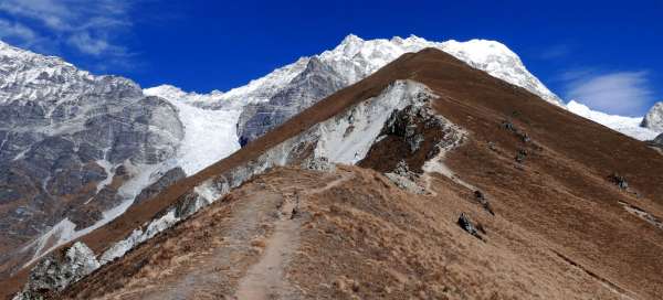
View back to the ascent ridge
The ascent ridge looks quite photogenic both from below and from above

Just below the top
Thanks to the relaxed terrain, even the last meters of the ascent are not twice as strenuous

Kyangin Ri
After about an hour of climbing from the previous peak, you are finally here on Kyangin Ri (4,604 m above sea level)

Views of the Kimshung Glacier
Kyangin Ri is the best view of the largest Kimshung Glacier

Exit path to Tserko Ri
From the top you can see practically the entire ascent path to the more demanding hill Tserko Ri

Descent road
You even have three different options to return, either the same way, or you descend to the saddle to the north and from there down, or you cross the saddle and walk back through another valley, which is also a slightly adventurous variant, but it is definitely worth completing.

Articles nearby


Article: Langtang Trek
Langtang Trek is one of the most popular treks in Nepal. Thanks to its relative accessibility (by bus from KTM) and length (only… continue reading