Ascent to Keprník and Vozek
Circuit through the fourth highest peak of Hrubý Jeseník


Keprník is the highest mountain of the Keprnická hornatina and the fourth highest mountain of the Hrubý Jeseník. The easiest way to get to it is by cable car from Ramzová to Šerák, from where it is only 2.5 km to the top. The journey from Červenohorské sedlo through Červená hora is a bit more demanding and longer. And even more difficult is the journey from Filipovice, which is described in this article. The ascent is part of a circuit in which we will conquer Vozka and Točník and almost Šerák and Červená hora. The circuit is about 22.5 km long and can be reached within 8 hours.
Forest cemetery
Filipovice is located near Bělá pod Pradědem in the direction of Červenohorské sedlo. It is possible to park the car in the large car park of the local ski area, which is almost empty in summer. From the parking lot, we immediately connect to the blue tourist sign, which will take us through the whole village and soon we will dive into the forest. The first section is a pleasant, relaxing walk. The path leads more or less along the contour line or even descends. Only from the crossroads of the Keprnický stream (631 m above sea level) does the ascent begin. Right at the beginning there is a tourist shelter, which is a short detour to the symbolic forest cemetery established after 1960. Near this place was during the Second World War prisoner of war camp, in which in 1941 – 42 36 prisoners of typhus died. In addition, 9 German citizens were buried nearby after the war.

Pod Šerákem
While the first part of the route was an easy walk, the sequel will be a bit more strenuous. We have almost 7 kilometers of continuous ascent ahead of us, during which we ascend almost 700 meters higher. The first part leads parallel to the cycle path along the asphalt road to the Výrovka crossroads. Here we turn right onto a stony path. The section between Výrovka and the following crossroads, Bystrý potok, is probably the most beautiful part of the ascent. The road still climbs up and down in the gorge below us the Keprnický stream roars. At the crossroads of Bystrý potok, we connect back to the cycle path. The section to the Pod Keprníkem crossroads is no longer so attractive, but all the more grueling. At the crossroads, however, we have almost won. The road to Keprník turns left, but it pays to turn right to the tourist cottage in Šerák.

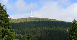
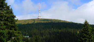
View from Šerák
You can have a snack at the cottage, but also enjoy the nice views. It is a pity that it is not allowed to go directly to the top of Šerák (1,351 m above sea level) (it is located in NPR Keprník – Šerák, where entry is prohibited outside the marked path), even though it lies only a few tens of meters from the nearest marked path. However, the vast majority of tourists will probably not mind.

Hřebenovka
Then we will return to the crossroads Pod Keprníkem, from where we will continue along the red ridge. The trees gradually spread out and the views of the surroundings reopen to us. Looking back, we see Šerák with a tourist hut and the upper station of the cable car.

Twill
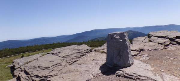
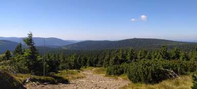
After about 2 km we reach the top of Keprník (1,423 m above sea level). At the top is a small rock – the so-called frost log cabin, which is said to be one of the most beautiful views in the entire Hrubý Jeseník.

View from Keprník
In addition to the Jeseníky Mountains, you can also see Králický Sněžník, the Rychlebské Mountains, and with a little luck you can also see the Krkonoše Mountains or the Beskydy Mountains.

Teamster
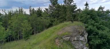
Another destination is the top of Vozka (1,377 m above sea level), from which we are approximately 2.5 km away. We continue along the red road to the Trojmezí crossroads, where we turn right onto the yellow road, which leads us around the peat bogs to the U Vozky crossroads, from which it is only a few tens of meters along the green road to the top, where there is a group of distinctive rocks. Even from here there are nice views of the surrounding hills.

Saddle under Vřesovka
We continue along the green to Sedlo pod Vřesovkou. At first, the footpath descends quite steeply to Hučivá Desná, the next section leads practically along the contour line. Between the thin trees, we see the Red Mountain in front of us, under the top of which there is another target, the Heather Well.

Heather well
In the saddle, we connect again to the red-marked ridge and after less than a kilometer of gentle ascent along the slopes of Červená hora we reach Vřesová studánka. The well is hidden in a small stone chapel built in 1934 (not in 1927, according to some sources). An ideal place for a short stop. The water from the well is pleasantly refreshing and the view is also not the worst.

History of the place
The heather well used to be a relatively important place of pilgrimage. The first wooden chapel was built here probably at the end of the 17th century. It was replaced in 1756 by a new chapel and it was subsequently replaced in 1846 by a stone chapel. However, even that did not last long, and in 1927 the last chapel was opened, but with an even shorter life. In 1946, lightning struck it and it burned down. Another chapel has not been built yet, only in 1993 an iron cross was erected on the site, which survived the fire. And in 2017, an altar stone was placed here. In 1820, a shelter for pilgrims was built here, which later served as an inn. Later, a larger cottage with a restaurant and accommodation was built. After World War II, however, it was nationalized and slowly fell into disrepair, until in 1988 it was demolished despite protests. Today, apart from a small chapel above the well, there is no other building. In recent years, there have been efforts to restore the cottage and the chapel, but so far they have probably failed due to nature conservation.

Red mountain
The red-marked ridge continues to Červenohorské sedlo, but we will continue along the green and after a while we will reach the Červená hora crossroads. However, the peak of Červená hora (1,333 m above sea level) is still about 350 meters away. The peak itself is overgrown with cypress trees and the hiking trail bypasses it, but it is definitely worth making a short detour along the yellow right to a group of low rocks, from which there is a beautiful view of the surroundings.

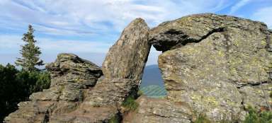
Stone window
Now we are practically just descending to Filipovice. From the viewpoint we return to the Červená hora crossroads and continue along the green. After a few hundred meters we reach an interesting rock formation, a stone window.

Turntable
At the next crossroads, At the Stone Window, take the green traffic. The narrow footpath descends along the ridge to a shallow saddle below the last peak of this route – Točník (1,143 m above sea level). The peak itself is not so interesting, the saddle is only a few meters higher and the view is limited by trees. But there is a slightly steeper descent further along the green, while in one section the footpath twists between the rocks and offers relatively impressive views.

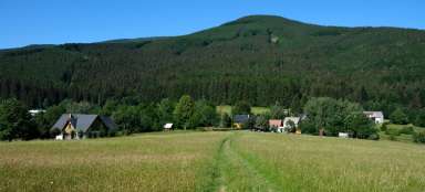
Descent to Filipovice
There are only the last few kilometers to the finish. If we follow only the marked paths, we continue along the green to the crossroads Pod Točníkem, where we turn right onto the blue, which we followed at the beginning and which will lead us to Filipovice. Or it is possible to shorten the path by about 1 km by leaving the green sign on the unmarked asphalt road about halfway down the descent from Točník, from which after a while we turn again to the road leading to the left, down to Filipovice.
Articles nearby


Giga List: The most beautiful hikes in Hrubý Jeseník
Hrubý Jeseník is the second highest mountain range in the Czech Republic and not only for this reason it promises very beautiful… continue reading