Article Allalin design
Three alpine four-thousanders in three days


Ascents above Saas-Fee: Allalinhorn 4,027 m. – via HohlaubGletcher, surprisingly finally to the top and climbing … Strahlhorn 4 190 m. – via Allalingletcher and Adlerpass, endless dance between cracks … Alphubel 4 206 m. – from Mittel -Allalin over Feejoch – a crest parade that we gave up 20 meters before the „bulge“ … unsecured mass of stones moving underfoot … without one helmet … we left this there for the next time and also Fish or Rimpfischhorn 4 199 m, which rises toothy next to the snowy Strahlhorn. Completed July 6 – 8, 2017
Zero Day
Transfer from Bohemia to Britanniahutte
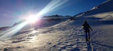
We left Prague very early on Wednesday, already at four o'clock in the morning, there are four of us in the car, the ideal number not only for the car, but also for the glacier expedition. Our destination is the Swiss town of Saas-Fee, or rather Britanniahutte, a chalet located at an altitude of 3030 m above Sass-Fee. In Furka we were a little surprised by the train, it is necessary to either cross the mountain serpentines above the Oberwald, or drive to the train axle and fly through the tunnel for twenty minutes. Apparently it's faster, so we choose option B. In Sass-Fee, we're on time, just in time to catch the last cable car up (I wish the parking lot was closer), which will take us to Felskin. From there we traverse about an hour to the cottage, of course we loaded the bags nicely, quite unnecessarily also with food, because the food at the cottage is excellent, as we find out the same evening. We have booked half board, without it the cottage cannot be booked. I take one fork to comb my hair because I forgot the comb and after four days I am threatened with dreads. Tomorrow we will have an alarm clock at four, our first four thousand in front of us.
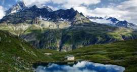
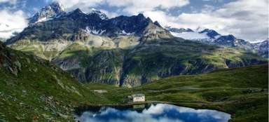
Britanniahutte
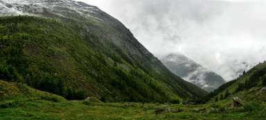
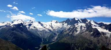
View from the west, from the Hohlaubgletcher glacier.

Day first"
Ascent to Allalinhorn
There was solid rumraj in the cottage from two in the morning, so getting up at four wasn't a problem at all. Under the headlights, we set off slightly down the fifth path from the hut directly to the cracks of the Hohlaubgrat, we crawl the cats, we connect and start to climb. Somewhere at an altitude of 3200 m. Below Allalinhorn towards Mittel-Allalin, my helmet rests, which inadvertently fell off me and then slid irreversibly a few hundred meters. We climb further and just below the top (contour 3880) a rock of about fifty meters awaits us, climbing about difficulty 3, in addition, equipped with security, a pleasant diversification. Above the rock we get back to the snow and the cats, in front of us is the last about a hundred meters and we are already there, on a short plain at the top cross. We decide whether we go back and go looking (probably in vain) for the helmet, or we take the standard route – with several groups of top „tourists“ – to Mittel-Allalin and finally the second option wins and we have beer and tea at 3500 m. mountain subway station. The whole restaurant turns slowly so that people can enjoy it. We are immediately forced to take the subway to Felskin, the pedestrian way down is closed for an incomprehensible reason, it costs us every 26 CHF. From Felskin we continue through the famous traverse to the cottage.
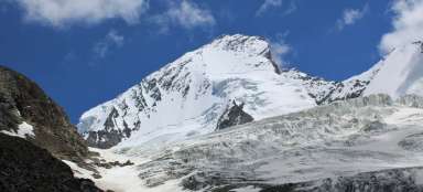
View of the Allalinhorn from Hohlaubgletcher
From here it is still more than five hundred meters up. Just below the top you can see the rock that needs to be overcome.
View from the top of Allalinhorn
… with the Matterhorn in the background

Day "Second"
Ascent to Strahlhorn
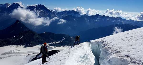
This time we set off before the fifth, well-known path down from the cottage to the west and then further south, through Allalingletcher to Adlerpass. Tied up and in cats, we become champions in overcoming glacial cracks (we saw maybe hundreds of them that day), avoiding dangerous sections of snow and zigzagging over ice and rocks. Everywhere on the ground there are flat green stones – granite splinters, often in combination with quartz bubbles … (Markéta, don't collect the rubble :-D) the way up to the Adlerpass, on the right side the towering Rimpfischhorn, a rocky ridge in the shape of a fish-back that goes from the west and we speculate where the group we met has already climbed. Along the way, we decided to try to drill a glacier screw in a convenient place and verify its load-bearing capacity as a stand (it tightened the whole four-member rope team without any problems), and we also buried the ice ax in practice. The theory is one thing and the practice is another … and beautiful. We tied the rope to have shorter spacings, we now only tie bow ties to it, because eights are harder to untie. Around noon we are on the top of Strahlhorn, the path to the top cross was endless. The sky is getting a little cloudy and we descend so briskly, the worries were useless, after a while we are again plagued by the sun. Somewhere at the level of the „lake“, I fall into the crack along the waist. Basically, no one even moves an eyebrow, the rope team denies it and I quickly scramble out. We arrive at the cottage around five o'clock, returning by „shortcut“ through a field of boulders did not prove to be an ideal idea, the last hundred meters of altitude to the cottage we are all looking forward to putting on our shoes.
Road to Strahlhorn
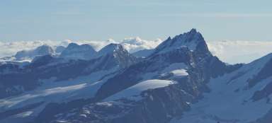
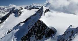
Front Rimpfischhorn – toothed comb

View from the top of Strahlhorn
View northeast of Lake Mattmark

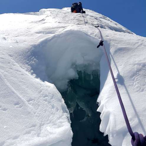
Overcoming cracks on the fir ridge
To the right of us in sight of the Matterhorn, from here we still have a good three hundred meters to the top of Strahlhorn.
Day "Third"
Ascent to Alphubel
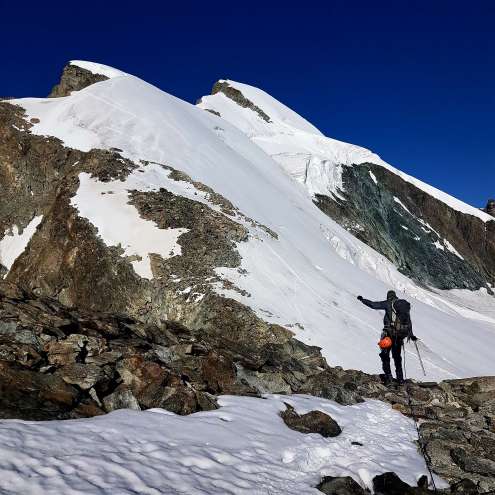
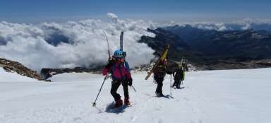
This ascent was not originally planned at all, or not from the Feejoch saddle, it began to seem like a viable option after we watched the route as we descended from Allalinhorn. In addition, we wanted to use the metro, which will take us to 3500 m. This time we pack all our things in the cottage and set off „until“ the sixth, the first metro leaves at half past seven from Felskin, so there is no need to hurry. From Saas-Fee, the first Saturday 4,000-meter hikers arrive by cable car, mostly groups led by guides to conquer the Allalinhorn. We try not to get too involved with them and we climb briskly up to 3800 m., To the saddle where the road divides; unlike the others, we set out on the way west – to Alphubel. We climb a rocky ridge along a snow bridge, speculate whether to tie up and put on cats, the path is not always obvious, the mountain is a little under our feet. Twenty meters below the peak of Feechopf (3888 m.) We give it up, the stones do not hold at all and we would have an unpleasant unsecured climbing ascent with helm –1, in addition to the uncertain possibility of abseiling back; the classic route from Alphubel leads elsewhere – via Mischalbeljoch, but due to time we needed to go back through Feejoch and back. So we will keep the conquest of Alphubel here for the next time, we have enjoyed the adventure enough.
Feejoch comb
In the background the Alphubeljoch Glacier

Feejoch
Boarding the ridge and the place just below the top of Feechopf (3888 m.), From which we decided to return.

Allalinhorn from the west
A final view of the Allalinhorn from Feejoch and groups of Saturday's 4,000 tourists on Saturday.

Articles nearby


Giga List: Alpine ascents to peaks higher than 3,500 m
The vast majority of peaks in the Alps higher than 3,500 m above sea level are already among the most difficult ones with the… continue reading
Article: Hikes and mountain ascents in the Valais Alps
The Valais Alps offer countless beautiful hikes and mountain ascents. The highest peak of the Valais Alps is Dufourspitze (4,634… continue reading