Ascent to Praděd, Sokol and Lyra
Circuit through the highest peak of Hrubý Jeseník


There are many paths to Praděd, the highest peak of Hrubý Jeseník. The easiest, but also the least interesting, is the way from the parking lot at Ovčárna. However, if you really want to enjoy the nature and landscape of Hrubý Jeseník, I recommend giving preference to any of the other options. One of them is the road along the White Opava. In addition to Praděd, the circuit described below will take us to several lesser-known peaks, it is approximately 34 km long and can be managed in 10 hours.
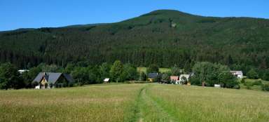
Karlova Studánka
The starting point of the route is Karlova Studánka, a small spa town or perhaps rather a village, located in a valley in the middle of deep forests. It offers an almost magical atmosphere. Much of the spa buildings are made of wood, and without some modern conveniences, one might feel like I was in another world, at a different time. Definitely worth a more detailed tour, which due to the small area of the town does not take much time. Bílá Opava flows through the town, springing high on the slopes of Praděd and which will accompany us along a large part of the ascent to its top. But first we will connect to an educational trail with the strange name Wide Web Museum, leading around an artificial water canal on the slope above Karlova Studánka. On the way we pass an artificial waterfall (there is not much to see from above) and a pleasant forest path leads to the road, where we turn left and after a few tens of meters we turn onto a trail along which leads blue and yellow hiking trail together with nature trail Bílá Opava.

White Opava Valley
We have before us one of the most beautiful places in the whole Hrubý Jeseník. Bílá Opava flows through a deep, relatively wild valley and creates a number of rapids and small waterfalls. The journey is comfortable at first, but soon becomes more challenging. At the Na paloučku crossroads, the roads split for a while to reconnect after about 1.5 km. While the blue leads higher up the slope and avoids more demanding places (but also the most attractive ones), the yellow still continues around the stream and is full of wooden footbridges and ladders, in some places there are chains. Just before reconnecting with the blue sign, the highest, 8-meter-high waterfall passes by.

Cottage Barborka
At the crossroads Nad vodopády Bílé Opavy, the blue and yellow signs will meet again for a while, but soon they will part again at the crossroads Pod Ovčárnou. Yellow leads to Ovčárna, from where you can continue to Praděd on the asphalt road, but a better choice is to take a shorter and more pleasant way along the blue to the tourist cottage Barborka.

Pod Pradědem
From the cottage, the blue sign continues along the asphalt road to the U Barborky crossroads, where we turn right and continue along the red road to the Praděd – crossroads crossroads. This part of the ascent is a bit dull, but at least it's running pretty fast. From the crossroads, only the last kilometer remains to the top of Praděd. Although still on the road, but above the forest line, so we can enjoy a great view of the surrounding hills.

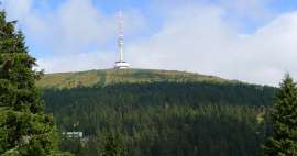
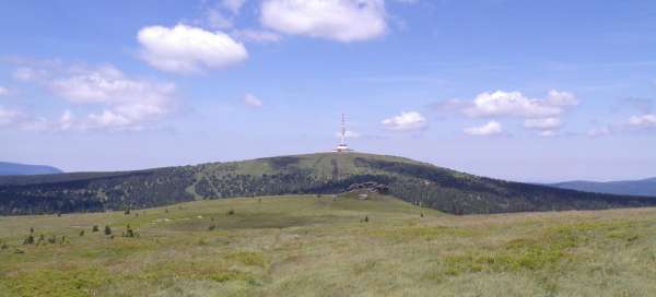
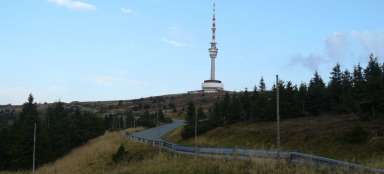
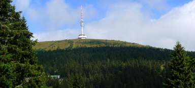
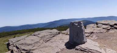
Great-grandfather
At the top of Praděd, at an altitude of 1,491 m above sea level, there is a huge transmitter. He is not as handsome as the one on Ještěd, but he cannot be denied a certain charm. The building also includes a restaurant and an observation deck at a height of 80 meters, accessible by elevator after paying the entrance fee. In case of nice weather, there is a wonderful view from above not only of the Jeseníky Mountains, but also of the Beskydy Mountains and sometimes also of the High Tatras, Mala Fatra or the Alps.

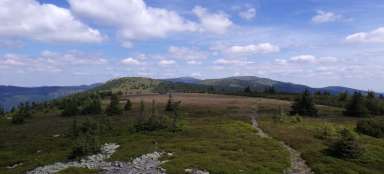
View of Vysoká hola
However, due to the outlook, it is not necessary to spend money on admission to the lookout tower. There is also an excellent view from the ground. For example, to the south towards Ovčárna, Petrovy kameny and Vysoká hola.

Swiss
Another destination is the cottage Swiss. From the top of Praděd, it is less than 4 kilometers of gradual descent. First back to the crossroads Praděd – rozc. and then turn right on the red road to the cottage. In front of the cottage there is a small bell tower with memorial plaques with the names of tragically deceased climbers from this region. In the local restaurant there is a last resort. For the rest of the route, you only need to rely on your own supplies or what you find in the forest.

Little grandfather
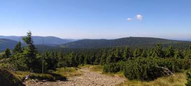
At the crossroads by the cottage, turn right onto the blue road and finally get rid of the asphalt. Modrá climbs over the ridge of Malý děd (1,368 m above sea level), but unfortunately does not lead directly over the peak, which is less than 200 meters from the trail and is inaccessible to ordinary tourists, as we are located in NPR Praděd, where movement is allowed only on marked trails . But also from the trail there is a nice view of the nearby and more distant hills.

Pod Sokolem
From Malý děda, the road descends to the Černík crossroads, where we turn right, still following the blue road. After about 350 meters there is an unmarked turn to the left leading to Kamzičí vrch (1,173 m above sea level). Thanks to the fact that we are already outside NPR Praděd, we can afford to leave the marked route and conquer another peak, which in itself is not very interesting, but a little further there are several rocks from which there is a nice view. Then we return to the blue marked trail, still descending. We will soon come across a wide forest path (fortunately it is not asphalted yet). Blue continues down, but we set out on this unmarked path, referred to in maps as the Silon Route. First a slight ascent and then almost along the contour line we reach below the saddle between Praděd and Sokol, where a footpath turns right from the Silonová route leading up to the saddle below Sokol.

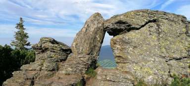
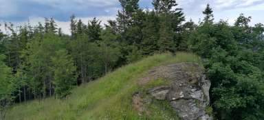
Falcon
In the saddle we turn left, the trees soon part and we reach the first rocks, from where there is a nice view. It would seem that we are already at the top of Sokol (1,187 m above sea level), but this is not the case. The peak itself is almost 300 meters away and apart from a small wooden cross is not noticeable. Another 100 meters further, a little lower on the slope, lies the most prominent dominant of the peak, Sokolí skála (in the photo below you can see only a small part of it protruding in the distance above the trees at the end of the ridge on the right).

View from Sokolí skály
Sokolí skála is a massive rock wall, about twenty meters high. But thanks to the fact that it is partially „sunk“ on the slope, it can be easily reached from above. There is above all an excellent view of Praděd from the rock, but there is an equally nice view of other peaks – eg Orlík, Medvědí vrch, Prostřední vrch and somewhere between them there is another today's destination, Lyra.

Timber road
We return to the saddle between Sokol and Praděd and turn left after an initially steep, later gently descending path around Sokolí chata, which will lead us to a comfortable Dřevařská cesta. Follow it to the right and bypass Prostřední vrch and Ostrý vrch. Occasionally there is a nice view of the surrounding forests among the trees. The road will take us to road 450 between Karlova Studánka and Vidly.

Lyre
If you have had enough, you can take the road to Karlova Studánka. If you don't have enough yet, you can beat another lesser-known thousand, Lyra. We cross the road and continue along a forest road, which branches off in two directions after a few tens of meters and thus bypasses the Lyra ridge on both sides. Around the place of this branch, it is necessary to find an inconspicuous path leading to the top. Lyra actually has two peaks, the southern one has a height of 1,086 m above sea level, higher and the official peak is still 6 meters higher. The summit itself is not very interesting, it does not offer any views and if it were not for geodetic signs, we would not really know exactly where it is. But a little further there are several rocks, from which there is quite a nice view.

Roland's stone
From Lyra, we descend along a footpath leading along the eastern slope, cross the Border Path and then join another unmarked path. After 1.5 km we reach the crossroads with the nature trail Museum Wide Web. There is also a short detour to the last stop – Roland's Stone. It is a relatively distinctive rock with a wooden cross on top. The view from above is partly limited by trees, but it is definitely worth a little effort with the ascent. And finally, there is only the final descent back to Karlova Studánka, either by a shorter variant along one of the unmarked paths or a longer variant along the Wide Web Museum nature trail.

Articles nearby


Giga List: The most beautiful hikes in Hrubý Jeseník
Hrubý Jeseník is the second highest mountain range in the Czech Republic and not only for this reason it promises very beautiful… continue reading