Ascent to Vysoká hola and Břidličná hora
Circuit through the second highest peak of Hrubý Jeseník


High sticks may be a less attractive target at first glance than the nearby and slightly higher Praděd, but in reality it can be more interesting in many ways. Even though the really highest point is the entry ban. As part of the circuit described below, we will also ascend to Břidličná hora and Pecný. The circuit is about 28 km long and takes about 8 hours to complete.
Ant
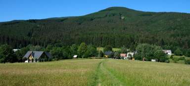
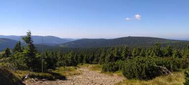
The tour begins and ends in Karlov pod Pradědem. Thanks to the local ski area, there are several parking lots, so it is not a problem to park your car for one of the whole day. Following the green marked hiking trail, we will first pass through a large part of Karlovy Vary and at the end of the village we will slowly begin to climb the forest road along the slopes of Klobouk to the Mravencovka crossroads. Among the trees, a view of the forest-free ridge between Břidličná hora and Vysoká holí sometimes opens up.

Pod Jelencem
At the Mravencovka crossroads, cross the cycle path and continue up the green, this time on the slopes of Jelenec. On the way we pass an unmarked turn to its top with an altitude of 1,038 m. However, one could probably discuss whether it is really a full-fledged peak or rather just a promontory of another hill, Jelenka.

Alfredka
We will soon come to another crossroads, named after the originally hunting, later tourist cottage Alfrédka. Unfortunately, the cottage burned down in 2002, so only the overgrown foundation remains after it. But maybe it will be restored once again, just like after the first fire in 1962. For now, there is at least a small snack bar with limited opening hours in the next cottage.

Under the Deer Well
From Alfrédka we set off along the parallel red and yellow, passing through the nature reserve Pod Jelení studánkou, which is mainly characterized by an unusually high number of anthills. The trail gradually rises around the top of Jelenka (1,214 m above sea level), often lined with blueberries, to the crossroads of Jelení studánka.

Deer well
The Jelení studánka crossroads is located above the forest border on the main ridge of Hrubý Jeseník, in a saddle between Břidličná hora and Jelení ridge. The crossroads is named after a nearby well with a relatively abundant spring. Next to it is a small stone hut which can serve as a shelter from bad weather.

Slate mountain
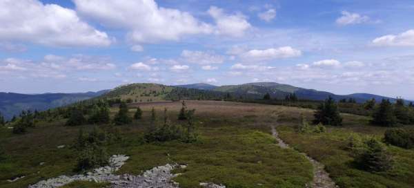
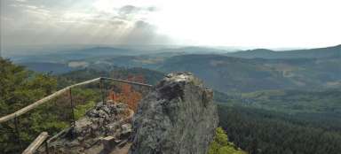
If we went straight to Vysoká hola, we would continue from the crossroads to the right along the red road. But once we've climbed this far, it would be a shame not to make a small detour (about 5 km) and conquer the other two peaks (especially when it's almost flat). Instead of turning right, we turn left along the green. After a few hundred meters, we will have a not very significant (at least from this place) peak of Břidličná hora (1,358 m above sea level) on the right side. There is no marked path leading to the top, but several well-trodden paths lead to it. It has a great view and a little rocky sea just below it.

Furnace
The second peak is slightly lower Pecný (1,330 m above sea level), about 1.5 km further along the green from Břidličná hora. The top is a small rock and again offers beautiful views in all directions. Zelená continues to Lost Stones and further south, but our main goal lies in the opposite direction, so we return to the Jelení studánka crossroads in the same way.

Above the Little Cauldron
From Jelení studánka we continue along the slopes of Jelení ridge and in less than half an hour we reach the crossroads Nad Malým kotlem. The green turns left here, down from the ridge. So we now continue along the red road to Vysoká hola. The comfortable path only climbs slightly and in less than an hour we are at Vysoká hole.

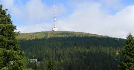
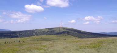
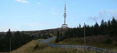
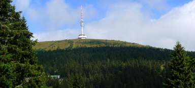
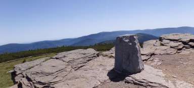
High sticks
Vysoká hole (1,464 m above sea level) is the highest point of this circuit and the second highest mountain in Hrubý Jeseník. However, the peak is formed by a large platform and it is not easy to determine the really highest point. The signpost is located on a wooden hut (probably a conservation station), but the highest point will most likely be elsewhere. In the maps, it is marked about 400 meters northwest of the signpost (due to the fact that we are in NPR Praděd and there is no marked trail leading to it, it is therefore inaccessible). In some maps, there is even a point marked one meter higher next to the red marked trail, less than 200 meters in front of the signpost, but it is probably not marked in the terrain. In front of the wooden hut there is another interesting thing – a boundary stone from 1681, on which the coats of arms are still clearly visible.

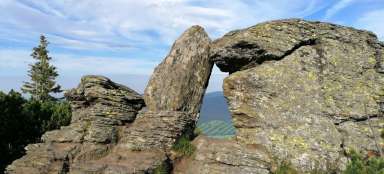
Peter's stones
Now we have practically only a continuous descent (except for one short section) to Karlov pod Pradědem. The path leads past the legendary Peter stones, but at a respectful distance. Directly to Petrovy kameny are again forbidden, although on the other side there is a ski lift, which ends just a few meters below them. So if you want to see them up close, go skiing here in the winter.

Above Ovčárna
The road will take us to the crossroads Nad Ovčárnou, where we turn right along the blue marked route (or you can turn left and treat yourself to refreshments at Ovčárna – the walk is about 1.5 km). At the next crossroads Nad Velkém kotlem you can choose whether to continue on the blue or yellow, both routes lead to Charles. Perhaps a little more advantageous is to choose blue, which is a little shorter, offers several views of the Great Cauldron and at the bottom leads through the valley around the river Moravice. But the yellow route leading along the ridge around the Temná and Kopřivná peaks certainly has something to offer.

Articles nearby


Giga List: The most beautiful hikes in Hrubý Jeseník
Hrubý Jeseník is the second highest mountain range in the Czech Republic and not only for this reason it promises very beautiful… continue reading