Article Trek through Hardangervidda
140km trek through the Hardangervidda plateau


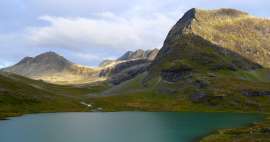
Hardangervidda in the middle of southern Norway is a huge plateau covering an area of about 8,000 km2, which is about 1/10 of the area of the Czech Republic. However, the surface of the platform is not as completely flat as it might seem. It could be characterized as slightly undulating with many more pronounced peaks and valleys.
Across the mountains and mines behind the Norwegian Trolls
15 days of wandering through the rugged but incredibly beautiful Norwegian nature
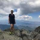
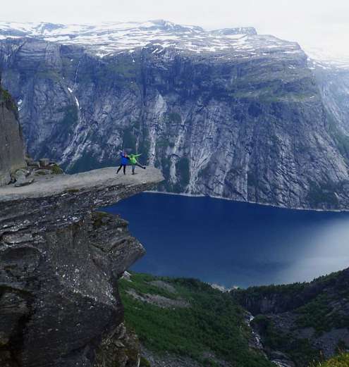
From June 29 to July 13, 2017, we undertook an approximately 140-kilometer-long crossing of the Norwegian Hardangervidda plateau. There were four of me (59) my wife Hanka (52) and our acquaintances Karel (51) and Dáša (46). For all three named it was the first Norway, for Karel and Dasha even the first trek in life. Hanka and I consider ourselves quite seasoned travelers, but two newcomers took care of some interesting and unusual situations for us at any moment. The planned trip began in Tyssedall and the local part of Skjeggedal known as the starting point for the trip to Trolltung. Around Trollunga further northeast to the highest hill in Vidda, Hårteign below the Harangerjökulen glacier. We bypassed it from the northeast side and the destination of our trip was Finse 1222, Norway's highest railway station. (The number in the name is its altitude) The trek itself is one of the moderately difficult, but due to the slightly delayed spring in Norway, it became a trek of the highest difficulty thanks to the snow that awaited us at altitudes above 1,200 m. In addition, our two newcomers had slightly worse equipment and so they got pretty busy. But the fact is that they went all the time without whining and complaining, even though sometimes they probably weren't very happy. A short excerpt from Dáša's diary was added here: „The rain was getting stronger,“ so we hurried to set up the tent! put the sail in the opposite direction before we had the entrance !! Ajéééje! well again !! My fingers froze despite my gloves, I could squeeze them. Well, the glory managed to fasten the tent stones and climb into the tent and put dry things. We had a little water with you ,, that was enough for soup ,, so we cooked it in the hall ,, we had dried meat ,, we crawled into the sleeping bag up to my ears ,, I put on my second warm gloves to sleep. It rained all night and was We had a badly turned tent, the wind was blowing so badly on the wider area, that the tent was completely lying on me !! We are on a plateau and there is a nice scythe !! I couldn't even sleep, the wind was blowing and I she was holding the poles from the tent ,, so that they wouldn't fake !! It is said that it will last and I should not be afraid ,, said Karel ,, so I listened to him ,, she went into the sleeping bag and knocked ,, to make the tent stand. " Endless crossings of snow plains and many snow-ice bridges over wild rivers provided us with a constant and unceasing influx of adrenaline. As a cherry in this adrenaline cake, we had about 35–40m wide and quite deep (the ladies had it up their buttocks) the ford of the river, whose banks were more or less under the snow and the water temperature corresponded to that. The snow was also responsible for a partial failure, namely the non-conquest of the Hårtiegen mountain by 1690 m. Further river crossings on rope-swing bridges were just an innocent pastime. We pedaled for about 13 km a day and in places where the snow was not a little more. All the time we had absolutely amazing weather, ie Norwegian conditions. It looks something like this: one day the sun, the sky without a single cloud temperature around 22 ° C, the next day a strong wind estimated in gusts so 60km / hk in the evening rain is added with ice floe the temperature is just below zero. The next day overcast, the clouds move on the ground, in the afternoon the sun peeks out but the next day it rains. Somehow it changes differently the whole time we are on the trek. Normal for Nora, a bit of a surprise for us from the beginning, but thanks to a good plum brandy it was manageable. Also, the fact that the sunrise is about 4 in the morning at this time of year and the sunset after 11 pm is quite curious for some of us. Moreover, the night, which could be expected between sunrise and sunset, somehow still not and does not come, is just a kind of strange twilight, night – night. edge of the Hardangerjökulen glacier. Finally, some more practical information: we bought a Prague – Bergen return ticket well in advance about 7 months and therefore cost only 3,900 / person, including checked baggage 20kg, we spent about the same amount on trains and buses in Norway. So the sum of the trip for 15 days for about 8,000 Everywhere you can pay by card, everyone speaks English, buses and trains run accurately, they are clean, the staff without exception smiling and helpful. We consumed dried meals of our own production all the time. The weight of the food was 7 kg / person, including 0.75 l of plum brandy. The weight of the backpacks is slightly over 20 kg at the start. We only bought cooking gas on the spot.
Day 1
The worst climb is behind us and we come across the first snow

Day 2
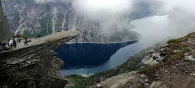
Evening Trolltunga
Day 3
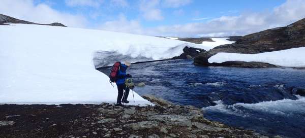
Above 1,200m we have endless snow plains .......

Day 4
...... and snow-ice bridges over wild streams

Day 5
Hanka has already done the worst, I transferred the first deeper part of the ford to her island, because otherwise she would have wet it. The second wider part was already shallower. Water temperature just above zero.

Day 6
How we did not conquer Hårtaigen … snowy and glaciated chimney, impassable without cats, did not allow us to climb to the highest point Hardangervidy-Hårtaigen 1690m

Day 6 continues
We descend from Hårtaign about 500 m high and green plains open in front of us

Day 7
White has been replaced by green, and the swing bridges are full of buzzing after the snow.

Still 7th day
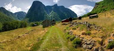
… we follow the beautiful river and in the distance you can see the tourist cottage DNT Hedlo

Day 8
We continue along the river Veig

Day 8 continues
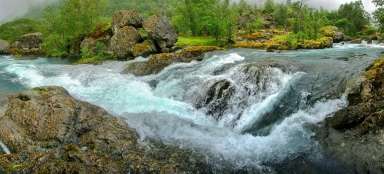
..... and the whole Veig River eventually fits into this bottleneck. Valurfossen waterfall.

Day 9
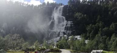
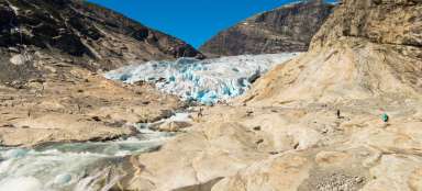
After nine days, we came to civilization at another Voringfossen waterfall.

Day 9 lasts
… and we take advantage of the „gains“ of civivization

... and 9 more.
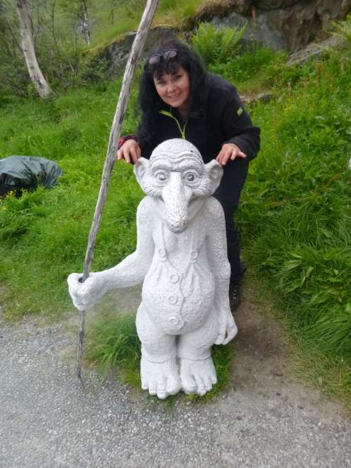
Tahati trolls behind the ears, summoning an ugly weather change.
Day 10
..... and it's here, I said don't pull him by the ears

And 10. continues
It seems that the troll has already forgiven us and we can enjoy an altitude difference of 1,300m. Exactly that much from the photography site down to Simadalsfjorden.

Day 11
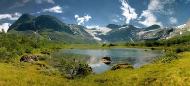
Finally, the Hardangerjökulen glacier and the Rembesdalvatnet lake below it appeared.

Next from the 11th day
Lost in endless stone slabs.

The 12th
And the snow again …

The 12th
The dips in the snow show us how much there is actually below us.

Day 13
To Finse, our destination is only a short distance away. The river flows into Lake Finsevatnet.

The 14th
Only Hanes and I go easily to the Hardangerjökulen glacier.

End of the 14th day
We're all in Finse 1222 and it's the end of the expedition, it was hard, but it was wonderful. Tomorrow morning at 4:07 we take the express train to Bergen and then we fly home.

Articles nearby


Giga List: The most beautiful treks in the world
In this overview, selected treks that have a duration of at least a week are selected. All of them have breathtaking views,… continue reading
Giga List: The most beautiful tours in Norway
Norway is a very mountainous country and offers incredible opportunities for tourists. Due to the harsh weather, the local tours… continue reading