Cycling to Großer Arber / Big Maple
The highest peak of Šumava

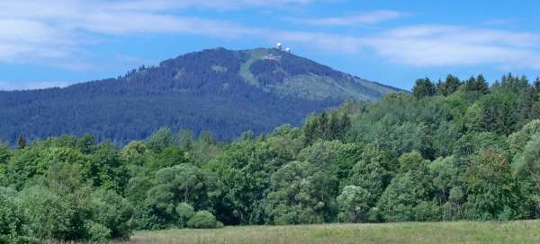


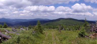
In addition to being the highest peak of the Šumava with its altitude of 1,456 m, the Großer Arber or Velký Javor is also one of the most easily recognizable Šumava peaks thanks to its unmistakable silhouette with a pair of radars visible from afar. Its surroundings are interwoven with a dense network of marked and unmarked paths and thus offers an inexhaustible number of options for how to get to the top. One of them, this time for cyclists, is described in this article.
Target in sight
The route leads mainly along paved forest roads, some sections are on rocky footpaths and part of the route leads along roads. It is thus suitable for trekking or maybe better mountain bikes. In many places, however, it is possible to choose between several alternatives and more technically demanding sections can be avoided (at the cost of a slight extension of the route). In the basic variant, it is about 50 km long with an elevation gain of about 1,500 m. The route begins (and also ends) in Železná Ruda. First we set off on the cycle path 2072 to Alžbětín and then to the border crossing Železná Ruda / Bayerisch Eisenstein. From here, the first ascent awaits us. After the border crossing, we turn right and climb up the main road (part of which can be bypassed by side streets). At the end of the town, in a place called Neuhütte, we turn left onto the forest path Gläserner Steig, marked in black on the map. This is a comfortable slightly ascending path. In some places there is a view of Velký Javor. We will soon reach the cottage Burglengenfelder-Hütte from where it is only 1 km slightly steeper ascent to the village of Brennes at an altitude of about 1,030 m. Alternatively, it is possible to go the whole route from Železná Ruda to Brennes by road.

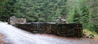
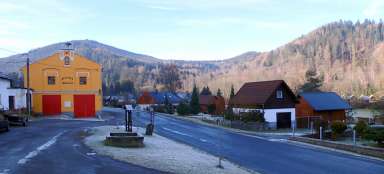
Brennes
From Brennes it is possible to continue along the red Wanderweg 9 leading directly to the top of Velký Javor. However, we will still stick to the black Gläserner Steig. In Brennes we pass a ski school with a stylish fence and slowly descend to the mountain hotel Mooshütte and further to the Kleiner Arbersee.

Kleiner Arbersee
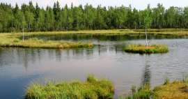
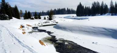
In a few minutes we are at Kleiner Arbersee. The Czech name Malé Javorské jezero may be a bit misleading, the Malé Javor Lake might be more accurate. The photo below also deceives, showing only a small part of the lake with a restaurant on the opposite shore. In fact, the lake is relatively large (6.36 ha), only slightly smaller than the Großer Arbersee (Great Maple Lake, but more properly perhaps the Great Maple Lake). But it is definitely more romantic than the Großer Arbersee. It is surrounded by forests all around, there are several floating islands on the surface and the peaks of Malý and Velký Javor can be seen above the lake. An educational trail leads around the lake.

The most demanding section
The restaurant by the lake invites you to visit, but I recommend you have something light as much as possible, as we have the most demanding section of the entire circuit ahead of us – climbing to the saddle between Malý and Velký Javor, which is almost 400 meters higher. We will leave Gläserner Steig and continue along Fernwanderweg E6. The first two kilometers lead along a comfortable paved road. The joy of driving spoils the road a bit only in some places. After 2 km we arrive at a crossroads. The marked path turns left. The paved road continues straight on without any markings. If you follow it, it will take you around the Malý Javor around the saddle (or in this case it is not necessary to drive directly into the saddle, but it is possible to continue straight on to Velký Javor). However, a more interesting option is to turn left and continue along the marked route. This variant is shorter and you will enjoy a beautiful view of the countryside. A certain disadvantage of this route is that the comfortable path becomes a stony, upwardly impassable footpath (rather impassable in the wet) and so a large part of cyclists will probably walk here and the more trained will go here at a slow walking speed (and sweat much more than when walking). But it is only one kilometer and up in the saddle there is another cottage with a restaurant where you can recharge your batteries – Chamer Hütte.

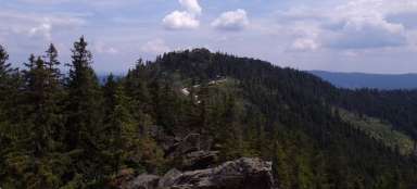
View of the Kleiner Arbersee
From the cottage you can jump to the top of the Kleiner Arber, which rises to a height of 1,384 m above sea level (better probably on foot than by bike). After returning to the chalet, there are several options to continue to the top of the Großer Arber. The shortest option is to continue along the Fernwanderweg E6 (parallel yellow and green), which is more for hikers. Another alternative (longer, but more comfortable – paved and then gravel road) is to continue along the green Wanderweg 3, then after the unmarked junction (Auerhahnstraße) connect to Wanderweg 3a, which after a while leaves us by turning left. We will still stay on the broad road until we rejoin the Fernwanderweg E6. Before the Bodenmaiser Mulde crossroads, we turn sharply to the left and the final ascent awaits us. Just before the top itself, there is a short turn to the lookout, from where there is an amazing view of the Kleiner Arbersee, among others.

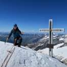
Top
It is only a few meters from the viewpoint to the top. However, it is necessary to leave the bike on the edge of the top platform, it is not allowed to continue with it. There are several rocks on the top plateau, the cross is located on the highest of them. The panorama is somewhat disturbed by two huge domes of military radars, but over the years it has somehow belonged to the Great Maple.

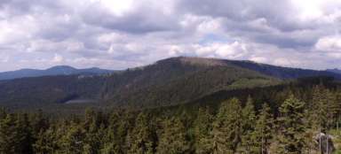
Large seed gel
The largest of the rocks that can be climbed and from which the previous photo is taken is the Großer Seeriegel. At its foot is a small wooden chapel and from above there is a beautiful view of the Bavarian Forest.

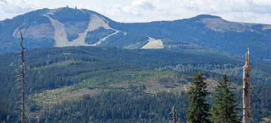
Bodenmaiser Riegel
This photo is also taken from the Großer Seeriegel with a view of another rock on the top plateau – Bodenmaiser Riegel. You can climb it too.

Downhill
Another destination is the Großer Arbersee, which is about 500 meters below. Again, there are several ways to get to the lake. For cyclists, it is probably best to go back around Bodenmaiser Mulde, then turn left and follow the Auerhahnstraße to Wanderweg 3a and then take one of the paths (either marked or unmarked) to the Arberseestraße road, which leads us to the lake.

Großer Arbersee
On the edge of the lake is a parking lot with a restaurant. Passing cars quite disturb the atmosphere of the place. However, there is also an educational trail around the Großer Arbersee, on which one can still enjoy the atmosphere a little more.

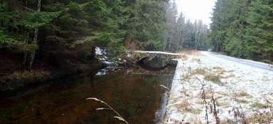
Return to Železná Ruda
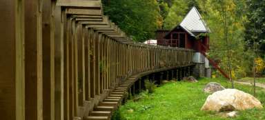
There are many paths back to Železná Ruda, so it only depends on you which one you choose. One option is to take the road to the village of Regenhütte, where we connect to the REG, EV13 cycle path, which takes us to the other side of the river Großer Regen, cross the road and the railway viaduct, and enter the Bavarian Forest National Park. Following a pleasant forest path leading around the Große Deffernik river, we will reach the tourist border crossing Debrník / Ferdinandstahl (photo below). From here, we will continue along the Sklářská / Secret Defense of the Iron Curtain nature trail, which will take us around several military facilities to Železná Ruda. ** Note: ** Most of the route in Germany leads along cycle paths that are marked in the terrain (and in printed cycling maps). Unfortunately, they are not marked on the tourist map of the mapy.cz server, so for better orientation in the description, I kept the names of tourist routes as they are listed on mapy.cz.

Articles nearby


Giga List: The most beautiful hikes in Šumava
Šumava offers the most peaks of the Czech mountains over a thousand meters above sea level, although most of them are not very… continue reading