Ascent to Mount Sajama 6,542 m above sea level
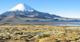
The highest mountain in Bolivia


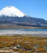
Mount Sajama is the highest mountain in Bolivia and is located in the Sajama National Park south of La Paz. The national park lies on the border with Chile. The ascent to the mountain leads from the base camp (4800 m above sea level) through the high camp (5700 m above sea level) to the top and back to the base camp.
Road to Sajama National Park
Transport to the Sajama National Park itself is not the easiest in itself, so if you want to use local public transport and not arrange your own transport. The minibus to Sajama National Park leaves every day between 12–13 hours (depending on when it is filled) from the village of Patacamaya, which is about 1–2 hours (depending on traffic and traffic) away from La Paz. Do not expect any official stop in the village, the bus stops on the main street opposite the hotel (we found this label on the Internet and found a place according to it). Seats in the minibus are limited to about 15 people, there were 17 of us in the end, and only thanks to Belgian tourists who helped us find our 2 seats on the bus in Spanish (at the expense of a villager with a bag of something who drove the next day).

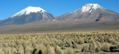
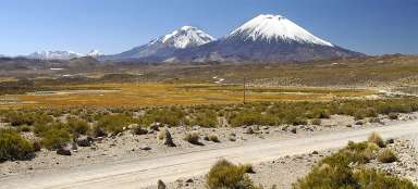
Views along the way
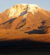
The journey itself lasted about 4 hours, which was no comfort under the tight conditions of the minibus. Still, the views along the way were worth it. Grazing llamas and alpacas on slopes and pastures, often a desolate landscape with only occasional solitary buildings and with increasing distance traveled, the mighty peak of the Sajama itself appeared on the horizon.

Sajama village and ascent to Base camp
After 4 hours of bumping in the minibus, we finally reached the village of Sajama (4239 m above sea level), where we also registered and paid the entrance fee to the Sajama National Park (approximately 100–150 Bolivians). Then we agreed to have a local guide take us to the end of the dirt road (4322 m above sea level), from where only a rocky path to Base Camp (4800 m above sea level) continued.

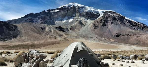
Base camp 4800 m above sea level
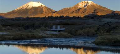
The trip to Base Camp took us about 2.5 hours, just until sunset, when we managed to set up a tent. The temperature difference between day and night is significant at this altitude. We could have been around 8 ° C on the climb, but immediately after sunset the temperature dropped around 0 ° C to minus degrees. The Base camp itself is a flat platform covered with fine dust, which covered everything we could (after a few openings and closing of the tent, the zippers stopped working – it was helped by a thorough washing with water at home). You will also find a spring with water for cooking or, after disinfection, for drinking. The camp is located at the very foot of Mount Sajama, so the views are worth the hard work to get here.

Climb to the top
I personally ended up in Base Camp, due to intestinal problems that I encountered several times during our trip to Peru and Bolivia. So a friend went to the top alone and because I was waiting in our tent at Base Camp, he had to climb to the top in one day. So from Base camp (4800 m above sea level), through High camp (5700 m above sea level) to the top (6542 m above sea level) and down to Base camp. I will describe the output itself at least indirectly. By default, the ascent goes for 3 days – 1st day base camp, 2nd day high camp, 3rd day in the morning you go to the top and then straight down to the base camp.

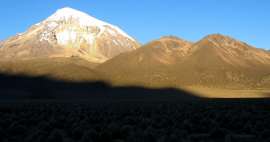
Sunrise
The ascent began to rise from the base camp as early as about 5 o'clock in the morning to catch up all the way, and also because it is more advantageous for the ascent along the snowy part when the snow or ice is still frozen at night. When the sun comes up, around noon the snow starts to soften and it rises worse on a steep slope.

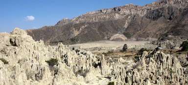
Penitents
On the way under the peak, you pass a belt of so-called penitents (Penitentes), which are spikes made of ice, which are so strong that even a cat can hardly be kicked. This natural phenomenon occurs in glacial areas and is caused by the sun's rays, which have penetrated deeper in some parts of the ice than in other places. The path along them is steep, whether it is the frozen on the way up or the melting on the descent. The obligatory equipment for this ascent is undoubtedly cats and ice ax, which are necessary on the parts of the road that is covered with ice.

Orientation on the road
The road to the top changes during the season and thanks to the weather conditions, both the sections that are covered with snow and the part of the road leading along the glass massif. If you are doing the business yourself without a guide, it is necessary to prepare and thoroughly study the route. GPS navigation is suitable, for example, a route recorded in a smart watch, as a friend had to ascend. On the contrary, relying only on a mobile phone does not have to pay off, because due to very low temperatures, most technology does not last batteries and you still cannot take off your gloves for a long time, because then there is a risk of frostbite.

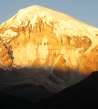
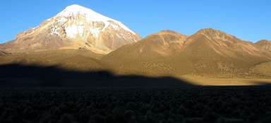
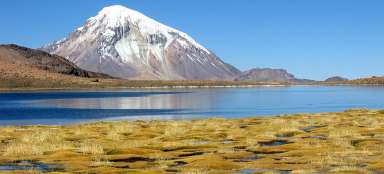
Sajama peak
The peak itself is formed by about 50m of flat glacier area without a top cross or other markings. From the top, but also when climbing to the top, there are amazing views of the surrounding volcanoes that line the Bolivian-Chilean border. There are also two 6,000 among them, which are a popular destination for climbers. At the very top, there is not much time or appetite for long rests and loving the landscape. The conditions here are very hard, strong icy winds and temperatures well below zero, even at noon in the sun, do not allow it to linger too long. The climber then waits all the way back to the base camp. A friend managed the trip Base camp – peak – Bace camp in about 10 – 11 hours, but it is very physically demanding. Even the ascent with a stop at the High Camp is suitable for the more athletic and, above all, well acclimatized to the local height. The ascent itself is described as not too technically demanding, yet the knowledge of using cats with ice axes, high altitude and mastering the movement in the field requires considerable experience and physical preparation.

Articles nearby


Article: Trip to the NP Sajama
Classic trip to Sajama National Park as a Lagunas de Altura trek introduces you to all the beautiful places here. You will have… continue reading
Giga List: The most beautiful tours in the NP Sajama and Lauca
In the border area between Chile and Bolivia, you will find two neighboring national parks, Lauca and Sajama. Both offer… continue reading