Ascent to the Gross Grünhorn
Ridge climbing in the Bernese Alps

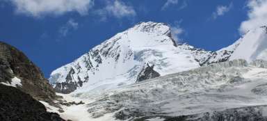
The Gross Grünhorn (4043 m) southwest ridge is a nice exposed climb of difficulty 3 places, preceded by a classic glacier hike with an overnight stay at the Konkordia hütte. The final climb leads over the summit of the Grünegghorn (3860 m). Overall difficulty is listed as PD+. We went there in July 2023.
Aletsch Glacier
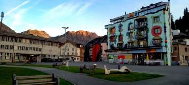
It starts in the village of Fiesch, from where the cable car goes to the Fiescheralp (2200 m). From the top of the cable car, you follow a path where bikers and tourists pass you, you pass through a tunnel about 1,200 meters long and after another 1.5 km you are at the glacier. The Alletschgletcher is the largest valley glacier in the Alps. However, it has lost over a third of its area in the last thirty years. The sight of it is really pitiful, it is a torn plain, where two rubble tracks rise in the middle, as if a highway passes through it. We walked part of the scree because it avoided the bigger cracks, but we didn't figure it out until about halfway through the route and then applied it on the way back. You walk through the glacier like a lunar landscape, you walk along it for several kilometers and it will take you at least two and a half hours, but more, because you get tangled up in crevasses. The deep furrows are green-blue in some places, black and full of debris in others, in some the water rushes like a stream. Crossing the Aletschgletcher is a great experience and experience, but at the same time you are a little sad about how the glacier looks and realize that there will be nothing left for the next generation.

Konkordia hut
We left the village of Fiesch at noon and were only at the cottage for dinner, a little after six in the evening.
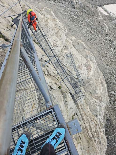
By ladder or via ferrata
The hut is approached from the south by via ferrata, that is, first you have to reach the edge of the glacier with crevasses, cross over scree and swaying boulders, and then scramble 200 meters high in places on markers. From the other side – from Konkordiaplatz – which is a kind of glacial square, or rather a glacial intersection directly below the hut – a hundred meter long metal stairs lead to the hut. Conquering both is an experience. The location of the cottage compared to the surrounding terrain is certainly an impact of the melting of the glacier. You don't want to be scratching up and down more than twice in two days. In addition, orientation around the cottage is quite poor, we managed to get lost twice.
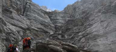
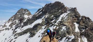
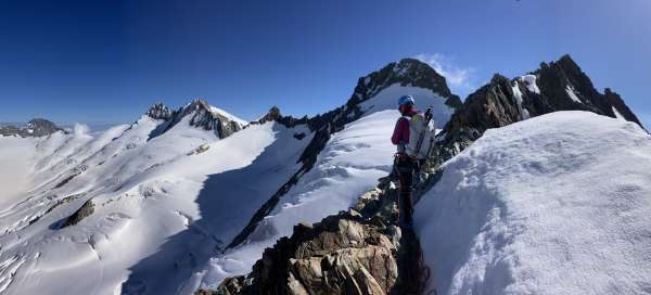
We climb to the summit ridge
We left the hut at four in the morning and managed to get lost right in front of the hut, because we were unable to find the metal stairs down by the light of our headlamps. The previous day we had come the other way down the via ferrata. Fortunately, the other couple was also leaving, so we didn't hang around for long. The trip up the glacier went well because we could walk on the stone debris and not have to deal with crevasses. The Swiss couple showed us correctly where to start climbing up between the rocks on the snow. When climbing the Gross Grünhorn, you combine all your alpine skills – not only walking on the glacier and scrambling over rocks and debris, but also climbing with a firm ice ax – there is one unpleasant section about 50 meters long, which is about 50 degrees and it depends on how good they are steps trampled in it. As far as the crest, which is barely peeking out from behind the snowbank in the photo, it is a fairly simple hike that will take you mainly physically.

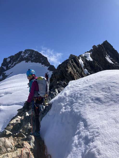
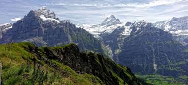
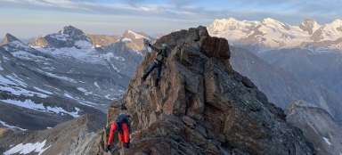
Grünegghorn
When you cross the snow bank, the ridge of the Grünegghorn appears in front of you. In the shot, I am standing exactly in the place where it is found. The top of the Gros Grünhorn is the second ridge on the left, you can only get to it by climbing the entire ridge of the Grünegghorn to the top – on the right. From there, you descend briefly down the rock – about 60 meters high, which is not a very pleasant climb down, because there is a lot of exposure.
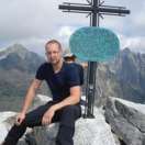
Gross Grünhorn
The final descent – after you've descended the Grünegghorn rock – begins with a firn passage. We have a bag hanging somewhere up there right at the start of the rock. It was where we pivoted, although the original intention was completely different. We originally planned it as a transition, i.e. over the Klein Grünhorn and then over the glacier to the Mönchsjoch hütte. This idea turned out to be misguided. I'm a little ashamed to say that it was also an acclimatization hike for us. You always think that you already have some experience, and then you do something stupid like this. Somehow we missed the information that the climbing difficulty between the two Grünhorns is AD+, which could still be managed if there was nothing else waiting for a person. On the Mönchsjoch hut
but it is further from here than back to Konkordia, and the journey along the glacier in the summer is not worth anything and, moreover, it is not well trodden.
Fortunately, some of that experience paid off and it also paid off that we met both two Swiss at that very moment and the mountain guide with the client who were going down from the top. They confirmed to us that the ridge ahead is difficult to navigate and that the storm, which was reported for six in the evening, is expected to arrive at three. We didn't wait for anything at that point and turned it around with them back to Konkordia. Of course, the storm didn't happen, but that's usually the case if you respect it, unfortunately I also experienced the second case and I never want to repeat it. We were exhausted anyway, I literally crawled like a snail for the last hundreds of meters with a persistent headache, which not even a pink pill helped.
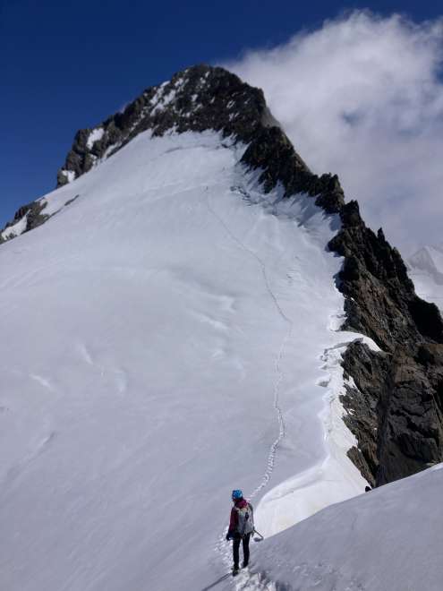
Descent down
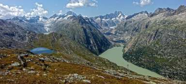
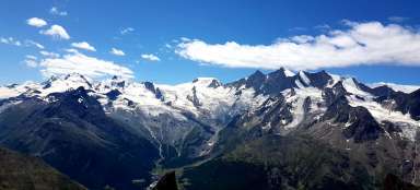
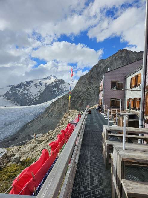
Somehow we missed the information that between the two Grünhorns the climbing difficulty is AD+, which could possibly be managed if there was nothing else waiting for a person that day. However, it is significantly further from here to the Mönchsjoch hütte than back to Konkordia, and the journey along the glacier in the summer is not worth anything, which unfortunately we did not know and could not read anywhere. Fortunately, one already has some of that experience, so when at that very moment we met not only the two Swiss who were coming down from the peak, but also the mountain guide. We understood quickly from what they said that the ridge ahead is difficult to navigate and, moreover, that the storm that was reported for six in the evening is supposed to come at three. So we turned it around with them back to Konkordia and they were quite happy for the company. Of course, the storm didn't happen, but that's usually the case if you respect it. We were exhausted enough anyway. I literally crawled the last hundreds of meters, with a nagging headache. The shot shows the view from the crest towards Konkordiaplatz.