Ascent to Faulhorn (2681 m asl)
Part of the Faulhornweg hiking trail in the Bernese Alps


A classic classic, alpine hike with views of the Wetterhorn, Schreckhorn, Eiger, Mönch and Jungfrau peaks and the Thunersee and Brienzersee lakes. Starting point – Grindelwald (1047 m above sea level). Elevation approx. 1634 m. Support points: cottage Berggasthaus Waldspitz (1903 m above sea level), cottage Bergrestaurant First (2166 m above sea level), cottage Berghotel Faulhorn (2669 m above sea level)
Grindelwald, north face of the Eiger ...
In the morning a quick transfer from the campsite in Lauterbrunnen to Grindelwald (parking Parkhaus Eiger, Endweg 1B). Grindelwald is a beautiful mountain resort, one of the oldest in Switzerland, which has not lost any of its charm for decades – the alpine huts are still decorated with flowering geraniums and above them are beautiful green pastures. All this is surrounded by mountains. As if carved by the northern wall of the Eiger, 3970 meters high, the shimmering slides of the Oberer and Unterer Grindelwaldgletcher glaciers and the crown-like shield of the Wetterhorn (3692 m above sea level).

Brunniweid Viewpoint (1247 m asl)
From Grindelwald to the Brunniweid viewpoint. View of the Grindelwald scenery, on the left a piece of the Mättenberg wall (3104 m above sea level), in the middle in the valley the Ochs pyramid (3900 m above sea level), the Gross Fiescherhorn (4048 m above sea level) and the Unterer Grindelwaldgletcher glacier, on the right the Eiger (3970 m above sea level).

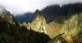
Waldspitz (1900 m asl)
Semi-wild goats

Milibachfall (1990 m)
Waterfall on the Milibach stream.

Under the top of First
„Cheese“ farm under the top of First.

First (2167 m asl)
An elevated footbridge leads to the top of First. The cable car from Grindelwald also ends here, so you will meet people here much more than on the way.

First (2167 m asl)
View of Wellhorn (3191 m) and Wetterhorn (3692 m).

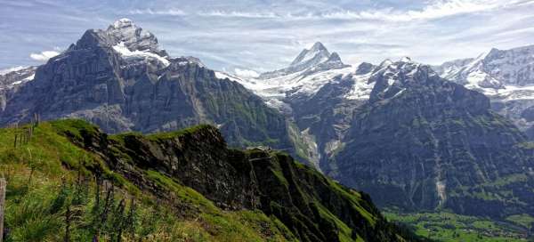
First (2167 m asl)
View from First. From left Wellhorn (3191 m asl) – Wetterhorn (3692 m asl) – Lauteraarhorn (4042 m asl), Schreckhorn (4078 m asl) and Kleine Schreckhorn (3494 m asl) – Mättenberg (3104 m asl) – Ochs pyramid (3900 m asl) nm) – Gross Fiescherhorn (4048 m asl) – Eiger (3970 m asl) on the right and Jungfrau (4158 m asl) and Silberhorn (3695 m asl) in the background on the far right.

First (2167 m asl)
First, in the background Wetterhorn, Lauteraarhorn, Schreckhorn and Mättenberg.

Road to Bachsee (2261 m asl)
The journey continues to the Bachsee ball.

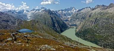
Bachsee (2263 m asl)
Alpine lake Bachsee.

Climb to Faulhorn (2352 m asl)
View down to Bachsee.

Faulhorn (2681 m asl)
Mountain hut on the top of Faulhorn. Tea and soup stung.

Faulhorn (2681 m asl)
Views of Lake Sägistalsee and Lake Brienzersee. It's getting a little tugged.

Faulhorn (2681 m asl)
Mountain hut just below the top of Faulhorn.

Descent to Grindelwald (1867 m asl)
Descent to Grindelwald by western road.

Grindelwald (1047 m asl)
Grindelwald from above.

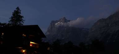
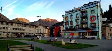
Grindelwald (1047 m asl)
Sunset over Grindelwald.

Articles nearby


Giga List: The most beautiful tours in Europe
Although Europe cannot boast such high mountains as other continents, you will still find beautiful hiking trails and ascents. In… continue reading
Giga List: The most beautiful tours in Switzerland
Mountainous Switzerland is an absolute paradise for mountain hikers. Almost every corner of the country offers breathtaking hikes… continue reading