Ascent to Lake Ala kol
The most famous place near Karakol


Variants of treks in Těr Alatau in the area near the town of Karakol are endless. Practically, but each of them leads around the most beautiful lake in the Ala cola area. The shortest way to it is from the Karakol valley from a camp called base camp. The road is quite tiring because you practically still climb a steep slope. At the lake you can camp and continue to the next valley, or you can have it as a day trip easily and return in the afternoon.
Base camp Karakol
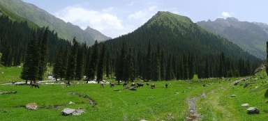
The trip to Lake Ala kol begins at the Base camp Karakol (2,550 m above sea level) idyllically situated on a wide meadow. It is always very lively here, as there are several hiking trails.

Bridge over a wild river
From the base camp, do not follow the „road“ as an unpleasant ford would be waiting for you after 300 meters, but along a footpath that turns into the valley to the west. Here you will find a small bridge over which you can easily cross a wild river.

Road ford
Follow the footpath along the river to get back to the road. Here you will sometimes meet unhappy tourists who have thought about how to go through this, because sometimes the off-road vehicle has a problem with it. So if you send them to the bridge (which is not visible from here) they will definitely be grateful :-)

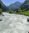
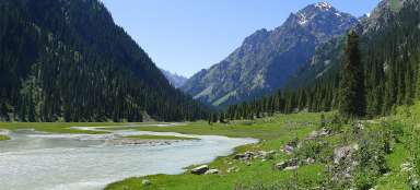
Karakol river
100 meters below is the bridge over the roaring glacial river Karakol. This is where the journey across the plain ends and the „endless“ ascent begins.

Canine
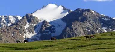
After crossing the bridge over the river Karakol, the road disappears in such a wandering forest, which was once filled with massive boulders from a mountain landslide. The road twists here and there and then begins to climb a fairly steep slope. After half an hour, a view of the other side of the valley finally opens, through the crowns of the local Schrenkiana spruces (Picea schrenkiana). Here is dominated by a pointed mountain with a height of about 4,200 meters above sea level.

Opposite valley
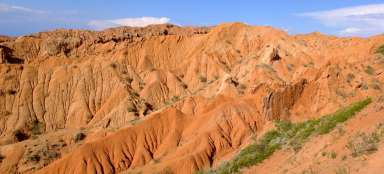
After the trail leaves the forest, the views of the opposite valley improve significantly. The surrounding vegetation is so „weed“ and the ascent through the curves in the sunny slope is not very pleasant. Compared to other places in Kyrgyzstan, you will meet a relatively large number of tourists – maybe more than 20.

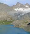
Buried valley
After you climb the „weed“ slope, the view to our valley opens up. Unfortunately, you will find that the strangely cleared area from the glacier, which from below looked like a potential dam of the lake, is not what you thought. The water is obviously flowing from places where it is not yet visible from here. The next path that awaits you now is also not very pleasant – the whole bottom of the valley is covered with stones from the surrounding walls, so you will be jumping and rolling among the stones. It is good to be here when the lights are back.

Ponds at the campsite
After overcoming the section with collapsed boulders, it is finally the first pleasant place on this hike. The water spills into small lakes and a short distance away is the official camp. But people tent here where they like – just find a nice patch.

Wild gorge and the first waterfall
From the point where the main valley splits in two, a smaller wilderness begins. The trail climbs a narrow gorge along the roaring water of the first waterfall. Here, be careful not to get into the water.

Journey through the gorge I
The journey through the gorge is very nice. However, you will probably have no choice but to tap the river, even if you know that it flows from the lake. There is no other option and you climb the steep slope all the time, so the water consumption is huge.

Ascent through the gorge II
Gradually, a small pointed rock begins to appear – it rises from our lake

Under the lake
The path winds endlessly between the stones and the second larger waterfall begins to be seen flowing directly from the lake.

The second waterfall
Below the second waterfall is a good place to relax before the last ascent up to the lake. The road from here leads in the rubble on the left side of the waterfall. Trekking poles are more than just good for this hike.

Rubble slope below Ala around
Fortunately, there are quite well-trodden trails on the rubble slope. Due to the fact that the valley turns, the view back is not breathtaking.

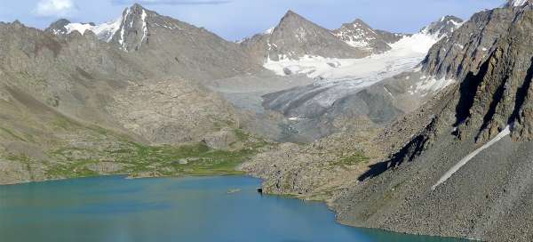
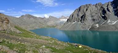
The first look at Ala kol
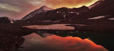
Finally, after 4.5 hours of ascent, a view of the beautiful Ala Ala Lake (3,520 m above sea level) opens up. Here, too, you can sometimes see a tent on a patch between rocks, but the legal camp is a little further. Yes you are at the lake, but it is not the end of the stage yet, the main view is still waiting for you!

Ascent to the viewpoint over the lake
The well-trodden path from the lake continues to rise (it is not possible to walk along the water)

View of the campsite at Ala's bike
The path leads further to the Ala kol pass, so if you are heading to a beautifully situated camp by the lake, follow the path carefully to turn at the right moment.

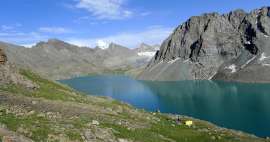
Glacier view
From the viewpoint, about 3,700 meters above sea level, you can also see the mountains and the glacier at the southeastern end of the lake. You can go back the same way, or you have to cross a pass (3,860 m above sea level) and go down to the adjacent Arašany valley

Articles nearby


Article: Karakol trek
Karakol trek is the shortest variant of trips to the Těrský Alatoo mountains. You will head directly to the main valley, which… continue reading