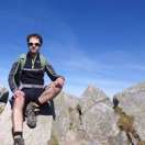
Ascent to Krakow stick
Circuit through Pusté and Sedlo pod Kúpeľom


Krakova hoľa lies outside the main ridge of the Ďumbier Tatras and with its height of 1,752 m above sea level it does not stand out in comparison with the peaks of the main ridge. So it's a bit neglected, but wrong. The top can be reached by several different routes. The route described below can be managed in about 9 hours, is about 18 – 19 km long and with an elevation gain of less than 1,700 m.
The first part of the route
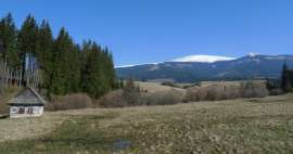
The route starts in the parking lot at the Demänovská Cave of Freedom. Parking is paid for, but if you go on this tour on a Monday when the cave is closed, there is a good chance that you will avoid paying. And as a bonus, you won't have to penetrate the tourists who head to the cave. It is possible to get here by bus. From the parking lot, we set off along a blue marked path along a steep slope around the entrance to the cave. As far as the road is paved, above the cave it becomes only a forest path, which zigzags down the slope higher and higher. After about 300 meters, we have the steepest climb behind us, followed by a slightly gentler climb. At the same time, the views of the opposite ridge begin to open. On the right you can see the pointed Sina (1,560 m above sea level) and on the left there are three peaks of Bôr (1,888 m asl), Zákľuky (1,914 m asl) and Poľana (1,889 m asl) close to each other.

Desolate
We are still climbing up and at an altitude of about 1,400 m above sea level the trees part and we find ourselves on a steep grassy slope below the Pusté peak (1,501 m above sea level). One of the most beautiful sections of the route with a beautiful view of the valley and the surrounding mountains. A number of rocks grow from the slope, between which we gradually ascend almost to the top of Pustá (the marked path slightly passes the top).

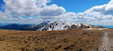
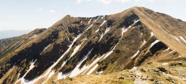
The top of Krakow is in sight
Then we descend a bit to the Machnaté saddle, where the yellow sign joins the blue sign on the left and together they lead us to the crossroads of Kosienka, Poľana. The road mostly climbs along a ridge, the western slope of which is overgrown with tall trees that limit the view. On the contrary, the eastern slope has been severely damaged by the storm and there are large deforested areas. We already see the main goal of this tour before us.

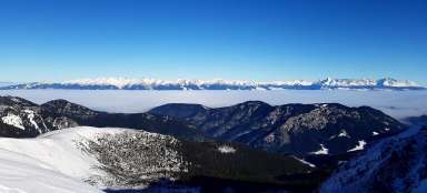
View from the top
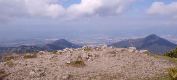
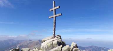
We continue to the crossroads Pod Krakovou hoľou. From here there is only a short turn leading to the very top. Krakova hoľa is overgrown with dense conifers, but at the very top, on the edge of the rock, there is a small free area, from where there is a beautiful view. We can see for example Poludnice, Pusté or Sinou. In the distance, the Liptovská Mara reservoir and, with good visibility, the High Tatras. In the mountain massif there is an extensive cave system with a total (so far known) length, allegedly up to 65 km. However, the caves are not open to the public.

Continuation to the saddle of the Front
From the top we return to the crossroads Pod Krakovou hoľou and then descend to the crossroads Kosienky, Poľana, where the yellow marked route separates. We continue along the blue to the saddle of the Front. The road leads mostly downhill, until just before the saddle it starts to climb a little again. In some places it is necessary to penetrate with conifers. At higher altitudes, before descending back into the forest, there are nice views of the surrounding hills.

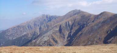
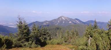
Poludnica
From the Predných saddle (1,415 m above sea level) we continue down the forest to a crossroads in the Pod Kúpeľom saddle (1,131 m above sea level). The imposing Poludnica (1,549 m above sea level) rises in front of us among the trees. The blue marked route leads to its top and so its overcoming is very tempting. However, according to the sign in the Pod Kúpeľom saddle, the journey to the top from this place takes an hour and a half, and even then we still have a long way to go to the starting point of the tour. So we leave the blue and then descend along the yellow to the Iľanovská valley.

Iľanovské sedlo
We descend the slope to the Iľanovianka stream and continue along a comfortable path along the stream to the crossroads behind the gates. The crossroads is at an altitude of about 850 m, so we descended from Krakow already by 900 m. Now, however, we are again waiting for about 400 m up to Iľanovské sedlo. At the crossroads, we turn left along a green marked footpath. In the same place there is a beautiful, wide, but unmarked forest path, which can easily lead an ignorant tourist off the right path. As it happened to me :-) Because this road leads in the same direction from the beginning as the marked road, it never occurred to me that I could go the wrong way. It wasn't until some time later that I became suspicious that I hadn't seen the green sign for a long time, so I checked my position via GPS and found out that I was a lot farther than I should be and the path I was following drawn on the map. The road really looks relatively new in this part. Fortunately, he soon turns in the right direction again and takes me almost to Iľanovské sedlo, only the last few hundred meters it is necessary to walk through the open terrain according to GPS. Compared to the marked road, I walked at least a kilometer, but on the other hand, this road was probably more comfortable and I had a beautiful view of Poludnice behind my back almost all the time. So you don't have to be afraid to try it.

The final part of the route
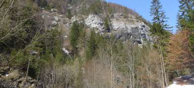
From Iľanovský sedlo we are mostly waiting for the descent still on the green. The route leads for the most part along the stream, sometimes directly through its bed. There are footbridges in some places and even chains in some places. At higher water levels, it can be quite an unpleasant section, but in nice weather, on the contrary, attractive. Nature seems quite wild here and with a little luck we can even hear a bear. We reach the Demänovská Cave of Peace, which is inaccessible to the public. A little further on, the stream that has accompanied us until now flows into the river Demänovka. And from there it is only less than a kilometer on a comfortable path upstream of Demänovka back to the parking lot from which we left.

Articles nearby


Giga List: The most beautiful hikes in the Low Tatras
In the Low Tatras you will find perhaps the most famous ridge in Slovakia and at the same time the most beautiful views of the… continue reading