Ascent to Chopok and Skalka
Or five peaks in one day


Visiting Chopok is almost the duty of every visitor to the Low Tatras. The easiest way to get to the top is by using a system of cable cars either from the north or from the south. The upper station of the cable car is only a few tens of meters from the top. For those who prefer to climb the mountains on foot, there are several marked trails. Below is a description of the circuit from Demänovská Dolina, during which, in addition to Chopok, we will conquer 4 other peaks. The route is a little over 22 km long, with an elevation gain of less than 1,700 m and takes about 9 hours.
Vrbické pleso
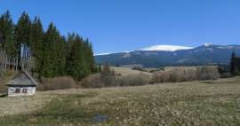
The hike begins in the village of Demänovská Dolina, in the local part of Jasná, which is full of guesthouses, apartments and hotels. In September 2018, however, it is half abandoned in the morning (even when returning late in the morning) and rather than tourists, it is possible to meet construction workers working on the construction of other accommodation facilities. There are several car parks and a bus stop on site. From the stop we head along the yellow and after a while we are at Vrbický pleso – the largest natural lake in the Low Tatras. It is the largest, but still relatively small. In the distance above it is the three-peaked ridge of Bôru – on the right is Bôr itself, on the left are Zákľuky and in the middle there is probably an unnamed peak (no guarantee).

NCH Demänovská dolina
We will bypass Vrbické pleso and return to the asphalt road for a while. From the crossroads Mikulášská chata we continue along the yellow road. The Demänovská dolina Nature Trail also runs parallel to the yellow. Unfortunately, even here there was a calamity and a large part of the surrounding slopes remained bare. Far ahead we see the Poľana saddle, where we need to get. Fortunately, the asphalt soon ends, the road turns into a forest path – initially without a forest, but then it sinks among the trees that survived the calamity. The forest road is gradually changing into a wider footpath, pleasantly ascending around the stream, and after less than 45 minutes we are already at the crossroads of Tri vody at an altitude of around 1,370 m.

Ascent to Sedlo Poľany
At the crossroads, the nature trail, together with the red sign that starts here, turns right. We continue straight on along the yellow. The road is broken in places. We will soon get above the forest line. In front of us we see Poľana and the saddle, looking back we have behind us the massif of Krakow's top: [https://www.gigaplaces.com/…rakovu-holu/], Pusté and in the distance with good visibility it is possible to see to the High Tatras. The trail is constantly ascending and after about 80 minutes (from the crossroads of Tri vody) we are in Sedlo Poľany at an altitude of 1,837 m above sea level.

Saddle Poľany
We reached the main ridge of the Low Tatras. If we would like to shorten the hike significantly, it is possible to turn left after the red road to Dereš and further to Chopok. Otherwise, we will continue to the right along the yellow and parallel red on Poľana. There is a beautiful view to the south from the saddle, so we can get a picture of what awaits us now. On the right you can see the ridge between Poľana and the Kotliská peak, along which the trail leads and on the far left is Skalka.

Poľana
So we continue to the right from the saddle and after approximately 500 meters we are at the first peak of the route – Poľana (1,889 m above sea level). The top itself is not significant, it is marked only by the old triangulation rod. But even from here there is a beautiful circular view, including the Zákľuky (1,914 m above sea level), where it is possible to walk along the yellow hiking trail.

Cross saddle
From the top we continue to the left along the red road to Krížské sedlo. The road descends along the ridge to the saddle at an altitude of about 1,760 m above sea level. There is a blue-marked turn in the saddle leading to Liptovský Ján. We will still stay red and start climbing again to the second top of the route – Kotliské.

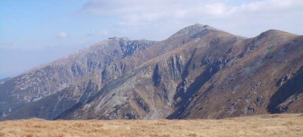
Boilers
After ascending about 180 meters above sea level, we are at the top at an altitude of 1,937 m above sea level. The top is again marked by a triangulation bar and there is a beautiful view from all sides. The most interesting is probably the view to the north – right in front of us is the ridge we came after, behind it to the left Bôr and Zákľuky, in the middle of Poľana and to the right the ridge continues through Dereše and Chopok. On the far right, a little aside, will probably be Ginger: [https://www.gigaplaces.com/…vske-doliny/]. The red sign continues to Chabenec and Ďurková, here we turn left onto the yellow marked route towards Skalka (in the period from 1 October to 30 June, entry to this path is prohibited).

Skalka
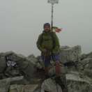
First we descend a little to the nameless saddle, pass the nameless peak and start climbing again until we reach a damaged indicator, which is not at the very top. The yellow-marked route turns southwest and continues to Žiarská hoľa. If we want to reach the very top of Skalka (1,980 m above sea level), we must continue from the sign in a south-easterly direction along the top plateau until we reach the half-upturned triangulation bar. It's hard to say if it's really at the highest point of the platform, it's hard to determine here, but I think we can declare the third peak as good as we can.

Back to Sedla Poľany
Since the main goal is Chopok and we also want to return to Demänovská Dolina, there is nothing left but to return to Sedlo Poľany along the same route. The journey takes about 1.5 hours. Once again, among other things, we pass the nameless peak between Skalka and Kotliska, along the grassy slope of which there is a comfortable footpath.

Dereše
From Sedlo Poľany we turn right along the red road. The road gradually climbs the ridge. In some places it is rocky, in some places there is a stone walkway. It is no exception to meet a group of chamois here. As we approach Chopok, there are more and more people. Even before Chopok, we reach the top of Dereš – the fourth highest peak of the Low Tatras and at the same time the fourth peak, now conquered. According to the map, the altitude is 2,003 m, according to the signpost at the crossroads, which is a little further (and below) even 2,004 m.

Chopok
Now we are missing only the last and at the same time the highest peak of the route. With an altitude of 2,024 m, Chopok is the third highest peak of the Low Tatras. From the crossroads we continue along the red ridge path and soon we are at the upper station of the cable cars – you can get here from the south and north side. It's also a bit livelier because of the cable car. Directly below the top of Chopok is a modern cottage with a restaurant. We are only a few minutes away from the top. There is a wonderful view from above, as well as from the whole ridge.

Descent down the piste
From the top we go back to the cable car station, where there is a crossroads. Following the red road, it is possible to continue to Ďumbier, to the south the yellow road leads to Kosodrevina and Srdiečko. We will head north along the blue towards Luková. The trail in this section leads along the ski slope and runs relatively quickly. We leave the main ridge behind and deep below we have the Demänovská valley.

Under the Eagle Rock
Following the blue line, we still descend across the Luková and Pod Orlou skalou crossroads. For a while, the blue and nature trail will be added to the blue, but we still stick to the blue until Jasná, where we left in the morning. Under the crossroads Pod Orlou skalou, we dive into the forest for a while, but unfortunately even here, large areas are damaged by calamity. The last section is again on the piste. At the edge of Jasná, the blue sign turns left and leads around the Vrbický lake, but it is also possible to get to the car park by a shortcut along the road through the village.

Articles nearby


Giga List: The most beautiful hikes in the Low Tatras
In the Low Tatras you will find perhaps the most famous ridge in Slovakia and at the same time the most beautiful views of the… continue reading