Ascent to Ďumbier from Demänovská Dolina
The highest peak of the Low Tatras


There are a lot of possibilities to go to Ďumbier. For less able tourists, it is probably the easiest way to take the cable car from Demänovská Dolina to Chopok, from there up the ridge path to Ďumbier and return in the same way. From the south side it is possible to set off from the Čertovica or Trangoška or Srdiečka saddles, for example. This article describes a hike from the north side, from Demänovská Dolina. The route is about 17 km long, with an elevation gain of about 1,400 m and takes about 8 hours to complete.
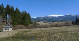
Wide valley
Demänovská Valley with a large „D“ is a large village, which consists of several local parts scattered in the Demänovská Valley with a small „d“. The route starts in the local part of Lúčka, at the beginning of the green marked hiking trail. There is a bus stop right next to the trail and a short distance away there is a large car park used probably in the winter, as there is also access to one of the cable cars of the Jasná Ski Center. In mid-September 2018, however, the parking lot was empty despite the beautiful weather. So we will follow the green sign to Široká dolina. Simultaneously with the green sign, the Demänovská dolina nature trail also runs across the entire Široká valley. At first, the trail leads along a wide, only slightly ascending, comfortable path along the Demänovka river. We will soon reach the crossroads Pod Krčahovom, where the red-marked trail begins / ends, along which we will return. Not far from the crossroads, there is a turn from this trail to the guerrilla bunkers, hiding about 100 m higher on the slope. But we will continue to go green. The road gradually deteriorates and is driven by heavy machinery. Unfortunately, a large part of Široká dolina is a bit depressing. The slopes around the road are probably bare after a wind and bark calamity. Only after less than an hour of walking we finally get to the places where the forest is undamaged. The wide road becomes a footpath, in some places quite rocky and after a while we stand at the crossroads of Záver Širokej dolina at an altitude of 1,416 m above sea level.

Above Široka dolina
Here, an educational trail leaves us, which, together with another red one, turns right. We keep climbing up the green, the trees gradually thin out and turn into cypress trees, which also gradually recede. The path in this section is formed by a comfortable stone walkway. The higher we climb, the wider our view opens up. Looking back, we have the Konská peak on the left (out of focus), behind the slope of which the Chopok promontory peeks out, and in the distance to the right of it, Sina can be seen.

Pearl barley
The slope is getting steeper and steeper and the stone walkway turns into a well-trodden path, which climbs upwards in a „zigzag“ style. We will soon reach the crossroads Pod Krúpovou hoľa, where green intersects with yellow. We still continue along the green to Krúpová sedlo, from which, according to the sign, we are only 15 minutes away (and approximately 100 altitude meters). A few tens of meters in front of the saddle we pass the very top of Krúpova hoľa (1,922 m above sea level). The place has a beautiful view in all directions. In the photo below, in the foreground is Krúpova hoľa and behind it in the background Konská, Chopok with the cable car and behind him probably Dereše.

Along the ridge to the top
From the saddle, follow the red road to the left to the last section of the ascent to Ďumbier. We have only the last kilometer of slight ascent ahead of us, partly on the sidewalk, partly on a footpath, sometimes over rocky seas.

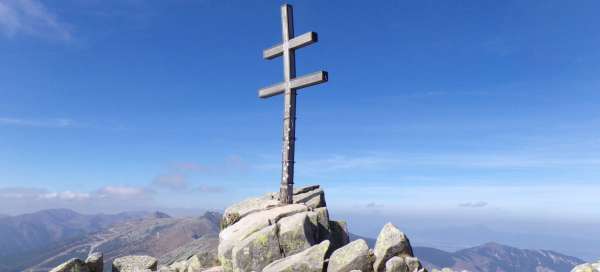
Top
After about three and a half hours we are at the top. In addition to the double cross, there is also an interesting stone obelisk on top. With a height of 2,046 m, Ďumbier is the highest mountain in the entire Low Tatras.

View from the top
There is a beautiful view from the top in good weather. Looking to the north, on the left you can see the ridge descending from Krúpova hoľa, where another part of the route leads through Prašiva, in the middle is the ridge of Ludárova hoľa and on the right the slopes of Štiavnica. In the distance, the peaks of the High Tatras are lost.

Štiavnica
Right next to Ďumbier is the second highest mountain in the Low Tatras – Štiavnica (2,025 m above sea level). Theoretically very easy to reach, but practically forbidden for tourists, as it is in an area with no entry.

Back to the saddle
At the top of the red tourist sign ends. If there is snow, it is possible to continue to the cottage of Milan Rastislav Štefánik, otherwise it is necessary to return to Krúpov saddle along the same path that we came.

King's table
Another point on the route is the crossroads of the King's Table, where an attractive, unmarked abbreviation, trampled in the grass, leads from Krúpova sedlo. However, if I remember correctly, there is a ban on entry, so it is better to continue along the green back to the crossroads Pod Krúpovou hoľou and here turn right on the yellow marked path, which after a while will take us to the King's Table. Attention – this route is accessible only from 1 July to 30 September. The trail descends along a grassy ridge, a little lower to the right you can see the peak of Prašivá, behind it Krakova hola: -ascent-to-krakovu-holu /] and a not very significant Dancer between them.

Dusty
After approximately 700 m of gradual descent along a grassy ridge with a wonderful view of the surroundings, the trail begins to descend a little steeper and at the same time begins to sink into the cypress stands. In front of us is a shallow saddle and behind it Prašivá (1,679 m above sea level). The marked route passes the top itself by several tens of meters, but it is still overgrown with cypress trees. However, just below the top, there is a nice stick directly inviting to a short sitting, refreshments and gaining strength before the next trip.

Dancer
Another peak near the route is Tanečnica (1,681 m above sea level), which, however, goes around the marked route at a slightly greater distance. The peak is located in NPR Ďumbier and is therefore inaccessible. The last short ascent from the saddle between Prašiva and Tanečnice on the slopes of Tanečnice awaits us, and then we will just descend to the end of the tour (if we do not get lost).

Hillside Dancer
The road travels largely through a forest-free slope, from which there is a beautiful view, especially of the Krakow Massif. Unfortunately, it is also good to see the glade caused by the calamity in the local forests.

Javorie saddle
Broken, uprooted or dry trees have been largely removed, but as we approach the Javorie saddle, we reach a still unprocessed field (as of September 2018). It is not possible to continue along the marked path. Fortunately, the saddle we need to get into is already in sight. After a while, we find a muddy path trampled in a thorn among the fallen trees, which looks like it could lead us to the saddle, so we continue along it. However, we soon find out that it has led us in the wrong direction, so there is nothing left but to ascend again about 80 meters above the steep slope we have just descended to get to the saddle. This time, without a path, we cut through thorns and tall grass. We will soon find a red sign on several broken trees, which leads to the saddle from the east, but it is not possible to talk about the fact that a path leads here. With a few scratches, we end up in the saddle.

The final part of the route
Yellow and red marked hiking trails cross in the Javorie saddle. We will continue along the red road to the west, to the crossroads Pod Krčahovom. On the western slopes, the calamity is almost processed, the slopes are bare and hot in the afternoon sun. It's not a very nice sight. After 2.5 km of descent, we finally reach the crossroads Pod Krčahovom, where we connect to the green tourist route, which we followed in the morning and which will take us back to the starting point along a comfortable path.

Articles nearby


Giga List: The most beautiful hikes in the Low Tatras
In the Low Tatras you will find perhaps the most famous ridge in Slovakia and at the same time the most beautiful views of the… continue reading