Travelogue How I Didn't Climb the Nebelhorn
(but on Niedereck)

Niedereck is a saddle on a ridge between the peaks of Rubihorn and Gaisalphorn, separating the valleys of the streams Faltenbach and Gaisalpbach.
Across the Niedereck saddle
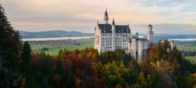
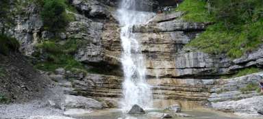
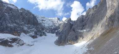
Nebelhorn is an alpine hill in the Bavarian Allgäu region, reaching a height of 2224 meters. You can climb it from the town of Oberstdrf (also known for its ski jumps and races on them) or you can enjoy the cable car. But this year, its reconstruction has somewhat shuffled my plans to conquer the summit or at least the second transfer station. It all ended a little differently. But pretty well. The second Sunday in September was in the promise of beautiful weather. Temperatures around 22 degrees and clear, which is a condition in these mountains for the complete success of the expedition. The journey from Dingolfing (my place of residence) to Oberstdorf takes about 4 hours by train and I paid € 25 for a Bayern Ticket (all-day ticket), which is quite a favorable price. We also arrive in Oberstdorf basically according to plan, although Munich has been driving slowly for a long time, due to a failure of the security system. And so around half past ten we arrive in a typical alpine town under the mountains. The station in Oberstdorf is relatively large by local conditions, similar terminals usually have a maximum of two tracks, but due to the fact that large sporting events often take place here, and the Germans like to use the railway for these races, there is a five-track terminal. After buying souvenirs in the station building, I follow the arrows on the Nebelhornbahn, ie to the cable car, where the marked path to the mountains actually begins. The route through the town, purely recreational with many hotels, cafes, restaurants, and typical alpine houses with carved balconies full of flowering hibiscus, takes about 15 minutes. But instead of building a cable car, I only come to the construction pit and the information center of this traffic construction. It is undergoing reconstruction and will be opened as a cabin for Easter 2021. Anyway, my plan was to walk, so I'm leaving. After the bridge, I cross the Trettach stream and continue to a neighborhood full of guest houses towards the aforementioned ski jumps. Here I learn information that not all roads to the first Seealpe intermediate station can be used due to the reconstruction of the cable car, but that the restaurant is open. So I choose to climb the local road (you can still walk along the waterfalls on the Faltenbach stream, but I wanted to return). The road starts from the ski jumping area and partially underpasses its grandstands, which will be filled especially around the New Year, when a tour of the four bridges takes place here. The operation of cars with a permit is controlled by traffic lights, but the intervals are about 20 minutes. On the first serpentine, the path to the waterfalls disconnects from here and I start to climb. The climb is not steep but quite long. The road is passable for bicycles, but during construction work only on Saturdays, Sundays and public holidays. At the first crossroads, turn right and choose a safer road in front of a marked path that connects after a few hundred meters. In the next serpentine, the views of the ski jumping area begin and the emergency supports of the ropes of the cable car can be seen. In the next sharp turn of 180 °, the above-mentioned trail is to be connected, but it is strapped and with a warning that it is alpine terrain. Not to mention that I didn't go this way. I continue down the road in two more serpentines, where I meet locals repairing electric fences for grazing cattle. There is also a traffic light that divides the section on Seealpe into two sections. Here, the ascent also slows down and I continue almost straight to the point where the trail joins the waterfalls. Under normal circumstances, I would turn off the road here and continue 400 meters to the restaurant, but like almost everything, it is closed due to the above. The road is a bit longer, but quite comfortable. Right in the first turn, I cross the Faltenbach stream with a bridge, on the hill above the bridge the newly built cable car support switches off and after a few tens of meters I come to the place where parts of another support waiting for installation are stored. The road continues with a few more serpentines until I come to an open restaurant with a garden at an altitude of about 1270 m. The beer with a view of Oberstdorf tastes good, but due to the fact that the whole valley further to Nebelhorn is closed, again due to the construction, I decide what to do next. Before the option to go back and walk through the villages around Oberstdorf, the second option wins, climbing higher. In the end, the only possible way forward is the red-marked road, whose signposts point to the Rubihorn and a time of 2 hours. Right next to the restaurant, the former cable car station is being reconstructed and the cable car station is almost built. Not far from here, among the pastures, all the old cabins of both sections of the cable car await their fate. And I follow the sign. But not far from the station, this road is also re-laced and there is a yellow warning sign to close the road. However, because there are a lot of tourists along this route, and because this ban reminds me more of winter signs warning of avalanche dangers, I go on. The route first leads almost almost along the contour line and after some 300 meters the closure ends and as I subsequently find out, this section can be bypassed by a traversing path directly from the restaurant. I didn't know that, so next time. Through a special gate for tourists, I enter the paddock of the locals, all day chewing on the rich clumps of alpine grasses, with the constant ringing of bells audible even far away in the valley, then turn the grasses into milk and can appear in commercials for great local chocolate delicacies. That is, not only the inhabitants, so as not to be accused of gender imbalance, there were donkeys among them. I walk through the pastures with a little respect, although the local cows pretend that they are not interested in anything but food, and that they intend to move only when they completely graze the space around them, but not the other side, if some wanted to run, I think I would in this terrain he didn't have much of a chance. Fortunately, I approach the local wooden shepherd's house and begin to climb over the pastures. And you will discover the first really nice views of the town of Oberstdorf and its surroundings. The trail begins to climb zigzag along the ridge. This is followed by a plain with several trees, where you can find shade, but then the ascent through the local conifers begins. I don't know what to take pictures before, because every serpetinka offers a new view of the valley. Such lacing through the valley will bring the tourist some 350 meters above sea level. Here, however, the relatively comfortable footpath ends and begins an uncomfortable climb along a path full of large stones, and in several places secured by chains and metal steps. Fortunately, this condition does not last long and I come to a ridge with a crossroads. The dwarf signpost placed on the stone indicates another half hour to Rubihorn. From the ridge, however, there is a wonderful view of the valley with the Gaisalpsee lakes, and the peaks of the Nebelhorn, but also of the Gaisalphorn (1953 m above sea level), where an unmarked trail leads from there. I wonder whether to go back or go further, but after seeing the trail that tourists climb from the second valley upwards, it is decided. I don't know where I will go (I'm without a map), but I'll definitely get on the train somehow. I will also specify that the crossroads where I climbed is called Niedereck and its altitude is 1867 m above sea level. After a short rest, I continue. It is relatively slow, because the terrain is rocky and here and there it is necessary to use chains, or give preference to opponents (so I mean those who have chosen the opposite direction). I continue on the comb for about 20 minutes, but I cheer after a while. I see a crossroads in front of me with a path that I plan to take down. From here it's only 15 minutes to Rubihorn, but I don't know if there will be enough time for the trip, so I prefer to go down the valley. Not far from the crossroads is a monument to one of the victims of the local mountains. I descend slowly along a stony path (be careful, stones run here and there) towards Unterer Gaisalpsee. The road is called Gaisalpsteig and winds just like the one from Oberstdorf. I keep descending into the valley while taking pictures. On the opposite slope you can see a rock overhang, above which stands a hut (possibly an emergency dormitory, I do not know it from that distance), which is on the way to Oberer Gaisalpsee (second lake in this valley) and further to the top of Geisfuss (1981m.nm). Under the cottage you can hear the water flowing and really. The rock is wet for a few meters, the waterfall is not directly visible, but the water probably supplies the lake to which I am heading. Unterer Gaisalpsee is a mountain lake at an altitude of about 1500 m. Unfortunately, in the late afternoon there are bad light conditions on my part, but like everywhere in the Alps … it's nice here. Here, at last, the road leads along the plain for a while. They watch tourists who use the sun's rays to catch bronze, and a few daredevils try a few tempos in the local, probably not very warm water. If I thought the way from here would be a walk in the rose garden, I was wrong. Once again, the relatively rocky path continues, in several places it is necessary to overcome local streams, which are not large at all, but there are usually slippery wet stones, which need to be watched. On the way between the low trees you can also see the waterfalls, which are located under the ball, from which I descend. From Gaisalpsee to the Geisalp crossroads (to the road) it takes about an hour according to the signpost. Chains and several metal steps are still waiting for me on the way. The views are already limited mainly to the Gaisalp valley. Just above the signpost in Gaisalp, I register two mountain restaurants, even the signposts in the valley, which point to them, contain information on whether they are currently open or not. At the signpost, the road is divided, I can either go to Reichenbach or traverse the slopes to Oberstdorf. The second option wins. Following the road, with which I complete two serpentines, I descend to the chapel, where my path separates from the one to Reichenbach and begins to traverse, or rises slightly along the slopes of Rubihorn. It mostly leads through the forest, but here and there there is a view of the villages around Oberstdorf. Only about 2 km from the chapel, the path begins to slowly descend and still holds the direction of the traverse. It crosses the Rossbichlbach stream and changes direction in front of Oberstdorf to descend to the café (the presence of which is already indicated by the signs at the chapel) and then join the road, which I started to climb to Seealp in the morning. Now I just walk around the bridges, under them I had a somewhat funny situation, when the radar measured me on the local roads, even though I was walking. It was all the happier that a maximum speed of 5 km / h was allowed here and I really went for it. Then just walk through the streets of Oberstdorf and for the next 4 hours the train will rock me home. The whole route took about 7 hours of free pace and with stops. The elevation gain was about 1100 meters up, and the same when descending.
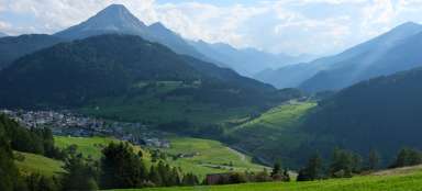
View of Oberstdorf
The rising serpentines open up new perspectives

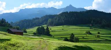
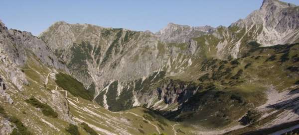
The alpine views are always pleasing
This is where the serpentines begin before climbing Niedereck

View to Seealp
As the altitude meters increase, the views increase

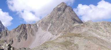
Crossroads below Rubihorn
Here I went back to the valley

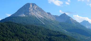
View to Nebelhorn
There are amazing views from the crossroads below Rubihorn

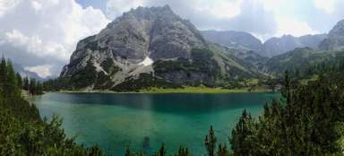
Unterer Gaisalpsee
The descent in the early evening complicated photography a bit under the long shadows.