
La Graciosa by bike
An island that is easy to bike

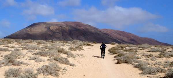


The small area of the island (length is 8 km and width is 4 km) makes it easy to explore. The streets and roads of La Graciose are mostly made of unpaved sand. There is therefore a choice to go on foot or to rent a bicycle. There are even a few cars on the island, but their number is strictly regulated. Thanks to this, it is possible to rent an off-road car with a local guide. We were interested in all these attractions, which is why we decided to explore this northernmost and smallest inhabited island in the entire Canary. We set aside one day and decided to explore it by bike
By ferry to the island
The island can only be reached by ferry from one of the two shipping companies from Orzola to Lanzarote. We did not let ourselves be discouraged by the strong wind and we set off in the morning. A smaller ship was swaying in the small port, there were few passengers and we could buy tickets quickly without any problems. The ride only takes about 25 minutes, so we don't expect any problems. However, right after leaving the pier, we learned what a strong wind can do to the ocean. The ship sways from side to side and slowly slides through the high waves. Fortunately, this ride, which is not unlike a roller coaster, calmed down after about 10 minutes, as soon as we reached the lee of Graciosa Island, and we sail to the only port on the island.

The port of Caleta del Sebo
The port village of Caleta del Sebo in the south is one of the two inhabited places on the island. It is the only place on the island where the visitor can get water or something to eat. The second place is the settlement of holiday homes Pedro Barba, which is located in the east. We get off the ship and look around the sleepy harbor. There are a few tourists in the local pubs, and apart from a few places with tourist services and bicycle rentals, there is nothing in the port. We walk a bit indecisively through the port and the dusty sandy streets. In the dusty streets we find a church, museum, post office, shop and school. Sandy paths begin right behind the last houses and the peaks of local volcanoes rise in the distance. We have confirmed that we do not intend to walk on the sand and return to the alleys, where many locals earn extra money by renting bicycles. We despised fashionable e-bikes, got some advice on the trip and a map, and we set off.

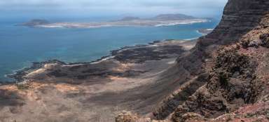
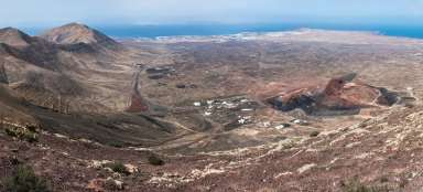
Arid island
There are only a few desert bushes around the sandy path. After about 1.5 km of gentle ascent, we reach the only fields on the island, which crouch in the lee of the highest local mountain Agujas Grandes. Although this stratovolcano reaches a height of only 267 m above sea level, it also has a massive impact on a small island thanks to the crater's diameter of around 400 meters.

Baja del Ganado beach
From the crossroads of dirt roads, a slightly paved road leads down slightly to the beaches of the west coast. After about 2.5 km we reach a turnoff to the local interesting beach Baja del Ganado. We will enjoy the local calm atmosphere, but we will not stay long, because we know that the best beach is just in front of us.

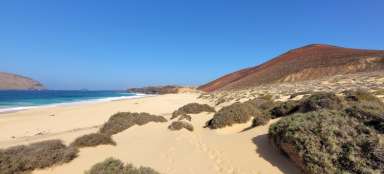
Playa de las Conchas beach
And indeed, after about 1.5 km of sandy roads we reach the local famous beach Playa de las Conchas. We leave our bikes in the parking lot and wade through the sand to the beach. After about a hundred meters, a stunning view unfolds in front of us. About 600 meters long and up to 120 wide beach with fine yellow sand, above which rises a volcano. The water is cold and the waves relatively high. Therefore, we prefer to lie on the beach before swimming, and in addition to snacks, we enjoy the view of the stormy waves and the rocks of the opposite island.

Dangerous sea currents
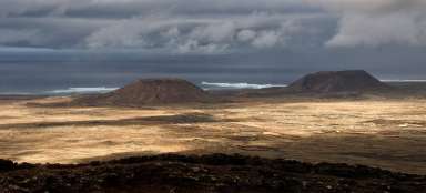
This beach is the destination of most one-day visitors to the island, whether they arrive on foot, by bike or by car. And it's really worth it. More able tourists can diversify the trip by climbing the adjacent Bermeja volcano, from which you can overlook the north of the island, including other islands of the Chinijo archipelago. We watch the massive foaming waves and realize the dangerous power of the local coastal currents. A local memorial plaque commemorating the tragedy of December 26, 2013, testifies to what they can do.

Rock arch
Because we are only in the middle of the planned circuit and we must not miss the last ship back to Lanzarote, although we do not like to get up and set off on our bikes. After 2.5 km we reach a crossroads, where a couple of bikes are already lying and there is even a parked jeep. There is no sign, but we know from the map that a short distance down the trail is a large rock arch above the sea. After about two hundred meters walk along the rocky desert trail, we reach this local attraction. It is about a thirty meter long rock gorge, which is decorated with a beautiful natural stone arch at the point of contact with the high seas. The roar of the waves rolling through the gorge and crashing into the rocks again warns us of the enormous power of the ocean. We carefully lean over the rock edge and try to take pictures of this extraordinary natural theater.

Beaches in the north
We just do not like to return to the crossroads, from which we continue further along the coast to the southeast and pass the local rocky beach.

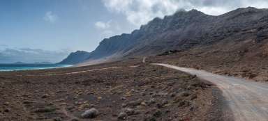
Settlement Pedro Barba
The road begins to climb gradually to the saddle above the settlement of Pedro Barba. It is a cluster of nice looking holiday homes with an adjacent beach. Due to its location, the settlement is leeward. An ideal place for a very quiet stay.

Sandy roads
We are passing a lonely jeep, which is struggling with a rocky-sandy road. We step back from the narrow path and watch him disappear in the dust towards the northern beaches. We will be waiting for the serpentines on the saddle, from which there will be a long descent to the famous crossroads under the Agujas Grandes volcano. We will drive along the modest fields again and see the wind screens and the irrigation water reservoirs. It is really not easy to grow something in these conditions. The last section back to the town is already known as a sandy trail, but this time we are going comfortably downhill. We are completely dusty and we don't want much further research on the island.

Harbor comfort
It is still necessary to explore the southern beaches of Frances and Cocina, but you can't go there by bike. So we regret the beaches and the view of the Yellow Mountain (Amarilla Mountain), which is four kilometers away, and we prefer to sit in the port café. After all, getting to know and traveling also includes calmly soaking up the local atmosphere and looking at the natives and multi-day visitors, who have obviously adapted to the local lazy pace. No one here deals with free-standing bikes and e-bikes standing on the streets. Well, the old days still rule here! Coffee is as excellent as on other islands. Unfortunately we do not have time for local fish specialties, because we have to catch the afternoon ferry back.

Take the ferry back
So we quickly finish our coffee and together with several surfers and a small group of returning tourists we embark on a cruise back. The end of the voyage is again more adventurous due to the big waves, but we are so full of impressions that we do not admit this adrenaline experience so much. Gracioso can be translated as elegant, funny or charming. After spending a very pleasant day on this island, we can confirm that the name is tight and the island is definitely worth a visit. Let's hope it continues to have its own special atmosphere.

Articles nearby


Tento ostrov je dosť preceňovaný. Krásne pláže to hej, ale všade veľmi veterno a samý prach a piesok všade, v očiach, ušiach..., bicykel dostal defekt, takže bol skôr na príťaž. Za dosť vysokú cenu plavby a zabitý celý deň to nestálo. Na Lanze je veľa zaujímavejších miest k návšteve.