Article Ascent to Massanella
The second highest mountain in Mallorca


1364 meters in height determines the second place in the competition for the highest mountain in Mallorca. In clear weather, you can verify that you are really on the island. And you will certainly not be disturbed by anyone.
Massanella
Mallorca's second highest mountain
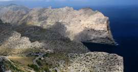
The highest mountain in Mallorca is Puig Major with its 1436 meters. However, you won't get there, that is, unless you are participating in some international military exercise. The top of this mountain belongs to the army and there is a building visible from afar with a dome serving either meteorologists or as a radar. So, if you want to climb as high as possible, you have no choice but to take the second highest mountain – Massanella, which is 72 meters short of its higher sister.
The old pilgrimage route to the Lluc monastery
The hikes usually start in the saddle near the Lluc monastery, which is located on the road connecting Soller and the town of Polenca, at an altitude of less than 600 meters. Several bus lines also go here. And it was the insidiousness of the schedule in Spanish that caused the bus coming from the town of Inca to drop us off in Caimarí, thus extending the entire route by about 6 km and 400 meters of altitude. Well, we're not going anywhere. In the pocket with a guide about Mallorca from Freytag-Berndt publishing house from 2003 in the Czech language, we meet more than a kilometer of elevation gain. We set out on the road leading in the same direction as our route, but we leave it immediately after the village at the rest stop and continue on a stony path slightly uphill. The guide states that we are moving along the old pilgrimage path to the monastery. The legs also have to get used to the fact that the gradually rising path is alternated here and there with stairs. However, the path is relatively well marked at the turns (mainly where we cross the road) with a table with a picture of a tourist, the name of the destination and a time value.

Ascent to Coll de sa Bataia
After about two kilometers, the first crossing with the road awaits us, and the road starts to climb steeper. At the solitude of San Costa we are greeted by a flowering cactus, just as in Caimarí we gazed at the lemon trees in the gardens. Again we stop by the road and here the description in the guide confuses us a little, it indicates a continued journey up the road, while in the terrain the signs return us descending towards Caímarí. But only to the first road bend, where we once again change the asphalt to a stony surface. After overcoming the ladders (applied in a number of places, as the tourist climbs over, but the grazing cattle do not overcome), we continue along the path, which is indicated on the map as GR 222 Ruta Alta – Lluc. She really got a lot of stones in the wine, so we are a little surprised that a group of cyclists on mountain bikes rushes towards us. Nothing against the taste, but they probably have a good insurance policy. Views of both Mount Massanella and down to Caimari begin to appear gradually. We have about another 2 km behind us and the road joins us at the Refugi hut, which was listed in the guidebook as the right one. While at the beginning of the route the road was still above us, now it is already deep in the valley and it will catch up with our height subsequently with several switchbacks. We open the gate across the next lot and pass a building under construction to the turnoff to Massanella. However, we still pass it and go down to the road to a place with a gas station and a restaurant, and that's only because we are leaving the oldest member of the expedition here, who did not expect a prolonged ascent and was worried about being able to manage the next trip. The place is called Coll de sa Bataia.
Ascent to Coll de Coma Freda
We go back the same way until the turnoff to Massanella. On the way, I still notice the spring on the right side. We continue with a slight ascent from the crossroads in the direction of the wooden marker, until we are stopped after about one kilometer by a fence and a classic ladder to overcome it. Just beyond the fence is the shack of the local area administrators who, according to the guidebook, should collect the „toll“ for entry. Considering that during the entire time we will meet only 6 (in other words, six) similar „tourist lovers“, probably the trip to work and the drinking regime would probably cost these collectors more than the income from the entrance fee itself. And we are said to be following the most frequented route in Mallorca. The path continues past a former farmhouse and along a stream marked on the maps as Torrent de Comafreda and actually the only bed that functioned as a stream during my visit to the island. Here you need to pay close attention to the markings – don't look for strip marks here. It seemed to me that a painter was walking in front of us with a leaky can of red paint that dripped here and there on the stone. And to make one's head even more confused, without any warning, red turns to black. Well, you need to have a little imagination and a good sense of direction. At the end of the farm, just when the red marker started to be „masked“ with black, we go around the gate from the left side and the climb begins. The path then brings us through another gate to a forest path and after another climb in switchbacks we arrive at the saddle of Coll de Coma Freda with a stone marker. We are interested in the engraved arrow with the inscription Puig.
Pla de Sa Neu platform
We climb further along the red „drops“, but here the path is clearer than the previous part through the farm, and after about half an hour we reach Avens de Cami, where a stone marker indicates the path either directly to the top or to the top, around the spring. The first option is indicated by the guide as easier, so we choose it. The stony path meanders between the grasses and climbing tourists are „watched“ by stone men. Steadily climbing, we reach the Pla de Sa Neu plateau, from where we can already observe the summit. But be careful, choose the right one. Of the three peaks, ours is the middle one. If we look around a bit, we find that in the hill on the right there is a tree that had the honor of making it into the guide.

You can enjoy it already on the way out
The boundary of the forest here ends at approximately 1000 meters above sea level. Then there is nothing else to do but admire.

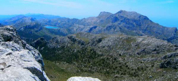
View from Massanella
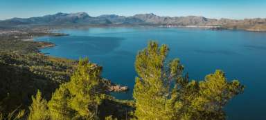
The metal table nods to us that we are right. 1364 meters high and a wonderful view, opposite of course the unmissable Puig Major, the Tramuntana and Serra mountains, the more distant destinations are a bit hazy, but we can still make out the north-eastern coast of Mallorca (Alcúdia, Playa de Muro, Can Picafort), to the left of the highest peak the Gorg dam Blau, serving as a reservoir for drinking water, and actually if we focus a little further, we find out through the haze that we are simply on an island and the coast can be seen in the distance in all directions.

Return
After this permitted visual doping, we return by the same route, because unfortunately we did not find the turn to the spring. Even so, it was a wonderful ascent, the June temperature was around 24°C and we kept to the indicated 4.5 hours for the return trip from the Lluc saddle. The unplanned extension cost us about 2.5 hours of extra time. We made the trip back in 2009. The link to public transport in Mallorca is www.tib.org , where you can find timetables and current prices. For example, a bus from Inca to Caimarí costs €2.40. The last buses to Inca and Soller depart from the village of Lluc before 6 p.m. Good luck to you
If you would like to stay in this beautiful mountain landscape around Sollér, there are a number of interesting places with a swimming pool and a view of the mountains. For example, Can Estaràs can be a secret tip
Articles nearby


Giga List: The most beautiful tours in Europe
Although Europe cannot boast such high mountains as other continents, you will still find beautiful hiking trails and ascents. In… continue reading
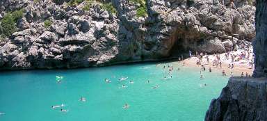
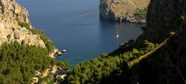
Giga List: The most beautiful tours in Mallorca
Mallorca is not only beautiful beaches, but also rugged and diverse mountains, peninsulas and high cliffs. Surprisingly, you will… continue reading