Ascent to Jizera and Smědavská hora
Across the Frýdlant battlements


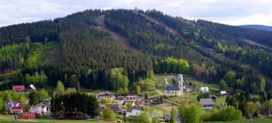
Jizera, the second highest mountain in the Czech part of the Jizera Mountains, is most easily accessible from Smědava. However, much more interesting (and also a little more demanding) is, for example, the ascent from Hejnice described in this article. In addition to Jizera, we will also conquer Smědavská mountain and visit a lot of beautiful views. The circuit is about 22 km long, with an elevation gain of less than 950 m and can be managed in about 7 and a half hours.
Beginning
The start of the route can be chosen either in Hejnice or in Bílý Potoc. Follow the yellow road from Hejnice or the green road from Bílý potok to the U Liščí chaty crossroads and continue along the green road. A wide, comfortable path leads through a deep notch under the rocky Frýdlant battlements along the Černý potok. There is a beautiful beech forest around, full of boulders, rocks and rocks.

Black stream waterfall
From the crossroads of Černý potok, a short turn leads to the waterfall. A stone walkway probably led to it once, but it is now very broken. It is definitely worth not to miss the turn, especially if there is a higher flow in the creek (which this time was not the case).

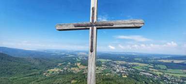
Forest Church
After returning to the main road, we continue further up to the next short turn. The turn is very short, but also quite steep. At its end, the first view awaits us – the Hajní kostel.

View from the Hajní church
From the top of the rock there is a wide view of the surroundings. On the one hand, Hejnice and Bílý potok are deep below us, on the other hand, the rock towers of the Frýdlant battlements are still relatively high above us.

Under the Frýdlant battlements
From the vantage point, we will return to the main road, where another climb awaits us. Initially on a comfortable journey, but it will soon end. The next section is full of large stones and is not very suitable for an afternoon walk with a stroller. Maybe in the following years this section will also be modified, but it would probably be a pity, the road would then lose much of its charm and beauty.

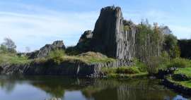
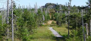
Frýdlant battlements
At the crossroads Pod Frýdlantským cimbuřím we turn left and along the yellow steep slope we ascend to the Frýdlantské cimbuří itself, probably one of the most beautiful places in the entire Jizera Mountains. The terrain here is a bit wilder, the ridge in these places is formed by a number of granite rocks. A lookout was built on one of them, where a short detour will lead us.

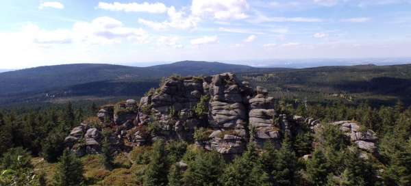
View from the Frýdlant battlements
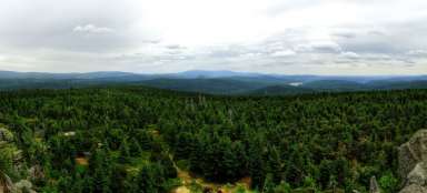
The view from this viewpoint is even better than from the Hajní church, which is now about 200 meters below us. We can see a rocky ridge stretching to another goal today, the Noon Stones. Then Ořešník, Ptačí kupy, Holubník, Klínový vrch and of course the highest peak of the Jizera Mountains – Smrk.

Noon stones
After enjoying the viewpoint, we continue along the yellow road towards Polední kameny. And along the way we can continue to enjoy the distant views. The path winds along the ridge between boulders and rocks and still rises slightly until we reach the limit of 1,000 m above sea level, although only slightly, the highest point should exceed this limit by 7 meters. And of course there is a great view from here as well. At the moment, we have only a little over 4 km behind us, but at the same time about 600 meters above sea level.

East view
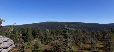
For the first time we will see Smědavská mountain and in the distance we can see the main destination, Jizera.

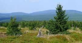
Smědavská mountain
We continue for a while along the yellow road, but in the place where the yellow one turns right (in the saddle between Polední kameny and Smědavská hora) we continue straight on a footpath that leads through a wide, straight line through a forest passage. At almost the highest point, a small rock dam dams the road. But this is not the top yet. The real peak is a little further, among the trees, a few tens of meters to the right of the road. And even here there is a small rock on which you can climb. Needless to say, there is an amazing view not only of the Jizera Mountains, but also of Ještěd or the Giant Mountains.

Jizera
We return to the footpath and continue approximately southeast. At the first significant crossroads, turn right, south. This is again just a passage, the footpath is not very clear here. But even the intersection itself will reliably lead us to Pavel's path, where we will connect to the yellow one again. This will take us to the crossroads of Paul's glade, where we turn right at the red light and reach the crossroads of Pod Jizerou. From here it is only a kilometer to the top of the Jizera (1,122 m above sea level).

View from Jizera
The peak is formed by a group of rocks, thanks to which it is easily recognizable even from a great distance. On one of the rocks there is a landscaped viewpoint offering a wonderful view, including the Souš reservoir, surrounded by almost endless forests.

Descent
We will return to the crossroads Pod Jizerou the same way. In some places there are other nice views.

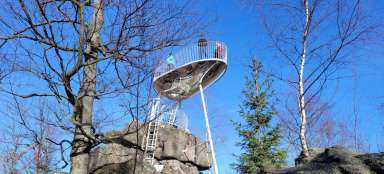
Return
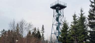
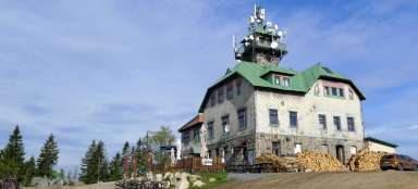
At the crossroads, turn left at the red light. The next section will be a bit duller and longer. The route leads along a wide forest road, later along an asphalt road and then along a panel road. The Knajpa mountain station (offering refreshments) can bring a bit of distraction. At the U Knejpy crossroads we leave the red road and follow the blue road towards the Čihadla crossroads, where we leave the blue road and continue along the yellow road. Just behind the crossroads is a short detour to the lookout tower, offering views of the peat bog below Montenegro. Finally, at the crossroads Nad Černým potokem, we turn right along the green, where it becomes more interesting, and soon we reach the crossroads Pod Frýdlantským cimbuřím, where we were in the morning. The rest of the way is already on the same route as the morning ascent.

Articles nearby


Giga List: The most beautiful hikes in the Jizera Mountains
The Jizera Mountains offer not only cross-country skiing in winter and bicycles in summer, but also countless beautiful tours and… continue reading
Giga List: The most beautiful trips in Northern Bohemia
Northern Bohemia offers countless beautiful trips and tours, which is not surprising, because here you will find some of the most… continue reading