Ascent to Corno Grande (2912 m)
The highest mountain of the Apennines


The mountain Corno Grande (2912 m) can be found in about half of Italy, it is the highest mountain of the Apennine peninsula and the Apennine mountain system. It is located in the central part of the Apennines, in the Gran Sasso massif, in Abruzzo. Below its peak lies the southernmost glacier in Europe. Corno Grande is part of the Gran Sasso e Monti della Laga National Park, which you may know from the movies with Bud Spencer and Terence Hill and was meant to imitate the Wild West.
Castel del Monte
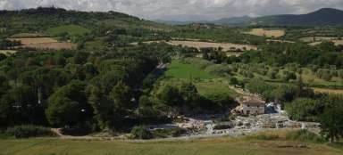
On the way to the mountain, we pass through the picturesque hilltop village of Castel del Monte. It is a medieval and Renaissance village about 27 km from the city of L'Aquila in the north of the Abruzzo region.
Located in the heart of the Gran Sasso mountain range, the village is nestled into a steep slope below the mountain peaks near the Campo Imperatore plateau, opposite the Rocca Calascio fortress and close to Monte Sirente in the Gran Sasso e Monti della Laga National Park. Filmmakers also made the place famous when they filmed several iconic films here, such as The Hawk Woman (1985) and The American (2010).

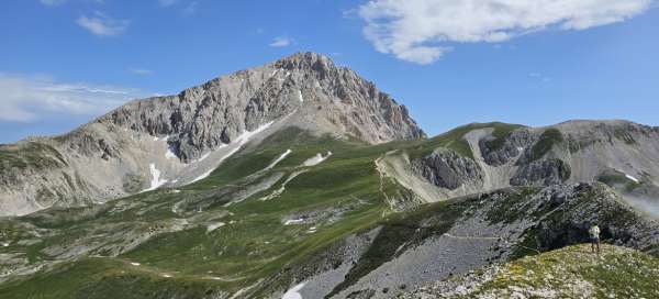
Corno Grande (2912 m)
This highest mountain of the Apennines is a majestic dominant feature of the landscape and rises from a distance as we approach it through the plain of the NP Gran Sasso e Monti della Laga.
Its name, Corno Grande, comes from Italian and means „big horn“.

The start of the journey from the hotel Campo Imperatore
The start of the ascent leads from the Campo Imperatore hotel, where you can park your car for free (we arrived in the morning and parked a few meters below the hotel along the road). Several cable cars lead from the hotel in different directions, as the location is used for skiing in the winter.
The plan today is a one-day ascent with an elevation of about 800m above sea level, and mapy.cz estimates the time to the top at 2.5 hours, which we also complied with.

Gran Sasso e Monti della Laga NP plain
As we climb the winding stony path steeply uphill from the hotel, views of the Gran Sasso plateau below us slowly unfold. We drove across the plain and camped here after the hike. It is really a unique place where you can find various animals such as wild cat or mountain chamois, which we were also lucky to see.
The park has an area of 1,413 km2 and was founded in 1991. The Gran Sasso NP plain rises from the Campo Imperatore plateau at an altitude of 1,800 m.

Above clouds
As we climb, clouds slowly begin to form below us and roll lazily over the edges of the hills below us. The starting point is at an altitude of 2,127 meters above sea level, so you can cool off here even in summer, when Italy is otherwise hot.
A small disadvantage of such an easily accessible and relatively easy ascent trek is the larger number of tourists, but don't let that put you off. A large number of visitors only go to the Rifugio Duca degli Abruzzi hut and back again.

Rifugio Duca degli Abruzzi
The chalet is located 390 meters above the hotel and provides refreshments, beautiful views and facilities for gaining strength for the next hike towards the top. The cottage has been in operation since 1908, has 24 beds and a winter room, where it stays from the beginning of June to the end of September or on weekends in May and October.

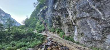
Traverse under the rock massif
From the hut there is a slower path over the ridge and alpine meadows, which will allow us to rest for a while after the steep climb to the hut. We enjoy such a nice view of the massive rock massif of Corno Grande, which is right in the palm of our hands from here.

A little snow below the summit
As we climb the side of the rock massif, we cross a few snow areas. The paths here have been trodden by passing visitors, but even so, the snow here in July surprised us a little. Fortunately, no special equipment was needed, just caution so as not to slip and possibly knock off some snow that fell into the shoes from the top.

The southernmost glacier in Europe
The final ascent to the top leads along a rocky massif, where the path is sometimes more difficult to find, especially when the last few snow plateaus are bypassed. Stones and rubble crumble under our feet and sometimes our hands as we claw our way up the last meters of altitude.
When we reach the ridge and look at the northern side of the massif, the southernmost glacier in Europe (Ghiacciaio del Calderone) lies below the top of the mountain.

The peak of the Corno Grande
We finally arrived at the destination of our route. The ascent took us an estimated 2.5 hours. There is not much room for many people at the top, but you can take a photo at the top cross. There is a strong cold wind blowing from one side, so we found a place to leeward where we go to eat a snack with beautiful views.

Lago di Campotosto in the distance
From the top we can see over the surrounding hills to Lago di Campotosto, which is only 15 km as the crow flies. Lago di Campotosto, or „Toughfield lake“ in Czech, is an artificial reservoir located at an altitude of 1,313 m and has an area of 14 km2. We used this place the next day for a pleasant mountain swim with views of the hills in the background.

Bivouac Bafile
In the vicinity of the mountain you will also find via ferratas, secured rope routes. An emergency bivouac is also located on one of these in the rock below the peak for cases of sudden bad weather. Here, it must be an adrenaline rush just to sleep in this tin shelter located on a rock ledge.

View of the plain on the way down
Now all we have to do is descend back down to the car. The first part of the journey along the steep rocky crumbling path is slow going. But there is no hurry, we have enough time, so we descend carefully. On the way, we again enjoy the views of the Gran Sasso plain below us.

Mountain chamois in the Sella di Monte Aquila pass (2335 m)
The last part of the journey does not have to follow the same route past the Rifugio Duca degli Abruzzi hut, but through the Sella di Monte Aquila pass (2335 m). This path, which will lead us to the hotel where we have parked our car, is more gradual and thus more pleasant for the descent.

Farewell to Corno Grande
Descending winding serpentines down to the plain and where we make a short stop at a pasture with horses and sheep. From here, they have an incredible view of the rock massif we were standing on just a few hours ago.