Night ascent to Acatenango volcano
Overlooking the raging Fuego


The ascent to the volcano ** Acatenango ** should definitely not be missing from the list of a true adventurer. The hike itself is very demanding, but the well-deserved reward in the form of the turbulent neighboring volcano „Fuego“: [https://www.gigaplaces.com/…ulkan-fuego/] is clearly worth it.
Exit
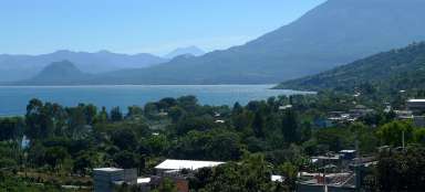
The trip started in the town of Antigua, where we chose a night variant from one of the local offices in one of the local offices. Early in the morning, their van arrived for us, and together with three other people we drove to a local guide, where less equipped members of the expedition (two boys from El Salvador who had never seen snow) took out their jackets and gloves. We also all received food packages for a day and a half. From there we drove to the foot of the mountain and set out for adventure. The first day we had „only“ 7 km to the camp with a total elevation gain of 1300m, of which a good 1000m will run during the first half. The terrain is quite demanding, most of the route leads through loose volcanic ash, so good footwear is really suitable. The first quarter of the route leads through the fields and when the sun is roasting, there is nowhere to hide. The second quarter is a bit more pleasant – it leads through the woods and there are also a few places to rest or take a break for lunch.

The first views
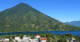
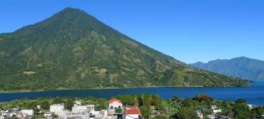
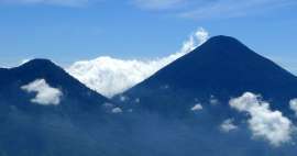
In the second half of the way, the landscape opens up to fantastic views, dominated by the nearby volcano „Agua“: [https://www.gigaplaces.com/…vulkan-agua/]. This part of the route is no longer so steep and demanding, but the fatigue is noticeable.

Fire
Volcano „Fuego“: [https://www.gigaplaces.com/…ulkan-fuego/] will appear at the very end of a difficult and long hike.

At the campsite
After arriving at the camp, we observed the volcano „Fuego“ for a while: [https://www.gigaplaces.com/…ulkan-fuego/], which spewed clouds of volcanic ash at 10–15 minute intervals. After that, however, we were overcome by fatigue, so we took a moment of well-deserved rest and woke up just before sunset.

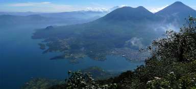
Agua Volcano
From the east side above the clouds rises the volcano „Agua“: [https://www.gigaplaces.com/…vulkan-agua/].

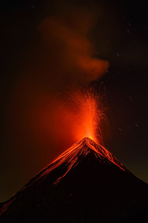
Fuego after sunset
After sunset, it becomes clear why „Fuego“: [https://www.gigaplaces.com/…ulkan-fuego/] in translation means „fiery“.

After dinner
After the dinner prepared for us by the guide on fire, the real spectacle began. On the ridge to the volcano „Fuego“: [https://www.gigaplaces.com/…ulkan-fuego/] it was possible to see a group of adventurers with headlights, who were to observe the volcano a little closer.

Pacaya volcano
In the distance on the east side behind the volcano „Agua“: [https://www.gigaplaces.com/…vulkan-agua/] was seen lava flowing from the volcano „Pacaya“: [https://www.gigaplaces.com / misto-volcano-pacaya /], to which we were the day before: „Hike to the volcano Pacaya“: [https://www.gigaplaces.com/…opku-pacaya/].

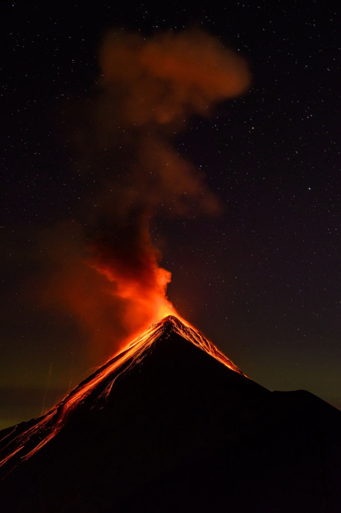
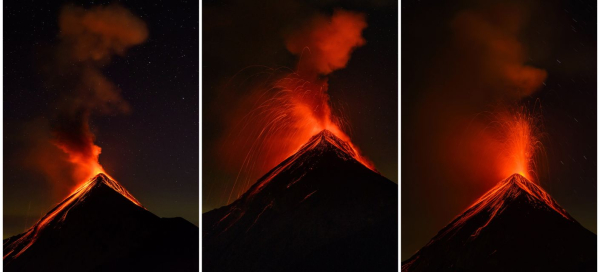
Fuego - night photography
Night photography of „Fuega“ eruptions: [https://www.gigaplaces.com/…ulkan-fuego/] with a starry sky was a fantastic experience that I would not be afraid to call the most amazing natural phenomenon I have ever witnessed.
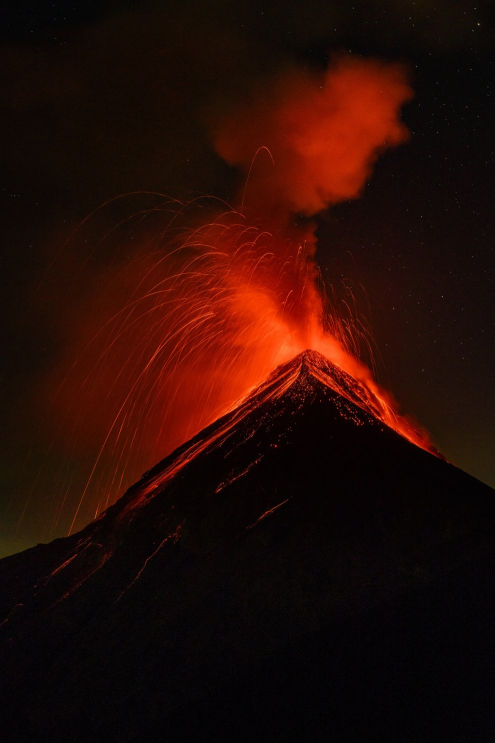
Fuego - night photography
The photography took a little over two hours. Most of the eruptions were smaller, others were stunning.
Fuego - night photography
It was not easy to capture the right moment, often requiring very long exposures, which, together with the low temperature, quickly drained the batteries.
High above the clouds
In several places below the clouds, illuminated towns shone through and the starry sky above them.

Fire
After a few hours of shooting, the temperatures began to get close to zero and it was time to go to bed. We went to bed relatively early, as it was necessary to gain a lot of strength for the morning ascent to the top of the volcano „Acatenango“: [https://www.gigaplaces.com/…-acatenango/].

Conquering the top
Getting up in the morning around 4 o'clock was quite difficult in itself and the ascent to the top was even more difficult. One member of our group stayed in the camp, apparently he did not manage to acclimatize and got altitude sickness – no wonder, he was a Dutchman and this was his first ever hike to a mountain.

Conquering the top
The terrain for the ascent was even worse than the first day, volcanic ash and dust were everywhere. Each step up meant slipping half a step back. Around 6 o'clock we reached the crater „Acatenanga“: [https://www.gigaplaces.com/…-acatenango/], from where we observed the eruption of „Fuega“: [https: //www.gigaplaces. com / misto-volcano-fuego /], waiting for sunrise.

Sunrise
Looking east, the volcano „Agua“ rises above the clouds: [https://www.gigaplaces.com/…vulkan-agua/] and the more distant smaller „Pacaya“: [https://www.gigaplaces.com/misto -vulkan-pacaya /].

Sunrise
Waiting for the sunrise seemed long and uncomfortable due to sub-zero temperatures, but it was definitely worth it.

Around the crater
Then we marched around the giant crater of the volcano „Acatenango“: [https://www.gigaplaces.com/…-acatenango/], where a strong and freezing wind was blowing.

Around the crater
Even from here, the views of the raging „Fuego“: [https://www.gigaplaces.com/…ulkan-fuego/] were fascinating.

West view
There are many other mountains and smaller volcanoes on the west side.

Around the crater
Inside the crater, someone even set up.

Last views
After going around the crater, we went down – back to the campsite.

Descent
We picked up a Dutchman at the camp, collected things we didn't take with us to the top, and continued down. Along the way, we met other groups who had no idea how challenging but beautiful hike they had in front of them.

Articles nearby


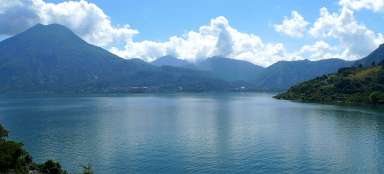


Giga List: The most beautiful trips and tours in Guatemala
Guatemala is considered the most Indian country in Central America with immense natural beauty. Tourists are attracted here… continue reading
Giga List: The most beautiful ascents to the volcanoes
If you are fascinated by the volcanic landscape and at the same time you like mountain hikes, then the ideal combination is the… continue reading