Hike from Léh to Phyang
Hike to the mountains of Ladakh


Virtually not walked great trip from Leh to Phyang in the next valley offers great views of the arid ridges of Ladakh Mountains and contrasts between fertile oases and mountain deserts. It is a perfect tip for a day lasting mountain trek without the need to travel anywhere.
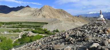
Northwest oasis of Leh
You need to go the same direction from the center of town as during a short trip to chorten on the moraine above the northern oasis of Leh (the path from Shanti Stupa to the north), but just in front of this destination you need to turn left to the west into the long next valley, where you will not meet a live soul except for a few local farmers.

Desert grazing
It is surprising that cattle do not graze only in the oasis near the glacial stream, but also high in the arid slopes.

Green oasis
After 45 minutes walking from the end of the town are the last agricultural farms. Just before them by a large chorten standing on a small hill turns quite a large side valley. But it's still not the right one!

Divine grazing
Even in Ladakh there are places where livestock feels like in paradise :-)

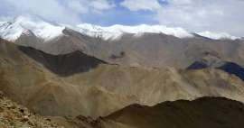
The main valley
After a while the main valley widens and you can see in the distance the main ridge of Ladakh Mountains. In these places at about 3915 meters above sea the path turns to the west into the side valley. You can make sure that you are walking the right way by the small walls every now and then damming this smaller valley and slowing down the water flowing during the spring thaw. From this junction it is still more than three hours to the pass.

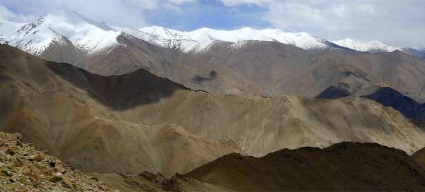
Pass in sight
After a while of the ascent through the side valley side you can already see the highest point of this hike – distinctive pass on the side ridge, from where you will descend into the valley leading to Phyang. At first look you will surely think that it is significantly further and higher than you have expected.

Look back
If you look back, you can see the walls slowing down the flow of melting spring water.

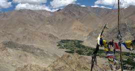
Leh oasis on the horizon
Until now relatively slowly rising path, although virtually without shade all the time, gets to the end of the valley and from here begins the hardest part of this whole hike – ascend of 600 altitude meters to the pass. The views are becoming better and better with the increasing altitude.

Nanga Sago
Directly opposite on the east towers the highest mountain directly above Leh – Nanga Sago.

Close under the pass
The views are becoming more and more amazing with the approaching pass. The only person whom you will meet in a few hours is your partner. So we definitely do not recommend undertake this trek alone as you may not be found for a few days in case of any accident.

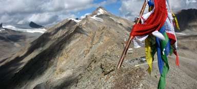
Unnamed pass (4806 m asl)
After about 5 hours walk from the center of Leh you finally ascend to an unnamed pass with stunning views to the Indus Valley, which is about 1600 altitude meters below.

The way to Lasermo la
The view from the pass to the west is definitely not as impressive as to the east. Trodden path from the pass looks at first glance as a great detour along the northern slope, so you may be tempted to come down directly, what is also possible. You can nicely see how the main path to pass Lasermo la rises through the valley. Before the road over Khardung la was built, it had been an important link with Nubra valley.

Village Dokla
The first destination during the descent is the village of Dokla (4050 m asl) – the highest located farm in the valley. A dusty road leads up to the village. If you descend from the pass through the shortcut, you will have the biggest problem to cross the river flowing here from the pass Lasermo la. It is possible that you will have to go back along the river a few hundred meters until you find a place where the flow divides into several smaller streams that you will dare to jump. The path is then very obvious – the descent along the road or the paths shortcutting the twists of the road.

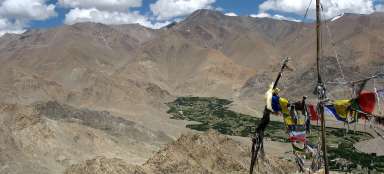
Phyang
The path from the pass through Dokla to Phyang will still take more than two and a half hours. You will descend around the agricultural land with scattered houses. If you look back, you will not be able to localize the way to pass and pass itself very well, so the way from Leh is certainly easier than the other way round. A bus to leaves to Leh around 17:30, so you will probably not have time to stop in Phyang monastery, which is significantly lower in the valley.

Stok Kangri from Phyang
There is an interesting and somewhat different view of glaciated Stok Kangri from Phyang – very nice farewell with this trip.

Articles nearby


Article: Hiking around Leh
If you arrive to Leh by air, it is ideal to acclimatize here to high altitude for at least two or three days. Moreover, in this… continue reading
Giga List: The most beautiful hikes and walks from Leh
For most tourists and excursionists, the rain is a starting point for exploring Ladakh. In addition to the classic short walks on… continue reading