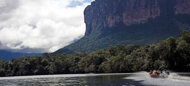
Hike Paraitepuy - river Kukenán
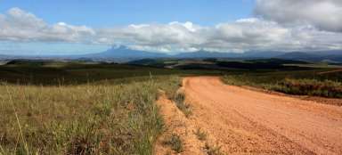
Trek through the Venezuelan savannah


** Roraima Trek I. **: The introductory stage of the trek to the monumental Table Mountain Roraima leads from the Indian town of Paraitepuy to an endless savannah, where you will be scorched by the harsh Venezuelan sun all day. You will have beautiful views of the Table Mountains practically all day. The stage ends at the river Kukenán, where, in addition to a beautiful refreshment, puri puri attacks as an unsolicited bonus.
The town of Paraitepuy
Paraitepuy (1,290 m above sea level) is a small town of the Pemon tribe and at the same time the starting point for the famous trek to Table Mountain Roraima. It is possible to sleep here, but it is better to go on a trek on the day of arrival and save some time.

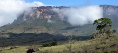
View of the Table Mountains
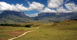
Since the village of Paraitepuy is built on a flat hill right from the bottom, you will descend about 80 meters to a nearby stream. The subsequent ascent opens up views of the Table Mountains, which are on the Venezuelan-Guyanese border. Only pieces of the former forest remain here, most of the surface of the Gran Sabana area is a grassy savannah.

Ascent to the first prospect
The actual trekking path is quite wide and rises only slowly from the stream. However, with the field full in the heat, the march is tiring anyway. The first proper view is on a flat ridge, about 110 altitude above the creek bed.

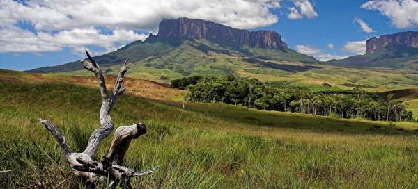
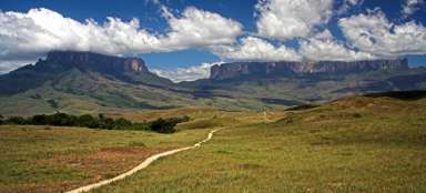
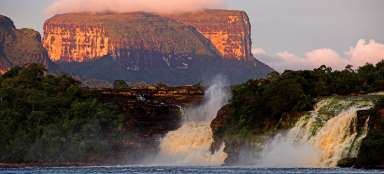
View of Roraim and Kukenán
Long kilometers of walking through the heated savannah await you from the lookout. You can enjoy the view of your destination all the time – Roraim's Table Mountain. If you are heading to the slightly lower and lesser-known Kukenán table mountain, you are also in the right place.

A small oasis by the stream
After almost seven kilometers of walking, it is the first place where it is possible to refresh yourself with water and cool off in the shade. There is a small stream crossing. An ideal place for a break.

Road to Roraima
The path leads along a slightly undulating savannah and you descend rather than gaining altitude meters.

View of Kukenán
You are slowly approaching the first campsite on the way – Ték. Just in front of it are beautiful views of the Kukenán table mountain.

Rio Ték
After three hours of walking, you are in the Ték camp. Here it is possible to refresh yourself with a beer or stay. However, if you have the time and strength, it is better to go a little further to the Kukenán campsite. From the Ték campsite you will come down to a river that you have to cross. At higher water levels relatively unpleasant. Ideal for a bath! Here you are 180 meters lower than you started in Paraitepuy.

Chapel of Santa Maria de Tokwono
From the river Ték, the last ascent of this day awaits you to the Santa Maria de Tokwono

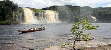
View of Rio Kukenán
You are finally at the end of this tiring stage. Below you is the river Kukenán and right next to the camp. If there weren't biting Puri Puri flies, it would be one of the most amazing camping places in the world.

Brod of the river Kukenán
The last bait of today is the crossing of the river Kukenán. Then just camping and swimming in the river.

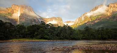
Sunset over Roraima
If the weather wishes, don't forget to come and take a picture of the sunset over Roraima!

Articles nearby


Article: Trek on Roraim
Probably the most famous trek you can do in Venezuela is to climb the most famous and highest table mountain – Roraimu. Another… continue reading