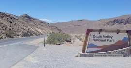
Death Valley NP - Badwater Basin
The lowest point in the Western Hemisphere


Badwater Basin is a drainless basin in Death Valley National Park, California. It is the lowest place in the Western Hemisphere. It lies approximately in the middle of the valley and is about 30 km south of the settlement of Furnace Creek. The place is quite accessible and therefore a popular tourist attraction.
The most famous place in NP Death Valley
The most famous point in the entire Death Valley National Park is certainly the Badwater Basin, located 85.5 meters below sea level.

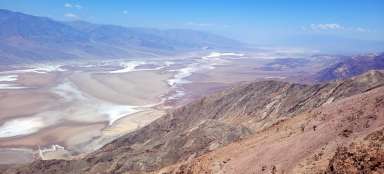
Geology of the site
Badwater Basin was formed as a result of tectonic movements that caused the area to sink several hundred meters below sea level. Originally, there was a lake in the area, but it gradually evaporated due to the dry climate. Today, Badwater Basin is covered by a salt flat that is constantly changing due to erosion.

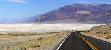
A valley between mountains
Death Valley is sandwiched between high mountains, which offers interesting scenery. The surrounding high mountains cause Death Valley to be in a rain shadow and it only rains very rarely. It is the driest place in the US.
It is interesting that the highest mountain of the continental United States, Mount Whitney (4421 m above sea level) is only 138 km away from this lowest point in the USA.

Extreme heat
The area is known for its extreme heat and dryness. Temperatures here routinely reach 50 degrees Celsius in summer and rarely drop below 10 degrees Celsius in winter. There is very little precipitation, only 5 mm falls on average per year. The record heat was recorded in 1913, when they measured 57 degrees Celsius in the shade here in July.
It is absolutely essential that visitors have enough drinking water with them.

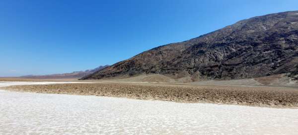
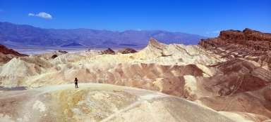
Salt flats
Badwater Basin is covered by a vast salt flat that stretches for miles into the distance. The soil is very salty and there is a salt crust on the surface. It is possible to walk on it with caution, but it can be quite slippery when wet.: There are also „salt polygons“, which are regular formations created by the crystallization of salt

Negative altitude sign
The main attraction is the Badwater Basin elevation sign, with which almost every visitor takes a photo. It is a place where they can feel like they are at the bottom of the world.

Badwater pool
Inside the Badwater Basin area is a small lake known as the Badwater Pool. The lake is called Badwater. This is because you cannot drink from it, the water is inedible. The water is not poisonous, but it is very salty.

Articles nearby


Giga List: Death Valley NP - what to see
„Death Valley“ National Park is the driest, warmest and lowest place not only in the USA, but in all of North America. It is… continue reading