
Article Ascent to Pessons
A valley full of lakes


Pessons with a height of 2,864 m above sea level is a beautiful mountain. However, it would not be particularly special in itself, there are countless similar mountains. What makes climbing this mountain an exceptional experience is above all the valley full of lakes, around which the hiking trail leads to the top. The described tour takes about 6 hours. It could certainly be done faster, but if the weather is good, it would be a shame to hurry unnecessarily.
Estany Primer
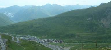
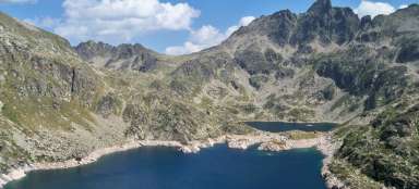
The starting point of the tour is a huge parking lot in the ski resort Grau Roig at an altitude of about 2,100 m. In winter it is probably full of people, in summer it is almost empty (at least in August 2016 it was). The first section of the path leads up mostly along the ski slope, then a bit through the forest and is a bit tiring and not very lively. However, from the very beginning, there are nice views of the surrounding mountains. After climbing about 200 meters, we find ourselves at the first lake – Estany Primer or Estany Primer de Pessons, which is also the largest lake on the route. There is a small restaurant on its shore where it is possible to have a snack. Behind the lake you can already see the mountain ridge, which also includes today's destination – the top of Pessons (right).

Estany Forcat
After less than 20 minutes of walking and climbing about 60 meters, we reach another lake – Estany Forcat. The lake is partly overgrown with grass, but it certainly does not take up space for beauty.

Third Estany
After about 150 meters, another lake follows, this time more of a lake – Tercer Estany, which, however, gets a little lost in the grass.

Estany Rodó
Right behind him is another, this time larger and deeper lake – Estany Rodó.

Estany del Meligar
We slowly climb further and at the level of 2,450 m above sea level there is another lake in front of us – Estany del Meligar. The Pessons (far left in the photo) in the background seem to be almost at hand, but it will still be some time before we reach the top.

Sisè Estany
In the meantime, several more lakes await us. Next in line is Sisè Estany, which belongs more to the smaller ones.

Estany de les Fonts
A little further on for a change is one of the larger ones – Estany de les Fonts. This time the view of the lake is „in the opposite direction“ compared to the previous ones. In the background you can see the slopes on which there are slopes in the Grau Roig area.

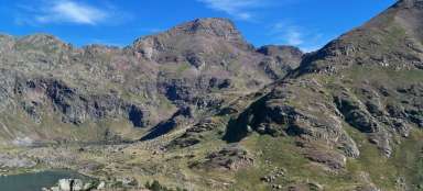
Estany del Cap del Pessons
The last lake during the ascent is the Estany del Cap del Pessons, which lies at an altitude of almost 2,600 m above sea level.

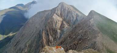
Saddle Collada dels Pessons
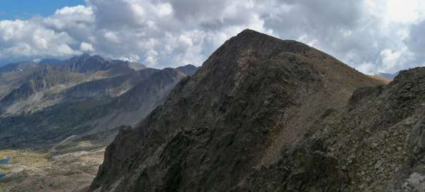
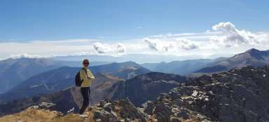
In the saddle we already have the most strenuous part of the ascent behind us and we can enjoy fantastic views. For example, to the top of Pessons (see introductory photo) or to the side ridge with the peaks of Ensagents and Pic Alt del Cubil …

View to the other side
… on the other side of the ridge, where there are other lakes …

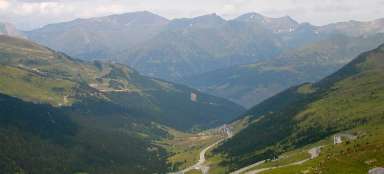
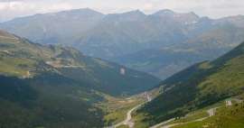
Valley view
… and especially to the valley we came to. On the right side you can also see the lakes, which the hiking trail avoids.

Top
After about four hours we are at the top. Back to the Grau Roig car park it is possible to return the same way as we came (alternatively you can turn left under the lake Estany de les Fonts and continue on a less used trail around several smaller lakes, leading parallel to the original trail, which we connect to Estana again Primer) or it is possible to continue from the summit along the ridge to other peaks Ribuls and Montmalús and then descend to the valley.

Articles nearby


Article: Trip to Andorra
As a small state sandwiched between Spain and France, Andorra offers, thanks to its location, mainly mountain hiking and skiing… continue reading
Giga List: The most beautiful mountain ascents in Andorra
Although Andorra is only a small country, due to the fact that it is practically surrounded on all sides by the Pyrenees, it… continue reading
