Article Ascent to Mannen
Around mountain lakes and snow fields


It is possible to undertake several interesting hikes to the surrounding peaks, to the glacier or mountain lakes around The Trolls' Path (Trollstigen). Difficulty of these „hikes“ is different and is indicated at the starting points on a directive in blue, red or black. In general, however, also „blue“ hikes have mostly narrow paths and rocky terrain. The indicated times are really only for very experienced hikers (and Norwegians). The ascent to the outlook peak Mannen (1 294 m asl) is not difficult, but in its last part before the summit you must overcome several rock and scree fields with confident walk and good orientation. The terrain in the valley Alnesdalen is often wet with small wetlands and even in July there may still be snowfields in the higher parts. The reward for the effort will be a bird's eye view of the valley Romsdalen and the surrounding mountains.
Lake Alnesvatnet (744 m asl)
The directive by the road will show you the way to the top of Mannen through narrow path that practically does not rise for the first kilometer and partially copies the northern shore of Lake Alnesvatnet. On the right is a distinct Skarfjellenden mountain, 1 285 m asl.

Alnestinden peak (1 665 m asl)
The trail begins to rise behind lake Alnesvatnet. We leave behind our back the ridge of Finnan, covered with remnants of snow and glacier. Below it is easily visible the road no.63, rising into the pass Slettvikane.

Lake Bortjonna (1 071 m asl)
In constant relatively slight ascent we gradually pass by several lakes. The path often leads through wet ground (jumping over stones). We start significantly rise from the next larger lake Bortjonna.

Snowfields
Wetlands from the first two thirds of the way are replaced by overcoming numerous snow fields.

Ponds and streams
In addition to summer snow it is necessary to overcome numerous mountain streams.

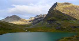
Lakes Krakenesvatna (1 016 and 1 019 m a
On the right in the direction of the ascent appear two lakes Krakenesvatna, on the left from them is the edge, beyond which is a rocky cliff, falling hundreds of meters into the valley.

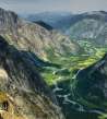
Country of lakes and mountains
After overcoming several steep stony fields we are almost at the top. Hindsight is formed by a lake and countryside of valley Alnesdalen, through which we have ascended.

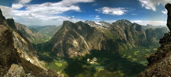
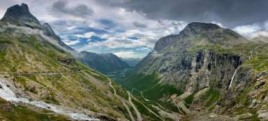
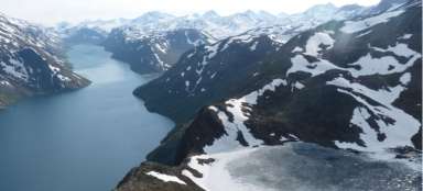
Romsdalen
View from the top of Mannen into the valley Romsdalen: the valley bottom is 1 200 meters below us.

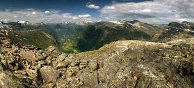
Romsdalen
And once again the view from a height of 1294 meters into the depths of the valley and the opposite mountains to the east.

On the shore of lake
We proceed back the same way. Descent through the stone fields is, of course, more difficult than the previous ascent. Respite does not come until the lakeside Bortjonna.

Alnesdalen
It is advisable to have a rest at about 1 kilometer before the destination at Lake Alnesvatnet. But the water is not very warm. The afternoon sun reveals the valley Alnesdalen in full its glory.

Mountain stream
From the lake flows mountain river, which reincarnates in about 1.5 km away into the waterfall Stigfossen and plunges into the depths of the valley. The ascent from the road to the top of Mannen is 7.3 km long with an elevation of 632 meters.

Articles nearby


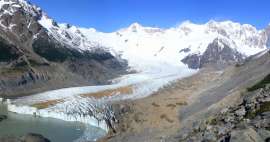
Giga List: The most beautiful hikes in the world
In this overview you will find a very beautiful, the maximum one-day hikes from around the world. Not only during long treks, but… continue reading
Giga List: The most beautiful tours in Norway
Norway is a very mountainous country and offers incredible opportunities for tourists. Due to the harsh weather, the local tours… continue reading