Tour Carhuasanta - Parihuana
March through the Amazon valley


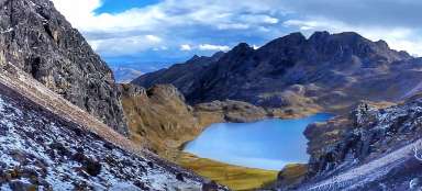
Trek to the source of the Amazon IV: The second part of the third day of the trek is marked by a march from the confluence of Carhuasanta with Apacheta to the small village of Parihuana. You will walk through a relatively wide valley full of picturesque bofedals and llamas. Along the way is a kilometer long lake Carhuacocha. Within the trek, it is easier, although a long stage (more than 20 km at an altitude of 4,500–5,000 m above sea level)
U Carhuasanty
This stage begins at the Carhuasanta farm just a few kilometers from the source of the Amazon. From here, the Mismi volcano is slowly beginning to hide behind other ridges.

Confluence of Carhuasanta with Apacheta
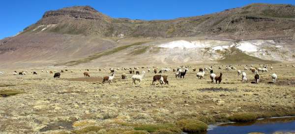
After about half an hour's walk from the farm, the valley widens a lot and Carhuasanta (Amazon) receives the first tributary – Apacheta, which is a little more powerful. Everywhere the eye can see, llamas graze.

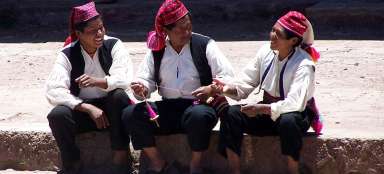
Meeting with herdsmen
From the places where llamas start to graze, there is a chance that you will meet locals as well. Even so, you will only meet two or three people in a whole day. This trek is really very deserted. The locals move quite often on horseback, which is much more practical at local distances than walking with a large backpack.

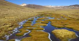
Amazon Valley
The continuation of the trek leads to an „endless“ valley full of llamas and frozen bofedals. The valley is almost 1.5 km wide and almost 8 km long. Apparently it was modeled by a glacier. The altitude here is still about 4,700 meters above sea level, so no lowlands.

Llamas in the Amazon valley
This third day of the trek is probably the most beautiful of the whole march, although also very long.

South American bofedals
A typical feature of the South American plateau Altiplano – swampy bofedals. Small green islands surrounded by streams. In the morning, when everything is frozen, you can easily pass here. In the afternoon it is often not so easy. Where there are bofedals – there is water, so there will be llamas.

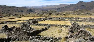
Rock castles
Remains of „rock castles“ occasionally peek out of the otherwise completely flat, weathered landscape. You probably won't have enough strength for trips to them.

At Amazon
At another abandoned enclosure for llamas, where the Amazon is already starting to look a bit like a river, a more noticeable journey is finally beginning. It begins to climb slightly away from the valley to Lake Carhuacocha. It is basically an abbreviation.

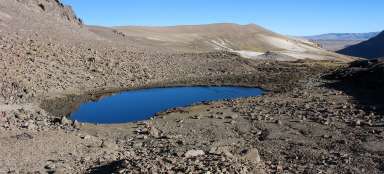
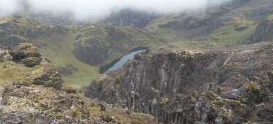
Descent to Carhuacocha Lagoon
The ascent to the terrain wave is only about 50 altitude meters. From there is a nice view of the lagoon Carhuacocha (4,646 m above sea level) about a kilometer long.

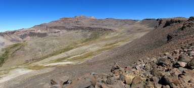
Choosing the right path
After bypassing the lake you will reach the desolate plain. You will have the most beautiful parts of the trek behind you. There are several paths behind the lake, so if you only follow the sketches, you may think for a while which way to go. An important landmark is the volcano on the horizon, about 5,020 m above sea level – your path should always lead slightly west of its top.

Views of volcanic peaks
To the west, volcanic peaks rise above the desolate plain. The slopes are enlivened by white minerals.

The last ford of the Amazon
After an hour of wandering from the lake, you will return to the slowly twisting Amazon for the last time. In these places his name is Hornillos. Looking southeast, you will see flat hills that you would not even say are about 5,000 meters above sea level.

The road through the desert
You have about 5 km left to Parihuana along the plateau. The road is already quite monotonous, moreover still at an altitude of over 4,600 meters above sea level.

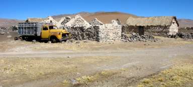
Parihuana
Parihuana (4,570 m above sea level) is not a classic village, only a few scattered buildings of llama breeders. You can either set up a tent here or sleep with someone in a „stable“. Sometimes someone comes here with a van that could throw you to the final place of the trek – Caylloma, but definitely do not rely on it and expect another long march on the Altiplan.

Surroundings of Parihuana
The area around Parihuana is dominated by the volcano, which was your navigation point. It is otherwise a place with a huge concentration of llamas, which this partially waterlogged landscape perfectly suits.

Amazon again?
Surprisingly, even though the river Rio Hornillos disappears to the west, you can enjoy the water from the Amazon again, as a large irrigation canal leads away from it. However, the march next to him will not be waiting for you until tomorrow.

Articles nearby


Article: Trek to the source of the Amazon
One of the most interesting, though not the most beautiful treks in Peru is the one leading to the source of the Amazon River.… continue reading