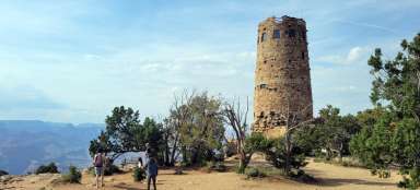
Hike Grand Canyon South Kaibab Trail
Descent to the very bottom of the Grand Canyon

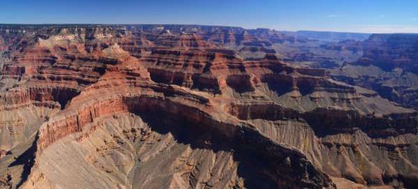


There is probably no more world-famous place than the Grand Canyon. I had the opportunity to look at the very bottom and meet the Colorado River, which is constantly digging this canyon. The hike is almost 30 km long with an elevation gain of 3000 m, where temperature fluctuations reach up to 40 ° C. On the way down I went the South Kaibab Trail and up the Bright Angel trail.
The first rays falling on the Grand Canyon
In the early morning at the beginning of the South Kaibab Trail

Ooh Aah Point
The first stop at this point. The most disgusting is almost behind me. Since the top of the Grand Canyon is located at 2100 m above sea level and there is not even 10 ° C, the subsoil does not dry out here and one steps in the faeces and urine from the passing mules.

Cedar Ridge
Cedar Ridge is located in about 1/3 of the descent, here the subsoil is already transformed from yellow to orange

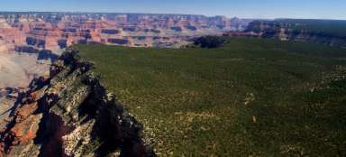
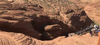
Here you can see Colorado digging its way through the canyon
I'm near Skeleton Point. From him it will go down steeply

Skeleton Point
Now begins the most painful descent.

The river is within reach
Here the sand turned almost brown. Its stones are very sharp

The last 200 altitude meters
Again, I moved a bit lower and here the sand and stones are bluish

Halfway is behind us
I'm down. The trip took me about 5 hours with breaks. Due to the fact that the temperature is around 10 ° C at the top, it is around 35 ° C at the bottom. The upper climate is mild and subtropical, so there are plenty of cacti

The local village of rangers
Here are the rangers. A little further there is a snack bar and a small camp for sleeping. It is important to get water here.

The Colorado River rarely goes clean
Most of the time, Colorado has this color. It's how it still digs this canyon.

We return with the Bright Angel Trail
We walk around the river for about 3 km and then we have a relentless climb at noon

Near the Indian Gardens
For me, the worst climb to the Indian Gardens. It is not so physically demanding, but demanding in that it is not possible to hide in the shade for a while in full heat.

In the Indian Gardens
I could rest here. Get some water. Here the climb is very gentle

The last traverse ascent
I'm below the Three Mile Resthouse. But it is the longest 5 km. There are starting to be more people who go only a few kilometers down and then up again.

Again at the top and beginning of the Bright Angel Trail
The last rays hitting the bottom of the Grand Canyon.

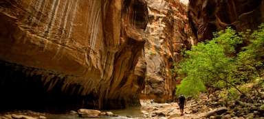
To the very bottom of the Grand Canyon
Lifeway
We get up at 5 in the morning. We pack our things for the day and cook breakfast. At 6 we set off for the Shuttle. First a blue line to the Information and then an orange line to the South Kaibab Trail. We follow a path that is not marked anywhere on the information. Americans consider it life-threatening. And so the official version is that I would have to book nights with a season ticket. What one can find on the information is the South Kaibab Trail, Bright Angel Trail and more. We were interested in these two Trails. Here, according to their instructions, one finds out how to get ready for the trip. And if a person descends, he should sleep and gain strength for the way up, but nowhere is it written that they will both walk at once. Sleeping down is not so easy either, you need to book a kempsite a few months in advance. In addition, it is easier to go with a light backpack than with a full bag. After a few meters South Kaibabu we come across a sign with Dangerous instructions. Where there is a painted stick figure and where in a free translation they literally say that if we want to get together in one day and go upstairs, we have to be in good physical condition and well equipped with water. It's just dawning on us and so we see the first rays falling on the canyon. The way down is annoying. It's around 5 ° C after a while the terror came. Shit, urine and shit again. As it is cold here and these roads are frequented by mules, they are full of feces and slurry. So I do not recommend sandals. We come to the first prospect of OOH AAH POINT and really by the name beauty. From here you can see half of our way down. After a while it starts to warm up and on Cedar Ridge, I'm putting off my first clothes. The 360 ° views really take your breath away and only the atmosphere where I am is amazing. There are two stops on the South Kaibab Trail where you can rest and there are also toilets, but be careful there is no water, so it is best to take this trail only down. We reached Skeleton Point, which is about halfway through. To imagine the Grand Canyon is located at an altitude of 2100 meters above sea level and the Colorado River at 700 meters above sea level, which is an elevation gain of 1,500 meters down and 1,500 meters up. At Skeleton Point is the steepest passage. And it really hurts here. It seemed endless to me here. The canyons change beautifully. At the top the sand is yellow, then it is orange for a long time, it turns brown below Skeleton Point and at the very bottom it is blue and then yellow again. According to these layers during the ascent, it is possible to estimate in which phase I am. We go down after about less than 5 hours. We cross the bridge. Here the South Kaibab Trail continues, but we miss the village of rangers. Here you can go rafting. There is a camp and especially water that needs to be replenished. Below is beautiful loose yellow sand and Joshua Tree, prickly pear and other types of cacti grow everywhere. Strange on top of conifers and bottom of cacti. How the climate can change. Here we have lunch we draw strength. The Grand Canyon was created by the fact that the earth's plates began to rise and, as is well known, water never flows upwards, and thus the river began to cut into the local landscape and these plates still go up and every year the river is cut 2–3 cm deeper. Therefore, a beautiful plain can be seen at the top of the canyon. We didn't meet more than 30 people on the way down. Now we continue for about 3 km along the shores of Colorado until we come across the Bright Angel Trail. The ascent here is not so physically demanding, but it is difficult due to the sun, which cannot be escaped here. I walk along the creek that leads to the Indian Gardens. I refresh myself and cool my head. It keeps running out of my head that I can't do it. I'm running out of water. Lips dry like tree bark. I only drank 2 liters of water to the Indian Gardens and I went for 2 hours. And I drank only 1 liter of water downwards. I also had to cool down at the mule drinker. The Indian Gardens are doing well. It's almost straight. The trees resemble orchards. There is also a camp for sleeping here. I get under the rocks and start traversing up. Here again is the clue of the Three Mile Resthouse. Here I take water again. And the last 5 km is endless. Fatigue is known and there are already more people who come a few kilometers down and back. I have to work it out even if he doesn't want to. Because then, in the early evening, the Ranger going up would drive me up. I drank about 5 liters of water all the time without going to the toilet. Which means how difficult this hike is. I got to the top after 6 pm.
Articles nearby


Giga List: The most beautiful hikes in the world
In this overview you will find a very beautiful, the maximum one-day hikes from around the world. Not only during long treks, but… continue reading
Giga List: The most beautiful trips in the western USA
Thanks to the beautiful landscape and dozens of national and state parks in the western United States, you can take some of the… continue reading
Giga List: The most beautiful trips in Utah
Utah is the most typical part of the American West – colorful rocks, deserts and mountains. In the south of this state you will… continue reading