Ascent to Malý Rozsutec
In a less usual way


The ascent to Malý Rozsutec (possibly connected with the ascent to Velký Rozsutec) is one of the most beautiful tours in Malá Fatra. Undoubtedly, the most attractive is the ascent through Jánošík's holes. And the high traffic of this route also corresponds to this. If you don't like to weave crowds of tourists or you already know Jánošík's holes, you can try the alternative route described below. It is not so attractive, but you will meet significantly fewer people on it. It can be managed in half a day (approx. 4 hours), it is 8 km long and the elevation gain is less than 900 m.
Príslop nad Bielou
The start of the tour is in the village of Petrová. Not far from the restaurant Jánošíkov dvor is a small parking lot for tourists. We will follow the red sign, which will lead us almost all the way (to the Zákres saddle). The road leads first along the road, which soon turns into a dirt road and rises between the meadows to the crossroads Príslop nad Bielou. Soon we have a nice view of the surrounding hills. We ascend to the saddle separating Petrov on one side and Biela on the other. We turn right and leave the wide road that descends to Biel. After a few tens of meters, we reach a crossroads, which is pointed out from a distance by a distinctive rock.

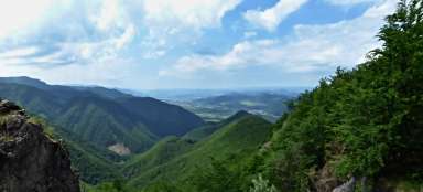
View of the White
From the crossroads we continue along the red road and we will soon reach the forest. We have a quite challenging climb on a steep slope, we climb almost 300 meters higher in about 750 meters. At the end of this section, we will be rewarded for the effort by a nice rocky view of Biel, which is deep below us and the hills that surround it from all sides.

Another climb
A very short, rest period follows. Soon the road will start to climb decently again. At 500 meters we ascend another 200 meters higher. Part of the route leads the way around a robust rock wall.

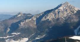
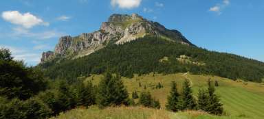
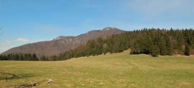
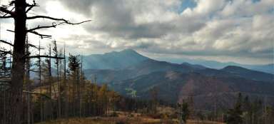
View of Velký Rozsutec
After a few minutes we will reach the next prospect. Directly in front of us we have the impressive Velký Rozsutec (1,610 m above sea level), behind which Stoh is hiding in the distance. Although it does not seem at all from this point of view, Stoh is only 2 meters lower than Velký Rozsutec.

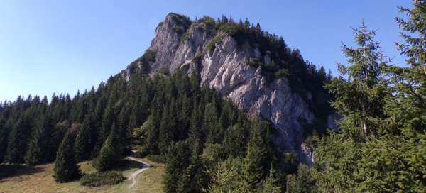
The top of Malý Rozsutec in sight
The road is not going up much now. On the contrary, it soon begins to descend to the Zákres saddle. And above the tops of the trees appears the characteristic silhouette of Malý Rozsutec.

Final output
In the saddle, our trail connects with the trail leading from the Medzirozsutce saddle and further from the holes or Velký Rozsutec. In nice weather, there are more people at once than in the previous section. From the crossroads we continue along the green and only the final ascent to the top awaits us. And another steep climb (about 115 meters at 250 meters). The most technically demanding section is secured with steel ropes and chains, and queues are also formed next to it.

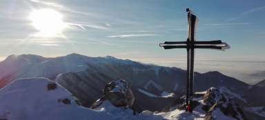
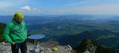
View from the top
From the top there is a beautiful view not only of Velký Rozsutec, but also of Boboty, Sokolie and other hills. Down in the valley lies Terchová.

Return
It is possible to continue along the hiking trail to Terchová (Biely Potok). However, the quickest return to Petrová is the same way as during the ascent – the 4 hours mentioned in the introduction correspond to this. If you have more time, it is possible to extend the circuit by ascending to Velký Rozsutec and return to Petrová via the Medziholie saddle. Another option is to descend to the Medzirozsutce saddle and from there descend to Terchová via Jánošík's holes. Be aware, however, that a large part of the route through the holes is one-way (from bottom to top) and for the descent it is necessary to use the green marked route to the Vrchpodžiar saddle, then the yellow one at the Podžiar crossroads and only from there continue through the blue holes.
Articles nearby


Giga List: The most beautiful hikes in Mala Fatra
Malá Fatra is undoubtedly one of the most beautiful mountains in Slovakia, it also seems to be the most beautiful mountain in the… continue reading