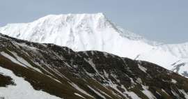
Ascent to Bazardüzü (4466 m asl)
Ascent to the highest mountain of Azerbaijan


The highest mountain in Azerbaijan on the border with Russia is a bit of a secret dream of travelers, mainly because it is „difficult to climb down“ due to bureaucracy and complexity in obtaining permits.
The village of Xinaliq.
The village of Xinaliq is inhabited by the local ethnic group with its own language and is the starting point for the trip to BC under Bazardüzü and Shahdag.

Entrance gate to the Shahdag National Park
The gate is just behind the village. Here you and your permit will be checked for the first time by NP employees.

Base Camp (BC)
It is possible to get here by car. 24.5 km from Xinaliqu.

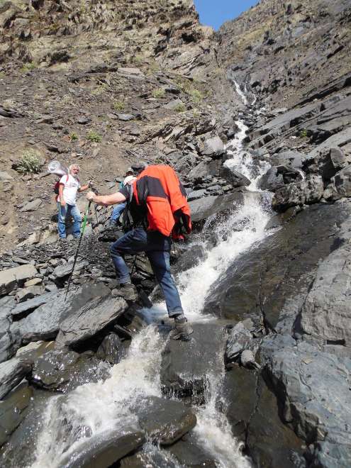
Road to BC by car.
This needs to be waded through a few times. It's deeper than it seems, the water reaching into a third of the windshield.

Base Camp (BC)
You will not meet any tourists here, maximum herders.

Road to C1.
Heavily disturbed rocks will accompany you throughout the ascent.
In C1.
Evening cool in C1, waiting for something to eat. A guide takes care of this from the jointly purchased stocks.

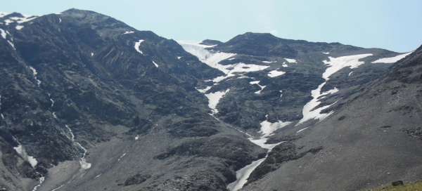
In the place of the watershed.
This river springs below the glaciers and flows south in the direction of Gebele.

Climb to the top.
A little steeper place when climbing the top of Bazardüzü. But the whole ascent is quite steep.

From the exit to Bazardüzü.
Even here, it is not exactly flat, moreover, the rubble is still sliding under your feet.

Bazardüzü, 4466 m.
A relatively pleasant ridge leads to the top itself.

Top.
At the top is a small triangle with several memorial plaques.

UAZ for wading.
This car manages a very bad road and the fords are fine. Only occasionally it is necessary to add 2 liters of water to the cooler …

Ascent to Bazardüzü (4466 m asl)
The first to third day of the ascent.
Perhaps the most attractive, but also probably the most time-consuming ascent in Azerbaijan is the ascent to the highest mountain in Bazardüzü, 4466 m above sea level. The mountain lies on the border with Russia, the Republic of Dagestan and is located in the Shahdag National Park. Due to the border and the national park, a permit is required to exit, and a guide is also required. Resp. I don't know that anyone has been granted permission without a guide. Of course, an experienced hiker can get up with a little luck and effort, possibly even by himself, but it can be quite difficult when you don't even know where the mountain is. There is nothing marked here, nor are the maps. We almost didn't know until the last moment which of the surrounding mountains Bazardüzü actually is. In the end, it was none, because it was not visible from the camps. Ascent taking into account the altitude is not technically difficult. It can be done in two days, but most expeditions come here for days three. On the first day, you will drive an all-terrain vehicle from the village of Xinaliq (2000 m) to the base camp (BC) at an altitude of 2870 m. Right behind Xinaliq, the park staff will check you at the entrance to the NP, and twice more border guards on the way to BC. The first time after a few kilometers, the second time in 18 km. On the way to BC, you have to wade a relatively steep river several times, and here you can hardly do without an off-road car. It can also be rented in Xinaliqu or a guide will take care of it. BC is 24.5 km from Xinaliqu and the journey takes 2 hours. If you want to climb in two days, it is good to move to the 1st camp (C1) at an altitude of 3243 m above sea level, from BC 2 hours through the valley and the river canyon on steep slopes with constantly running rubble, stones, weathered sand . In some places you need to be careful, because the slope is steep and slipping can mean that you end up in a river with a strong current, and it might not turn out well. Usually you go to C1 the next morning and it is conceived as an acclimatization day with the fact that in another 2.5 hours you can go to see the watershed and the local alpine lake with cold water, where the madmen can bathe. There is drinking water in BC and C1, tents are being set up here. The temperature in C1 in ideal weather, when only a few showers came at night and it was clear during the day, was slightly above 10 ° C at night. From C1, the path to the top leads again through the rubble very steeply uphill, due to the rubble and weathered stones running under your feet, it is sometimes necessary to go on a zigzag slope. The trail is not visible, the slope keeps sliding down and it will disappear again over time. Output with an elevation of approx. 1.2 km can be covered in 4 hours, we walked 6 hours due to the indisposition of one of us. Back from the top, follow the same path or the guide can take you along a side ridge to the hill directly above the C1, from where you can glide along a steep slope almost to the tents. The way back on the same route takes about 2 hours, you slide the rubble as if it were snow. You don't need cats to climb, the glacier and the remnants of snow are only on the north side of the mountain and the ascent is from the southeast. But snow covers are good so that the rubble does not fall into the shoes. After the ascent, it is possible to sleep again in C1 or pack up and go to BC and possibly immediately leave the mountains and through Xinaliq to civilization.
Articles nearby


Giga List: The most beautiful tours in Azerbaijan
The eastern tip of the Caucasus, which is not so high in this part, extends into Azerbaijan. Even so, you will find several… continue reading