Ascent to Ercyies Dagi
Ascent to the highest mountain in Central Turkey


Ercyies Dagi volcano (3,917 m above sea level) is the highest mountain in Central Turkey. It is a real dominant, because there is no other similarly high peak in its vicinity for tens of kilometers. It thus belongs to the ultra-prominent peaks. However, due to this, bad weather attracts both the magnet and strong storms are very common here. The classic ascent to this peak begins at the ski resort at about 2,200 meters above sea level.
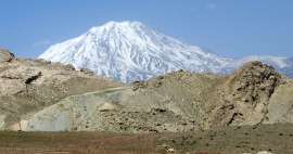
Ercyies from a distance
You drive along the Anatolian plateau at an altitude of about 1,400 meters above sea level and from a distance you can see your destination – the mighty Ercyies, which exceeds you by two and a half kilometers

Volcano from the mountain road
We are going from the south, so our starting point is the town of Develi (1,250 m above sea level). The road is covered with quality asphalt, because it is for the local shortcut to the big city of Kayseri. After about 20 kilometers drive from Develi we are in the ski resort (2,200 m above sea level)

View back to the ski resort
The ski resort is basically built in a small pass. There is plenty of parking space and the ascent from the bottom is very easy on the rocky slope next to the cable car

Ascent under the cable car
We're here in the late afternoon and it's getting cold and it's getting cold. The surrounding landscape is deserted and gloomy, only on the horizon are pieces of the main volcanic ridge peeking out

Plato under the main ridge
After passing the final ski lift, after a while you will reach a relatively „flat“ plateau at an altitude of about 2,800 meters above sea level. An ideal place to set up a tent and wait for the morning. There is even a prepared plot surrounded by a small tomorrow. The night is hard here if you forget to bring a sleeping bag

Sunrise under the volcano
The sunrise looks quite promising even though the peak is still under a cloud

Ascent to the ridge
We choose the recommended ascent path along the long southern ridge. Thanks to the clouds below us, the view is quite interesting, which is not the rule for dominant volcanoes

View of the camp from the ridge
It is good to see our campsite from the ridge. An vacated hut at the end of the cable car, then a lift turntable and finally our tent on a patch. In good weather, everything is absolutely obvious, but when the fog falls, then look for it among those small volcanic ridges.

Road along the ridge
The surrounding rock is cracked, there are steep rubble slopes on both sides and there are dozens of strange volcanic rocks. It's the end of September, so it's quite cold at these heights

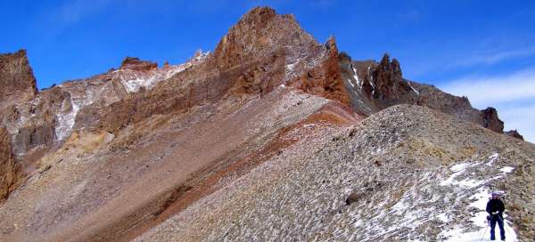
The most beautiful part of the output
The most beautiful part of the ascent was for me at an altitude of about 3,300 meters above sea level. Beautiful views of the ridge, down to the „pregnant woman“ and two distinctive pre-peaks. Probably the most photogenic places from the whole tour

View of the top of the volcano Ercyies Dagi
Finally we reach the pre-peak, about 3,630 meters above sea level. The weather is bad, but eventually the main peak is revealed. It shows the end of a comfortable trail in the form of several tens of meters high rocks. Even the top itself is a high rock of cracked material

Just below the top
The sun is rising from the clouds for the last time today and we are enjoying the deserved views. In retrospect, not even the pre-peak looks completely bad

Look down
The ski center from here looks quite deep and far away. On the plain you can see a jeep road and another basecamp, so with traffic it can be quite accelerated. On the other hand, with this variant, you have to climb the rubble corridor and you have no views from the ridge

Under the top rock
We are at the heart of the whole ascent under a high rock at an altitude of about 3,700 meters above sea level, so 200 meters below the main peak.

Finish
Before we decide whether to try to climb the rock or to bypass it from the right and climb to the top with that steep rubble trough, the azure becomes total milk and in the distance it starts to thunder. So we give it up relatively close to the goal. We return back along the ridge, although we originally wanted to speed up the descent through the trough, but we really can't see a step. We pitch a tent during a storm and run into that vacated hut. Iron is pouring in everywhere and water is flowing, so it's also not an ideal safe from lightning. When the worst subsides, we go down as close as possible to the columns from the cable car so that it eventually shatters into them instead of us, but I don't even know if it was a good tactic at all.

Articles nearby


Giga List: The most beautiful trips in the east of Turkey
Most visitors to Turkey know only its coastal riviera in the south or west of the country, or the capital Istanbul. But the… continue reading