
Tongariro Alpine Crossing Tour
The most beautiful one-day march

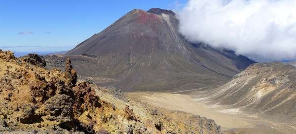


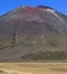
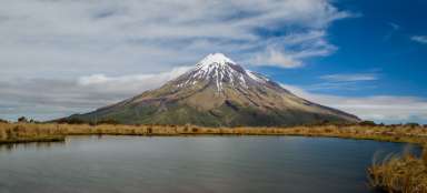
Tongariro Alpine Crossing is probably the most famous day trip on the North Island. Here you walk through a volcanic landscape used as the land of Mordor in the Lord of the Rings trilogy. The clear dominant feature of this hike is the Ngauruhoe volcano (2,287 m above sea level) in the film named as Mount Doom, which you can also climb as (the best recommended side trip on this hike). Along the way, you will also see beautiful Emerald Lakes and other volcanic formations, including the surreal Red Crater.
Under Mount Doom
This beautiful hike starts in the Mangatepopo car park (1,125 m above sea level), where a six-kilometer road branching off from the main road number 47 leads through the desolate landscape. The hike is long and if you want to catch side walks, start the march at dawn.

Ascent through the Mangatepopo valley
From the parking lot, a long and slightly monotonous climb through the desolate landscape along a nice sidewalk awaits you. After less than an hour, you will be approaching the saddle under the volcano. The car park will be lost deep below you.

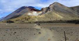
In the saddle below Mount Ngauruhoe
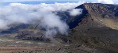
In an hour's walk you are already in the saddle (1,650 m above sea level), or at the beginning of the volcanic plain under this beautiful volcano. Only a minority of tourists climb this mountain as an interesting side trip, which is a shame, because from the top there is a beautiful view of two other interesting lakes Tama and the highest volcano far and wide Ruapehu (2,797 m above sea level). The ascent path is pretty clear from here. From this point begins the most beautiful part of the Tongariro Alpine Crossing march.

Ascent ridge
From the indistinct wide saddle below the Ngaurohue volcano, a more than a kilometer-long journey across the desolate plain, still at an altitude of about 1,650 meters above sea level, awaits you. Finally, the plains await you ascent (more than 200 meters high) along the ridge to the top of the Red Crater. The views back to the volcano are beautiful.

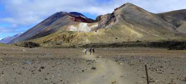
Red crater
Right next to the interesting Red Crater is a crossroads of hiking trails (approx. 1,850 m above sea level. From here you can alternatively set off to the top of the indistinct Tongariro volcano.

Above the Red Crater
If you do not take either of the two side ascents to the volcanoes, then the view directly to the Red Crater is the highest point (1,880 m above sea level) of this entire hike.

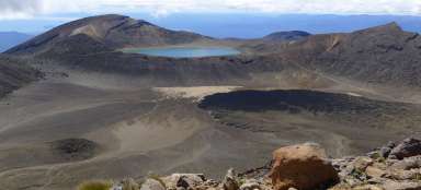
View of Emerald lakes
From the Red Crater you will descend to another volcanic plain. Along the way, however, there is perhaps the most beautiful view ever – the Emerald lakes.

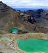
Emerald lake
The lakes are really beautiful. If you want the weather, do not rush in this passage and go around all the lakes.

View back from the lakes
The view from the lakes to the path you came from, winding over the steep slopes of the crater, is also interesting.

Views from the volcanic plain
From the lakes you will descend a little more to another vast volcanic plain. The further you go on the plain, the more panoramic the view of the volcanoes. It is beautiful to see from here that the Red Crater is just a small remnant of a once huge volcano.

View of the volcanic plain
At the end of the volcanic plain, aka the central crater, the last short ascent to the next edge of the crater at Blue Lake awaits you. The path along it leads relatively along the contour line. Even the view from here is quite interesting, especially the relatively „fresh“ black lava flow.

Views of Lake Rotoaira and Taupo
Finally you arrive at the pass from where you can see really far to the huge Lake Taupo and a little smaller but closer Rotoaira

Road to Ketetahi
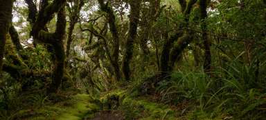
The journey down seems endless after a day's hike and not so interesting anymore. You also have to descend a kilometer high. Along the way, you will meet fumaroles and finally walk through the misty forest to the parking lot. It is still about nine kilometers from the pass.

Articles nearby


Giga List: The most beautiful hikes in the world
In this overview you will find a very beautiful, the maximum one-day hikes from around the world. Not only during long treks, but… continue reading
Article: Trip to Tongariro National Park
Tongariro National Park, located almost in the middle of the North Island, is one of the most interesting areas in New Zealand.… continue reading
Krásná celodenní tůra. Dal bych i 4.5, ale přístup místních ubírá na zážitku. Donedávna byla možnost pro skupinky se dvěmi auty nechat jedno na parkovišti "A" a druhým se svézt na parkoviště "B". To již není možné a jediný způsob jak tůru absolvovat je nechat se svézt hodně předraženými autobusy.