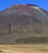
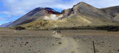
Ascent to Ngauruhoe volcano
To the most beautiful volcano in Mordor


If the weather is nice and you have enough energy, you can extend the famous one-day March of the Tongariro Alpine Crossing by two more side trips. The ascent to the Ngauruhoe volcano (2,287 m above sea level) is significantly more demanding and longer. The rubble road is not very pleasant, but the peak views and the walk around the crater are definitely worth the effort.
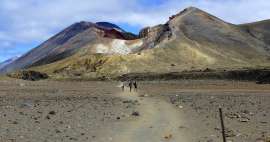
Ascent path to Mount Ngauruhoe
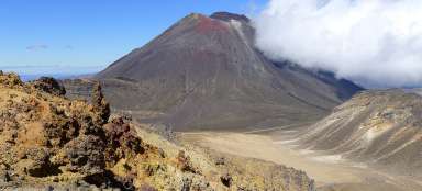
The way up to the volcano will not be what you would like to remember. Basically, it's just a vertical path in volcanic dusty rubble in the style of two steps up one down. On the other hand, this terrain has the advantage of descent. Those who are not afraid and can do it can then „run down“ the whole slope and be down in the clutches of flight.

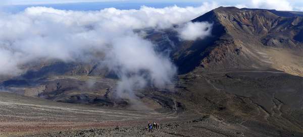
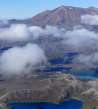
Game of clouds over Tongarir
Throughout this unpleasant ascent, you can clearly see the Tongariro Alpine Crossing route deep below you and the indistinct Tongariro volcano on the other side of the volcanic plain. It really is true that the weather here changes every moment. Clouds can appear here in a moment and then break again or, in the worst case, it will start to rain or snow.

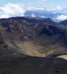
At the top of the crater
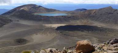
After less than two hours, you will finally be at the top of the volcano. However, the trip does not end here, a tour of the entire crater awaits you, which together is more than a kilometer. At least it pays to walk to the southernmost part from where there is a great view of the highest volcano Ruapehu and Lake Tama

Southern peak
Here, too, you sometimes meet tourists, but there are only a fraction of them compared to those that go down the main route. As on any volcano, you have a strange feeling when you walk around the crater and it stinks around you – what if …

Road through the crater
Even the actual march along the edge of the crater has its charm. There are multicolored rocks around you. After a while, the side volcano Ruapehu also looks out.

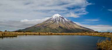
Royal view of Ruapehu
From the southern peak is the best viewpoint, the main reason to climb Ngauruhoe volcano at all. The mighty Ruapehu rises on the horizon and below you a desolate landscape enhanced by the beautiful lakes of Tama. The game of clouds is just a nice bonus.

Path along the edge of the crater
The actual path along the edge of the crater is quite paved. Only be more careful when bypassing volcanic rocks.

Roughly picturesque crater
Thanks to the multicolored rocks, the crater is in a way also picturesque and the path around it is not boring at all.

Mordor in the palm of your hand
After half an hour, even with love, you have the top circuit ready. Before the descent, you can once again enjoy the landscape of Mordor below you and you can clearly see the path that still awaits you today. The main route of the trek across the volcanic plain looks almost like a highway from a height. You can also see the ascent to the Red Crater (the highest point of the trek without sidetrips) and the second side trip to Mount Tongariro.

View of the Blue Lake
The beautiful Blue Lake can be seen in the distance.

Articles nearby


Article: Trip to Tongariro National Park
Tongariro National Park, located almost in the middle of the North Island, is one of the most interesting areas in New Zealand.… continue reading
Giga List: The most beautiful ascents to the volcanoes
If you are fascinated by the volcanic landscape and at the same time you like mountain hikes, then the ideal combination is the… continue reading