Hakone area and Joren Falls
A circular route through the north and center of the Izu Peninsula.

A one-day trip by car gradually takes us to the mountain scenic road, to Lake Ashi, the Hakone temple complex, the Joren waterfall in the center of the Izu peninsula, and ends at the old Amagi-san tunnel.
Izu Skyline
We climb from Ito City up into the hills to the start of the Izu Skyline toll road. The road is 40.6 km long and the mountainous terrain offers wonderful views of both the east and west coasts of the Izu Peninsula.

Izunokuni
Torn clouds are chasing just above us, the landscape is changing every moment. A densely populated area around Izunokuni appears to the southwest of us.

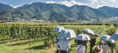
Rice fields
In Japan, rice is not only a staple food, but also an important part of Japanese society. It is said that once upon a time it was also the currency with which taxes were paid and the samurai received it as a wage. The sun's rays broke through the clouds for a few seconds and lit up the rice fields below us.

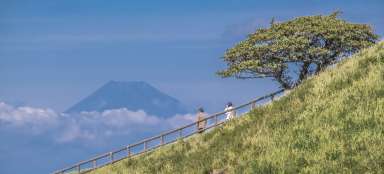
Mt. Fuji
The Izu Skyline mountain road is also driven for this view. Say hello to our favorite iconic volcano.

Numazu
While we are surrounded by mountainous nature, on the west coast of the peninsula is the densely populated town of Numazu.

Mt. Komagatake
We leave the tolled mountain road and drive down to the town of Hakone. Above it rises the 1,357-meter-high lava wall of Mount Komagatake, which erupted 40,000 years ago.

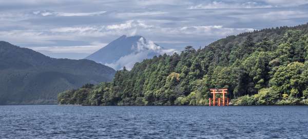
Ash Lake
Lake Ashi (or also Lake Ashinoko or Hakone) fills a volcanic crater. The last volcanic eruption occurred here in 1170.

Hakon
The city of Hakone is a tourist center. A popular pastime here is boating on the lake with a view of Mt. Fuji.

Hakone Shrine
Hakone Shrine was founded in 1191. The complex of buildings above the lake is a popular destination.

Ash Lake
The lowest point of Hakone Shrine is a popular spot for selfies with the lake waters in the background. It's not easy to take this picture and not have any people in the frame.

Joren Falls
We are moving from the north to the central part of the Izu Peninsula. Our next destination is the Joren Falls, located on the upper reaches of the Kano River. The water falls from 25 meter high basalt cliffs. According to the information board, we see one of the 100 most beautiful waterfalls in Japan – it is not stated how many places in the order it is.

Wasabi
The wasabi plant thrives in cool, shady, misty mountain streambeds near the natural forest canopy. After all, various wasabi products can be directly tasted here while enjoying the falling and thundering waters of Joren Falls.

Kano River
Far less visited, but still attractive, is the bed of the Kano River, which supplies the Joren Falls with its waters.

Amagi-san
We turn off road No. 414 onto a path that winds its way up to an old stone tunnel. We are surrounded by the mysterious nature of the Amagi forest. And this is our last stop on today's journey through the Izu Peninsula.