Article Hike over Kargil
Through oasis to the east of Kargil


It is truth what is said and written about Kargil (2,700 m asl) – there is not much to see. However, if you have from any reason free half a day, you can undertake here very nice trip to the places where you will not meet a single tourist. From Kargil lying at the confluence of Suru and Wakhi rivers leads little known dusty small road over the mountains to Baltik already lying in the wild canyon of Indus. In the vicinity of this road there are nice oasis and they are the aim of this hike.
Production of bricks on the upland plain
The beginning of this trip is slightly boring. Walk from the center of Kargil along the road upstream the river Suru before you reach the other bank in about a kilometer. Cross the bridge and start to ascent to the upland plateau (2 830 m asl) between Wakha and Suru rivers. Do not be misled by the buildings around. The upland plateau is bordered on the horizon by something like a mound, below which leads the road to Lamayuru or to Leh. The top of this mound is your first destination and the first nice outlook point on this trip.
Along the way you may see locals producing adobe bricks the old way.

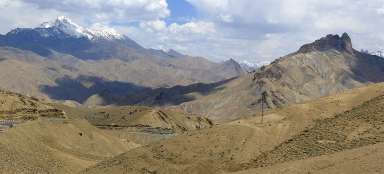
At the mound above the valley
You can best ascent to the outlook point from the northern end of the mound, along the path around the irrigation channel.

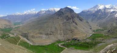
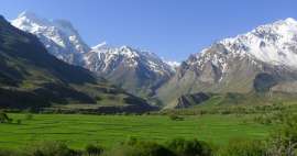
Green valley of river Wakha
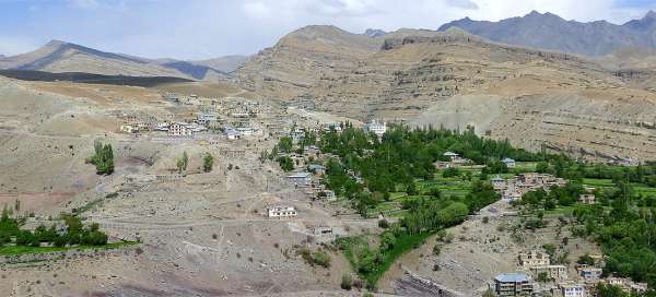
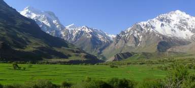
From the outlook „mound“ there is an amazing view of the green valley of Wakha river in an otherwise completely arid moonscape of Ladakh.Directly against you across the valley lies a village Akchamel, the second destination of this trip.

Oasis above the valley Wakha
It is worth to make a longer walk after admiring the views from the outlook „mound“, because slightly different views of the same scenery open then. But remember that you need to get back to the very beginning of the mound, where leads an old footpath down to the road to be able to get down to the river Wakha and on to Akchamel. The key point is then a bridge across the river Wakha, which is clearly visible from here. You will go to Akchamel not only along the road, but also along the old path shortening its twists.In the distance you can see the pass looking like big flat U. This way leads the path to Batalik in the canyon of Indus.

Green snake
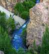
The river Wakha gradually abandons the oasis and flows several kilometers in the desolate canyon just like a green snake. It is the perfect place to turn around and return back along the mound. Or alternatively faster – run down 200 meters to the road and come back along the road to the beginning of the mound.

The village Yokma
Typically ladack view – an oasis surrounded by barren mountains. This oasis is called Yokma and you'll go back to Kargil through it. Along the white mountains to the left leads „Line of Control“, so you will sometimes see various guard buildings on the local hills.

Mosque in Akchamel
After you descent along relatively uncomfortable path from the mound down to the road, go across the river over the bridge and ascent in twists up – you'll reach Akchamel (2 900 m asl). The most impressive building is here of course the mosque.

View of the valley
It is worth to walk a few tens of meters to the cliff from the mosque, because there is a nice view to the next green oasis.

Brickmakers in Yokma
If you do not want to return the same way, you need to ascend more than a kilometer to Akmachal along the barren plain (approx. 3 030 m asl). The outlook is here much worse than you probably expected. Then you need to pass side valleys and descent to Yokma (2 860 m asl) along the old pastoral path.

View of the mound
Just walk a few meters from the village and an outlook to „mound“ will open from the profile. Truck driving underneath looks from it like a tiny crumb.

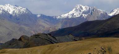
Region over Kargil
Then awaits you relatively long descent along the main road. The views from here are also quite interesting.

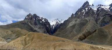
Canyon of river Wakha
At one point is the view of the canyon quite interesting.Then awaits you just the final descent into Kargil.

Articles nearby


Article: Traveling in West Ladakh
Most travelers just pass through West Ladakh on their way from Kashmir to Leh or vice versa, or on their way to Zanskar, and that… continue reading
Giga List: The most beautiful trips in Ladakh
Ladakh is a slightly different India, not for nothing is it Little Tibet. It is a very mountainous, high-lying area. Here you… continue reading